CA Market News
5日前
CA Market News
5日前
Saga Metals Consolidates Legacy Lithium Project and Expands Large Contiguous Lithium-Focused Land Package in Eastern James Bay, Quebec Amid Spodumene Price RallyJune 24, 2026 7:30 AM
NewsfileVancouver, British Columbia--(Newsfile Corp. - June 24, 2026) - SAGA Metals Corp. (TSXV: SAGA) (OTCQB: SAGMF) (FSE: 20H) ("SAGA" or the "Company"), a North American exploration company focused on critical mineral discoveries, is pleased to announce the formal consolidation of its Legacy and Amirault Lithium projects into a single, expanded Legacy Lithium Project in the prolific Eeyou Istchee James Bay region of Quebec. The Company has completed a targeted work program on the southern portion of the project (formerly Amirault), returning encouraging field observations that reinforce the presence of lithium-cesium-tantalum ("LCT") pegmatite signatures across the property.In addition, Saga has completed strategic staking of prospective metasedimentary rocks and known pegmatite occurrences in the area, increasing the total land package of the consolidated Legacy Lithium Project to 72,107.64 hectares (178,181.77 acres) from an original 65,849 hectares."The consolidation of Legacy and Amirault into one cohesive project, combined with the strong LCT mineralogical indicators we continue to see, significantly enhances our exploration thesis in one of the most exciting and active lithium districts in North America," said Michael Garagan, CGO of Saga Metals. "The consistency of key indicator minerals such as muscovite, garnet, and apatite in pegmatite samples across both the northern and southern portions of the project is highly encouraging and supports the potential for a district-scale LCT system." Highlights: District-scale lithium-focused land package: SAGA has consolidated the Legacy and Amirault projects into one expanded Legacy Project totaling 72,107.64 hectares in Quebec's Eeyou Istchee James Bay region, one of North America's most active hard-rock lithium exploration districts.LCT pegmatite indicators extended across the project: Recent field work on the southern portion of Legacy (formerly Amirault) identified pegmatite samples containing muscovite, garnet, and apatite, consistent with LCT indicator mineralogy observed elsewhere on the project. SAGA is awaiting grab sample assays from recent field work and will incorporate the results into its exploration model as it advances planning for future exploration programs.Rio Tinto field work strengthens the technical dataset: Over the past two field seasons, while the northern Legacy claims were under joint venture with Rio Tinto Exploration Canada Inc., a 342 km² helicopter-borne aeromagnetic survey was completed, generating 7,132 line-kilometres of high-quality geophysical data.Enhanced exploration targeting: The aeromagnetic survey identified numerous magnetic highs and lows that warrant further investigation for potential LCT pegmatite mineralization. Regional consolidation activity supports SAGA's strategy: The recently completed Li-FT Power / Winsome Resources transaction highlights the increasing attractiveness of the James Bay region. Adina is considered one of the largest hard-rock lithium resources in Canada and among the top five hard rock lithium resources in North America. Improving lithium market backdrop: The 2026 recovery in spodumene concentrate prices has improved the outlook across the lithium sector and provides a more constructive market environment for exploration-stage lithium assets.Figure 1: A map of the "Lithium Neighborhood" at the consolidated Legacy Lithium Project in Eastern James Bay, QuebecTo view an enhanced version of this graphic, please visit:
https://images.newsfilecorp.com/files/12336/302656_df8b6f3bb411fa49_001full.jpgRegional Consolidation Activity of the Adina Lithium ProjectThe Eeyou Istchee James Bay region of Quebec continues to attract significant corporate and investor interest as one of North America's premier hard-rock lithium districts. Recent months have seen accelerated consolidation among lithium explorers and developers, driven by the need for scale, contiguous land packages, and access to high-quality pegmatite systems capable of supporting large-scale development.Most notably, Li-FT Power Ltd. completed its acquisition of Winsome Resources Limited on May 21, 2026. The transaction, first announced on December 15, 2025, was executed via Australian schemes of arrangement and saw Li-FT acquire 100% of Winsome's issued securities.The deal adds Winsome's flagship Adina Lithium Project, a tier-one asset located in the heart of the James Bay region, to Li-FT's portfolio. Concurrent with the acquisition, Li-FT consolidated its ownership of the adjacent Galinée property (now 75% Li-FT / 25% SOQUEM), creating a single, large contiguous land package that encompasses the Adina pegmatite swarm and its interpreted extensions to the east. This consolidation is widely viewed as a strategic move to unlock the full potential of the Adina system, which hosts a substantial hard-rock lithium resource. Industry commentary has highlighted the potential for the combined Adina-Galinée package to support an 80-100+ million tonne resource base, significantly enhancing development optionality in a district where scale and contiguity are increasingly valued by investors and potential offtakes.The Li-FT / Winsome transaction is part of a broader wave of consolidation across the James Bay lithium belt. Major and mid-tier companies have been actively acquiring, joint-venturing, or consolidating claims to secure high-quality pegmatite corridors, reduce land fragmentation, and position themselves for future development or partnership opportunities. This activity reflects strong underlying fundamentals for lithium demand particularly from electric vehicles, energy storage, and strategic sectors and underscores the region's emergence as a globally significant lithium province outside of traditional supply sources.Saga believes the ongoing consolidation trend validates its strategy of building a large, contiguous land package at Legacy and positions the Company well for potential future partnerships or transactions as the district matures.2026 Spodumene Pricing RallySpodumene concentrate (6% Li2O CIF China) prices have staged a powerful recovery in 2026, rising sharply from levels around $1,560-1,590 per tonne in early January to $2,190-2,260 per tonne by mid-January. The upward momentum continued through the first half of the year, with prices climbing above $2,300 per tonne by late January and reaching $2,430-2,500 per tonne by late February, driven by tightening supply expectations, improving downstream demand in China, and bullish market sentiment. By late May 2026, prices had stabilized in the $2,500-2,600 per tonne range (averaging around $2,550/t), marking the strongest levels seen in over two years and representing a substantial rebound from the multi-year lows of 2024-2025.While prices have experienced some modest pullback in recent weeks amid fluctuating lithium chemical values, the overall 2026 run has been one of the most significant recoveries in the lithium sector. This surge has been supported by factors such as production constraints in key regions and renewed optimism around long-term demand growth.Figure 2: Legacy Property map showing the distribution of rock samples, lithology, and lithium (Li) anomalies from 2023-2025 field programs.To view an enhanced version of this graphic, please visit:
https://images.newsfilecorp.com/files/12336/302656_df8b6f3bb411fa49_002full.jpgSAGA Completes 2026 Field Activities on the Southern Block (Formerly Amirault)Saga recently completed a focused claims maintenance and prospecting program on the southern claims of the Legacy Project. The program was carried out by a four-person field crew over four days and resulted in the collection of 29 rock samples.20 of the samples were collected from pegmatites, with the remainder from paragneiss.Importantly, multiple pegmatite samples contained muscovite, garnet, and apatite — a mineral assemblage that has been consistently observed in samples exhibiting LCT geochemical signatures elsewhere on the Legacy Project.The vast majority of samples collected during this recent exploration program along the Southern Block, as noted in Figure 2, were from glacially-derived boulders and cobbles. Based on government geological maps, samples collected during previous and the current exploration programs appear to have been derived from the same pegmatite-bearing lithology that hosts LCT pegmatites along the Northern Block.These results are considered highly significant because they demonstrate that the favourable LCT-bearing pegmatite mineralogy identified on the northern Legacy claims extends into the southern claims. This continuity strengthens the case for a large, district-scale LCT system within the consolidated project area.Land Expansion and Strategic StakingIn addition to the field program, Saga has completed additional staking of highly prospective metasedimentary rocks and known pegmatite occurrences adjacent to the existing claims. This work has increased the total area of the Legacy Project to 72,107.64 hectares, providing the Company with one of the larger consolidated land positions in the James Bay lithium district.The expanded land package captures additional structural corridors and lithological contacts considered highly prospective for LCT pegmatites, while also providing strategic flexibility for future exploration programs.Rio Tinto's Aeromagnetic Survey Over LegacyA comprehensive helicopter-borne aeromagnetic geophysical survey over the Legacy Project was conducted in two phases between August 2024 and July 2025 by Geotech Ltd. on behalf of Rio Tinto Canada Exploration Inc. The survey covered a total of 342 km² and acquired 7,132 line-kilometres of high-quality data using a cesium magnetometer in stinger configuration at 50-metre traverse line spacing. The resulting datasets, including Total Magnetic Intensity (TMI), Calculated Vertical Gradient (CVG), and Digital Elevation Model (DEM) maps, reveal a magnetically active area numerous distinct magnetic highs and lows that warrant further investigation for lithium-cesium-tantalum (LCT) pegmatite mineralization.Figure 3: Legacy Project Total Magnetic Intensity (TMI) geophysical survey completed in 2024/2025 field seasons by Rio Tinto Exploration Canada (RTEC)To view an enhanced version of this graphic, please visit:
https://images.newsfilecorp.com/files/12336/302656_df8b6f3bb411fa49_003full.jpgGeotech has recommended a detailed interpretation of the magnetic results, including 3D Magnetic Vector Inversion (MVI) to accurately locate causative bodies and structures, combined with semi-automated structural analysis to identify controls on potential mineralization. Next Steps at the Legacy Lithium ProjectSAGA is currently awaiting grab sample assays and will integrate the new data with the Company's prior exploration results, Geotech's magnetic interpretation, and existing geological and geochemical datasets. This will enable refined targeting for future exploration programs. SAGA views the high-quality dataset as a valuable asset that strengthens the project's position in one of North America's most active lithium districts. The Company will provide further updates on planned work programs as they are finalized.Return of Northern Legacy Claims and Acquisition of Garneau Titanium ProjectIn early 2026, Saga successfully regained the northern portion of the Legacy Project from Rio Tinto Exploration Canada Inc. As part of the same transaction, the Company also acquired the Garneau Titanium Project in Quebec.Figure 4: Garneau Titanium Property Location MapTo view an enhanced version of this graphic, please visit:
https://images.newsfilecorp.com/files/12336/302656_df8b6f3bb411fa49_004full.jpgThe Garneau Project is within Havre-Saint-Pierre Anorthosite Complex of Quebec, a globally significant titanium-bearing district. The region hosts Rio Tinto's own Lac Tio Mine deposit, one of the highest-grade hard rock titanium operations globally.The Havre-Saint-Pierre anorthosite suite, located within Québec's Grenville Province, is a globally recognized geological setting for magmatic iron-titanium (Fe-Ti) oxide mineralization. Formed during Mesoproterozoic AMCG (anorthosite-mangerite-charnockite-granite) magmatism, the suite hosts a range of ilmenite- and hemo-ilmenite-dominated deposits, including the renowned Lac Tio operation.Mineralization in the district occurs as massive ilmenite bodies, as well as layered or disseminated Fe-Ti-P systems containing associated vanadium and apatite. This well-established metallogenic environment underpins the strong exploration potential of the region, where large-scale geophysical anomalies and ilmenite-bearing occurrences are considered indicative of prospective Fe-Ti oxide systems.Figure 5: Derivative geophysics of the Garneau Titanium Project Anomaly. (2022 Rio Tinto)To view an enhanced version of this graphic, please visit:
https://images.newsfilecorp.com/files/12336/302656_df8b6f3bb411fa49_005full.jpgExploration has outlined a distinctive ovoid-shaped magnetic low measuring approximately 4.5 km by 7.5 km, positioned along the central axis of the anorthosite complex-an environment considered highly prospective for ilmenite-bearing systems. The working interpretation is that Garneau may represent the same kind of residual magnetism-dominated Fe-Ti oxide target. Garneau's magnetic low should not be read as a lack of magnetism; in this district, it can be exactly the sort of signature associated with major hemo-ilmenite bodies such as Lac Tio.Confirmation of titanium potential of the intense magnetic response came during the initial follow-up mapping and sampling work that discovered a boulder of massive hemo-ilmenite, grading 65.1% Fe2O3, 32.4% TiO2, and 2,260 ppm vanadium. Sources:Rio Tinto - Rio Tinto Fer et Titane Operations: https://www.riotinto.com/en/operations/canada/rio-tinto-fer-et-titaneLi-FT Power announcement of the binding agreement (December 15, 2025): https://www.li-ft.com/news/li-ft-power-agrees-to-combine-with-winsome-resources-and-acquire-majority-interest-in-the-galine-property-to-unlock-value-at-the-tier-one-adina-projectLi-FT Power announcement of transaction completion (May 21, 2026): https://www.globenewswire.com/news-release/2026/05/21/3299151/0/en/lift-completes-combination-with-winsome-resources.htmlLi-FT Power Projects page (confirms completion and land consolidation details): https://www.li-ft.com/projects/Crux Investor article on the strategic rationale and land consolidation benefits (February 2026): https://www.cruxinvestor.com/posts/land-consolidation-unlocks-scale-how-li-ft-power-is-re-shaping-the-adina-lithium-projecthttps://www.fastmarkets.com/insights/lithium-spodumene-swing-supply-should-act-rationally-amid-price-uptrend-pls-ceo/https://www.infolink-group.com/energy-article/ess-spot-price-20260527Qualified PersonDr. A. Miller, P. Geo., is an Independent Qualified Person as defined under National Instrument 43-101 and has reviewed and approved the technical information disclosed in this news release.About SAGA Metals Corp.SAGA Metals Corp. is a North American mining company focused on the exploration and discovery of a diversified suite of critical minerals that support the North American transition to supply security. The Radar Ti-V-Fe Project comprises 24,175 hectares and entirely encloses the Dykes River intrusive complex, mapped at 160 km² on the surface near Cartwright, Labrador. Exploration to date, including 13,809 m of drilling, has confirmed a large, mineralized layered mafic intrusion hosting vanadiferous titanomagnetite (VTM) and ilmenite mineralization with strong grades of titanium and vanadium. The Company has signed a definitive agreement to acquire 100% of the Wolverine Heavy Rare Earth Element Project in Labrador, a near-surface REE system hosted within a peralkaline caldera complex that shares strong geological similarities with the Tanbreez and Strange Lake deposits. The project features consistent mineralization, with zones spanning 26 km2, including drill assays up to 2.03% TREO with approximately 28% HREO content, and sample assays up to 21.6% TREO.The Double Mer Uranium Project covers 25,600 hectares and features uranium radiometrics that highlight an 18 km east-west trend, with a confirmed 14 km section producing samples as high as 0.428% U3O8. (2024 Double Mer Technical Report).Additionally, SAGA owns the Legacy Lithium Project in Quebec's Eeyou Istchee James Bay region. This project spans 72,701 hectares and shares significant geological continuity with other major players in the area, including Rio Tinto, Li-FT Power, SOQUEM, and Loyal Metals.With a portfolio spanning key commodities critical to the clean energy future, SAGA is strategically positioned to play an essential role in securing critical minerals. On Behalf of the Board of DirectorsMike Stier, Chief Executive OfficerFor more information, contact:Rob Guzman, Investor Relations
SAGA Metals Corp.
Tel: +1 (844) 724-2638
Email: rob@sagametals.com
www.sagametals.comNeither the TSX Venture Exchange nor its Regulation Service Provider (as that term is defined in the policies of the TSX Venture Exchange) accepts responsibility for the adequacy or accuracy of this release.Cautionary DisclaimerThis news release contains forward-looking statements within the meaning of applicable securities laws that are not historical facts. Forward-looking statements are often identified by terms such as "will", "may", "should", "anticipates", "expects", "believes", and similar expressions or the negative of these words or other comparable terminology. All statements other than statements of historical fact, included in this release are forward-looking statements that involve risks and uncertainties. In particular, this news release contains forward-looking information pertaining to the Company's Legacy and Garneau Projects. There can be no assurance that such statements will prove to be accurate, and actual results and future events could differ materially from those anticipated in such statements. Important factors that could cause actual results to differ materially from the Company's expectations include, but are not limited to, changes in the state of equity and debt markets, fluctuations in commodity prices, delays in obtaining required regulatory or governmental approvals, environmental risks, limitations on insurance coverage, inherent risks and uncertainties involved in the mineral exploration and development industry, particularly given the early-stage nature of the Company's assets, and the risks detailed in the Company's continuous disclosure filings with securities regulations from time to time, available under its SEDAR+ profile at www.sedarplus.ca. The reader is cautioned that assumptions used in the preparation of any forward-looking information may prove to be incorrect. Events or circumstances may cause actual results to differ materially from those predicted, as a result of numerous known and unknown risks, uncertainties, and other factors, many of which are beyond the control of the Company. The reader is cautioned not to place undue reliance on any forward-looking information. Such information, although considered reasonable by management at the time of preparation, may prove to be incorrect and actual results may differ materially from those anticipated. This cautionary statement expressly qualifies forward-looking statements contained in this news release. The forward-looking statements contained in this news release are made as of the date of this news release, and the Company will update or revise publicly any of the included forward-looking statements only as expressly required by applicable law.To view the source version of this press release, please visit https://www.newsfilecorp.com/release/302656 Original: Saga Metals Consolidates Legacy Lithium Project and Expands Large Contiguous Lithium-Focused Land Package in Eastern James Bay, Quebec Amid Spodumene Price Rally
CA Market News
2週前
SAGA Metals Highlights Radar Project's VTM Enriched Magnetic Concentrate up to 0.9% V2O5 Relative to Panzhihua, China Benchmark of 0.3% V2O5June 18, 2026 7:30 AM
NewsfileVancouver, British Columbia--(Newsfile Corp. - June 18, 2026) - SAGA Metals Corp. (TSXV: SAGA) (OTCQB: SAGMF) (FSE: 20H) ("SAGA" or the "Company"), a North American exploration company focused on critical mineral discoveries, is pleased to provide a technical benchmark comparison between its 100%-owned Radar Titanium-Vanadium-Iron ("Ti-V-Fe" or "VTM") Project near Cartwright, Labrador, and the Panzhihua vanadium titanomagnetite district in Sichuan Province, China.These preliminary Davis Tube Analysis (DTA) results from the Hawkeye zone show strong vanadium pentoxide (V2O5) upgrading in the magnetic concentrate relative to the published Panzhihua VTM concentrate benchmark. The comparison focuses on potential advantages in vanadium recovery and downstream processing at the Radar Project.Panzhihua/Pangang demonstrates that VTM systems can support large-scale vanadium production with a mean grade of 0.3% V2O51 within its ore reserve. However, published Panzhihua concentrate data also show a high TiO2 burden in dressed VTM concentrate. By contrast, preliminary Hawkeye DTA test work at Radar has produced a magnetic concentrate with strong vanadium enrichment of 0.80% V2O5, including a substantial subset grading approximately 0.81-0.90% V2O5. Further encouraging results show over 86% of TiO2 is reported to the non-magnetic fraction setting the stage for a potential ilmenite-rich stream or downstream titanium product pathway.HighlightsPanzhihua is the vanadium benchmark. The Panzhihua VTM district is one of the world's most important Fe-Ti-V systems. The main Panzhihua intrusion has been reported to contain approximately 1.333 billion tonnes with a mean grade of 33% Fe, 12% TiO2 and 0.3% V2O5 (Ma et al., 2003)1 oxide ore reserves, and Pangang/Panzhihua has been reported to account for approximately 40% of global vanadium product output2.Radar shows early vanadium upgrading. A preliminary Hawkeye Davis Tube sample suite produced magnetic concentrates averaging approximately 0.80% V2O5, with a substantial subset grading approximately 0.81-0.90% V2O5 at magnetic mass yields typically in the 18-38% range.Vanadium recovery to the magnetic fraction is encouraging. For the higher-quality subset of Hawkeye Davis Tube tests, the corresponding V2O5 recoveries for the magnetic concentrate typically range from 73% to 81%. These results are preliminary and require confirmation across representative samples from Hawkeye and Trapper zones.Low TiO2 in the magnetic concentrate is a key differentiator. Panzhihua's processing challenge is that Ti in titanomagnetite reports largely to a high-Ti slag rather than to a high-value titanium product. High TiO2 in titanomagnetite concentrates can contribute to viscous slag, slag foaming, titanium-bearing furnace accretions, and complex Ti recovery. A lower-Ti magnetic concentrate may offer a potentially simpler Fe-V processing route.High TiO2 in non-magnetic fraction may carry additional value at Radar. DTA interpretation indicates that the non-magnetic fraction commonly contains approximately 86-92% of the head TiO2 and may represent a potential ilmenite-rich stream. Panzhihua remains a highly relevant benchmark because it proves the industrial scale of VTM-hosted vanadium production. In the published Panzhihua flowsheet, Fe and V are recovered principally through the magnetite/titanomagnetite stream, with vanadium reporting to vanadiferous hot metal and subsequently to vanadium slag. Panzhihua illustrates the value of vanadium in VTM systems, but also the cost of carrying high TiO2 through the Fe-V concentrate stream.Radar's preliminary Hawkeye results suggest a potentially cleaner Fe-V magnetic product, with most titanium reporting to the non-magnetic fraction rather than to the magnetic concentrate.SAGA believes this distinction is important. If the vanadium-enriched magnetic concentrate response is replicated across representative Hawkeye and Trapper samples, Radar may offer two separate evaluation pathways: a magnetic Fe-V concentrate focused on iron and vanadium recovery, and a Ti-rich non-magnetic stream focused on ilmenite upgrading. Michael Garagan, CGO & Director of SAGA Metals, commented:"Panzhihua demonstrates that VTM systems can become globally significant vanadium producers. The important distinction for Radar is that our preliminary Davis Tube tests from Hawkeye zone drill core show strong vanadium enrichment in the magnetic concentrate, while the TiO2 is primarily reporting to a Ti-rich, non-magnetic stream, which is not seen in the Panzhihua concentrate benchmark. If this response is confirmed across representative samples from Hawkeye and Trapper zones, Radar could have a cleaner Fe-V concentrate pathway and a separate Ti-rich stream for ilmenite evaluation. Encouragingly, we are seeing consistently higher grades of TiO2 and V2O5 in the Trapper zone along the 3+ km oxide strike. The next step is to turn this early deportment advantage into repeatable recovery, product-quality and process-design data."Figure 1: The Radar Property with the Dias QMAGT vertical gradient (Bzz) anomaly footprint shown in red (high-amplitude pixels only). The QMAGT-imaged central oxide-layering corridor validated over 29 km2, encompassing the Trapper Zone, Hawkeye Zone, and the new Falcon Zone.To view an enhanced version of this graphic, please visit:
https://images.newsfilecorp.com/files/12336/302009_c1a49af1a435da62_001full.jpgTechnical Deposit Comparison: Radar Versus PanzhihuaMetricPanzhihua VTM benchmark, ChinaSAGA Radar VTM Project, LabradorProject statusProducing / mature Fe-Ti-V districtExploration-stage VTM project; MRE in-progressDeposit settingLayered mafic intrusion-hosted Fe-Ti-V oxide systemLayered mafic intrusion-hosted Ti-V-Fe oxide systemReported scaleMain intrusion reported at ~1,333 Mt of ore reserves @ 33% Fe, 12% TiO2 and 0.3% V2O5 (Ma et al., 2003)124,175 ha property covering ~160 km² Dykes River intrusive complex with a 29 km2 oxide corridorVanadium contextPangang/Panzhihua is reported as a major global producer, with 2021 output accounting for about 40% of the global market2.Significant V2O5 concentrate. Vanadium recovery potential is being evaluated through DTA, Satmagan correlation and future metallurgical testing.V2O5 in magnetic concentratePublished ore reserve concentrate: ~0.3% V2O5 (Ma et al., 2003)1Preliminary Hawkeye DTA magnetic concentrate: batch average ~0.80% V2O5; substantial subset ~0.81-0.90% V2O5TiO2 in magnetic concentrateHigh TiO2 reported in titanomagnetite, reported as 12% TiO2. That TiO2 is not recovered.Preliminary Hawkeye DTA highlights over 86% of TiO2 reporting to non-magnetic fraction. (ilmenite rich in TiO2)Vanadium recovery pathwayThe industrial route recovers V via the Fe-V hot metal/vanadium slag pathway.Bench-scale DTA indicates V reports mainly to the magnetic fraction; subset recoveries commonly ~73-81% V2O5.Metallurgical implicationProven Fe-V production but high-Ti smelting and Ti-recovery complexityPotentially cleaner Fe-V concentrate and ilmenite stream with simplified processing; downstream testing required Modelling of the VTM contents at the Trapper and Hawkeye Zones returned a targeted VTM mineralized system very similar to Panzhihua VTM deposit. Despite an abundance of world resources of Ti ores, the industry continues to seek higher-quality concentrates, primarily because of processing costs and waste-disposal problems associated with the high iron and trace-element contents of ilmenite and titanomagnetite. The simple, coarse-grained VTM mineralization at Saga Metals' Radar Project has the potential for a clean VTM concentrate with high recovery. The QMAGT-imaged magnetic footprint of the central Radar oxide-layering corridor (shown in Figure 2 below) represents only a portion of the 24,175-hectare Radar Property, which entirely encloses the approximately 160 km² Dykes River Intrusive Complex. The Property's land position is shown at the same map scale as the digitized ore outline of Panzhihua's deposit, providing visual context for the relative scale of the geological system that hosts the Radar mineralization.Figure 2: The Radar Property (outlined) with the Dias QMAGT vertical gradient (Bzz) anomaly footprint shown in red (high-amplitude pixels only), shown at the same map scale as the digitized ore outlines of the Panzhihua deposit (Sichuan, China). The QMAGT-imaged central oxide-layering corridor - encompassing the Trapper Zone, Hawkeye Zone, and the new Falcon Zone - is shown for direct visual comparison with the world's most significant titanium-vanadium-iron producer.To view an enhanced version of this graphic, please visit:
https://images.newsfilecorp.com/files/12336/302009_c1a49af1a435da62_002full.jpgWhy the Vanadium Comparison MattersIn VTM deposits, vanadium value depends on deportment as much as grade. The preferred outcome is for vanadium to report with titanomagnetite into a magnetic Fe-V concentrate. At the same time, Ti is directed to a separate ilmenite-rich stream or to a downstream Ti product pathway. This is why Radar's early DTA response is noteworthy: the magnetic concentrate is enriched in V2O5 relative to the Panzhihua concentrate benchmark.The non-magnetic fraction is also strategically relevant. DTA interpretation indicates that the non-magnetic fraction contains a chemically coherent Fe-Ti-V oxide population consistent with an ilmenite stream. A theoretical oxide normalization suggests a potential ilmenite concentrate in the mid-40s TiO2 range with meaningful V2O5 content, but this must be confirmed by dedicated ilmenite separation, mineralogy and hydrometallurgical test work.With a preliminary understanding of how the Fe-V and Ti minerals are reporting within the mineralized system, further test work is underway to confirm repeatability across zones, optimize grind size and magnetic intensity, quantify mineral liberation, and evaluate downstream processing routes for both the Fe-V magnetic stream and the Ti-rich non-magnetic stream.Recommended Next StepsSAGA's next phase of metallurgical work to focus on converting the encouraging vanadium deportment and titanium-rich ilmenite signal into repeatable recovery and product-quality data. Priority work to include:Davis Tube and Satmagan/Borate Fusion calibration across representative Hawkeye, Trapper North and Trapper South lithologies, zones and grade ranges;Automated mineralogy and EPMA/SEM-EDS work to quantify vanadium in titanomagnetite, ilmenite, silicates and other phases;Grind-size and magnetic-intensity optimization to maximize V2O5 recovery while maintaining a cleaner magnetic concentrate;Preliminary downstream evaluation of Fe-V concentrate options, including smelting, roast-leach, direct-reduction or other relevant pathways;Bench-scale separation of the Ti-rich non-magnetic fraction to assess ilmenite grade, recovery, impurities and residual V2O5 value;Product-quality testing for magnetic concentrate, including Fe grade, V2O5 grade, TiO2, SiO2, Al2O3, MgO, CaO, S, P and pelletizing behaviour;Geometallurgical domain modelling and recovery/yield functions suitable for future resource-stage economic evaluation.About the Radar Critical Mineral Property in LabradorThe Radar Property comprises 690 mineral claims across 9 mineral licenses, totalling approximately 24,175 hectares in southeastern Labrador, located approximately 10 km south of Cartwright. The Property entirely encloses the Dykes River Intrusive Complex (~160 km² at the surface) and is accessible year-round via paved Route 510, a Cartwright logging road, and a SAGA-constructed access trail. Infrastructure advantages include the deep-water port at Cartwright, the Cartwright Airport (YRF), and proximity to regional hydroelectric power from Muskrat Falls and Churchill Falls.Diamond drilling, geophysics, trenching and geological mapping have confirmed a 29 km2 oxide corridor encompassing the Trapper, Falcon and Hawkeye Zones. VTM mineralization at Radar is comparable to that of global Fe-Ti-V systems such as Panzhihua (China) and Bushveld (South Africa). Subject to further exploration, resource definition, and metallurgical testing, the Project may represent a strategic source of titanium, vanadium, and iron for North American markets.Figure 3: The Radar Property with the Dias QMAGT vertical gradient (Bzz) anomaly footprint shown in red (high-amplitude pixels only). The QMAGT-imaged central oxide-layering corridor validated over a 29 km2 area, encompassing the Trapper Zone, Hawkeye Zone, and the new Falcon Zone, with additional targets highlighted to the west and north. The Property is well serviced by road access and is conveniently located near the town of Cartwright, Labrador.To view an enhanced version of this graphic, please visit:
https://images.newsfilecorp.com/files/12336/302009_c1a49af1a435da62_003full.jpgCautionary Note Regarding Panzhihua ComparisonThe Panzhihua deposit and Pangang operation are used in this news release solely as geological and metallurgical benchmarks. Published reserve, production, concentrate and process data from Panzhihua are external benchmark information and are not necessarily indicative of mineralization, metallurgy, tonnage, grade, recoverability or economic viability at Radar. Radar does not currently have a mineral resource estimate, mineral reserve estimate, preliminary economic assessment, pre-feasibility study or feasibility study. The current Hawkeye DTA results should not be treated as final product specifications. They are bench-scale pre-concentration results from selected medium- to high-grade samples. However, they provide a clear testable hypothesis for the next phase of metallurgy as described above.Qualified PersonThe technical information in this news release has been reviewed and approved by Paul McGuigan, P. Geo., a Qualified Person as defined under National Instrument 43-101. The QP has reviewed the technical disclosure relating to the Radar Project and has verified the Radar DTA/Satmagan disclosure to the extent appropriate for the current stage of exploration and metallurgical test work. Preliminary Davis Tube results are bench-scale tests and should not be interpreted as final process recoveries, final concentrate specifications or evidence of economic viability.Sources:https://www.sciencedirect.com/science/article/abs/pii/S0024493710001659https://pubs.usgs.gov/myb/vol1/2020/myb1-2020-vanadium.pdfAbout SAGA Metals Corp.SAGA Metals Corp. is a North American mining company focused on the exploration and discovery of a diversified suite of critical minerals that support the North American transition to supply security. The Radar Ti-V-Fe Project comprises 24,175 hectares and entirely encloses the Dykes River intrusive complex, mapped at 160 km² on the surface near Cartwright, Labrador. Exploration to date, including 13,809 m of drilling, has confirmed a large, mineralized layered mafic intrusion hosting vanadiferous titanomagnetite (VTM) and ilmenite mineralization with strong grades of titanium and vanadium. The Company has signed a definitive agreement to acquire 100% of the Wolverine Heavy Rare Earth Element Project in Labrador, a near-surface REE system hosted within a peralkaline caldera complex that shares strong geological similarities with the Tanbreez and Strange Lake deposits. The project features consistent mineralization, with zones spanning 26 km2, including drill assays up to 2.03% TREO with approximately 28% HREO content, and sample assays up to 21.6% TREO.The Double Mer Uranium Project covers 25,600 hectares and features uranium radiometrics that highlight an 18 km east-west trend, with a confirmed 14 km section producing samples as high as 0.428% U3O8. (2024 Double Mer Technical Report).Additionally, SAGA owns the Legacy Lithium Project in Quebec's Eeyou Istchee James Bay region. This project spans 65,849 hectares and shares significant geological continuity with other major players in the area, including Rio Tinto, Li-FT Power, SOQUEM, and Loyal Metals.With a portfolio spanning key commodities critical to the clean energy future, SAGA is strategically positioned to play an essential role in securing critical minerals. On Behalf of the Board of DirectorsMike Stier, Chief Executive OfficerFor more information, contact:Rob Guzman, Investor Relations
SAGA Metals Corp.
Tel: +1 (844) 724-2638
Email: rob@sagametals.com
www.sagametals.comNeither the TSX Venture Exchange nor its Regulation Service Provider (as that term is defined in the policies of the TSX Venture Exchange) accepts responsibility for the adequacy or accuracy of this release.Cautionary DisclaimerThis news release contains forward-looking statements within the meaning of applicable securities laws that are not historical facts. Forward-looking statements are often identified by terms such as "will", "may", "should", "anticipates", "expects", "believes", and similar expressions or the negative of these words or other comparable terminology. All statements other than statements of historical fact, included in this release are forward-looking statements that involve risks and uncertainties. In particular, this news release contains forward-looking information pertaining to the Company's Radar Project, the results of the preliminary DTA work and the comparison to the Panzhihua deposit in China. There can be no assurance that such statements will prove to be accurate, and actual results and future events could differ materially from those anticipated in such statements. Important factors that could cause actual results to differ materially from the Company's expectations include, but are not limited to, changes in the state of equity and debt markets, fluctuations in commodity prices, delays in obtaining required regulatory or governmental approvals, environmental risks, limitations on insurance coverage, inherent risks and uncertainties involved in the mineral exploration and development industry, particularly given the early-stage nature of the Company's assets, and the risks detailed in the Company's continuous disclosure filings with securities regulations from time to time, available under its SEDAR+ profile at www.sedarplus.ca. The reader is cautioned that assumptions used in the preparation of any forward-looking information may prove to be incorrect. Events or circumstances may cause actual results to differ materially from those predicted, as a result of numerous known and unknown risks, uncertainties, and other factors, many of which are beyond the control of the Company. The reader is cautioned not to place undue reliance on any forward-looking information. Such information, although considered reasonable by management at the time of preparation, may prove to be incorrect and actual results may differ materially from those anticipated. This cautionary statement expressly qualifies forward-looking statements contained in this news release. The forward-looking statements contained in this news release are made as of the date of this news release, and the Company will update or revise publicly any of the included forward-looking statements only as expressly required by applicable law.To view the source version of this press release, please visit https://www.newsfilecorp.com/release/302009 Original: SAGA Metals Highlights Radar Project's VTM Enriched Magnetic Concentrate up to 0.9% V2O5 Relative to Panzhihua, China Benchmark of 0.3% V2O5
CA Market News
3週前
SAGA Metals Reports Assays from R-0044 to R-0046 with Intercepts Including 58.33% Fe2O3, 8.78% TiO2, 0.415% V2O5 from 2026 Drilling at Trapper South, Radar Critical Minerals Project in LabradorJune 11, 2026 7:30 AM
NewsfileVancouver, British Columbia--(Newsfile Corp. - June 11, 2026) - SAGA Metals Corp. (TSXV: SAGA) (OTCQB: SAGMF) (FSE: 20H) ("SAGA" or the "Company"), a North American exploration company focused on critical mineral discoveries, is pleased to report additional assay results from drill holes R-0044, -0045 and -0046 completed in 2026 as part of its ongoing maiden Mineral Resource Estimate ("MRE") diamond drill program at the Trapper Zone within the 100%-owned Radar Titanium-Vanadium-Iron Project near Cartwright, Labrador, Canada.The Trapper Zone forms part of an oxide corridor that includes the Falcon and Hawkeye Zones spanning 29 square kilometres near the center of the Property. Figure 1: The Radar Property with the Dias QMAGT vertical gradient (Bzz) anomaly footprint shown in red (high-amplitude pixels only). The QMAGT-imaged central oxide-layering corridor validated over 29 km2, encompassing the Trapper Zone, Hawkeye Zone, and the new Falcon Zone.To view an enhanced version of this graphic, please visit:
https://images.newsfilecorp.com/files/12336/301016_df237b35d4733acc_001full.jpgTrapper South Assay HighlightsAnalytical results received for three (3) additional diamond drill holes (R-0044 to R-0046) from the MRE drill program initiated in Q4 2025, delivering consistent broad intercepts of oxide mineralization.Key intercepts include:Hole R-0044: 22.9 m @SmileyJ: 71.3 m @ 48.28% Fe2O3, 6.21% TiO2, 0.373% V2O5Including 40.0 m @civilone: 127.9 m @ 52.94% Fe2O3, 7.35% TiO2, 0.388% V2O5Including 54.0 m @ 58.33% Fe2O3, 8.78% TiO2, 0.415% V2O5Including 65.1 m @ 43.84% Fe2O3, 5.90% TiO2, 0.316% V2O5Including 20.6 m @ 54.21% Fe2O3, 7.46% TiO2, 0.426% V2O5These results now bring the total MRE drill results to thirty-nine (39) diamond drill holes received to date. As reported previously, analytical results from the first thirty-six (36) diamond drill holes of the MRE drill program include:DDHFROMTOLengthTrue ThicknessFe2O3TiO2V205IDmmmm%%%R-0008170.0237.668.366.246.159.210.311R-000994.0181.287.284.450.6710.150.339R-00101.5137.0135.5121.750.037.870.352R-001158.1153.395.250.839.496.490.222R-00123.879.075.239.627.394.870.116R-00139.5121.0111.597.937.085.140.242R-00148.850.041.214.936.176.360.188R-001573.3174.0100.788.938.566.800.229R-001644.094.650.647.152.057.210.375R-001750.6140.690.073.051.866.760.417R-001844.7115.070.344.142.645.660.288R-001966.6112.345.741.649.516.560.374R-002087.3128.040.731.137.624.930.239R-002196.0127.431.416.553.187.080.414R-002262.092.630.628.649.46.610.373R-0023100.5186.586.054.045.55.50.367R-0024112.0203.091.058.749.086.230.39R-0024142.0186.044.028.454.27.070.443R-0025141.3223.081.758.541.365.180.309R-0025168.0201.033.023.747.386.010.384R-0026141.7189.047.327.738.164.650.288R-0026110.9131.420.512.052.396.550.449R-002781.2162.080.863.442.745.180.320R-0028105.7211.0105.354.542.395.400.306R-0028144.0182.038.019.749.436.500.382R-002965.2172.0106.895.544.415.360.341R-002965.2104.038.834.753.026.460.441R-003083.1174.090.949.542.575.400.303R-003083.1101.718.610.250.816.560.398R-003163.4171.6108.287.238.115.130.254R-003197.0140.143.134.742.715.880.309R-003253.8198.0144.2135.337.135.040.234R-0032114.0170.056.052.644.686.500.294R-003367.4168.0100.677.544.076.380.286R-003397.0153.056.043.148.037.250.304R-003468.8195.0126.2124.043.196.050.293R-0034106.1170.063.962.848.617.010.344R-00358.522.013.59.930.982.930.193R-003655.0128.073.036.545.346.310.345R-003680.0114.034.017.050.467.210.395R-003752.2103.050.841.945.936.460.348R-003845.4146.2100.873.741.235.210.302R-0038103.9146.242.431.046.206.350.364R-003984.0194.0110.1106.547.425.950.354R-003997.0149.152.150.458.157.680.459R-0039166.4194.027.626.745.885.850.350R-004084.9130.045.131.951.207.940.340R-00416.653.046.434.747.976.490.368R-0042102.1137.435.323.650.686.740.378R-004328.468.239.830.447.937.240.307 Table 1: MRE drill program assay intercepts previously reported in Q4 2025 and 2026 to date from drill holes R-0008 to R-0043.Top 15 intercepts from the MRE Drill Program to date can be found in Table 4 below.Completed fifty (50) holes (R-0008 to R-0057) from Q4 2025 to date in 2026, with significant oxide intercepts including 202.3 m from R-0053 (true thickness of 132.1) of semi-massive oxide with extensive rhythmic oxide layering.MRE drilling to date has returned multiple holes of thick oxide core intercepts exceeding 70-144 metres and certain assay intervals frequently above 45-58% Fe2O3, 6-8% TiO2 and 0.37-0.44% V2O5.Rhythmic banding and semi-massive to massive oxide mineralization are observed consistently in Trapper South, aligning with prior high-grade results from Trapper North.Drilling is progressing efficiently, with 11,600 m completed in the Trapper Zone to date.Confirmed 29 km2 central oxide corridorExcellent core recovery and representative sampling support ongoing metallurgical test work and the advancement of the maiden Mineral Resource Estimate.Michael Garagan, CGO & Director of SAGA Metals, commented: "These latest results from holes R-0044 through R-0046 continue to demonstrate the impressive scale and continuity of the oxide system at Trapper South. Hole R-0046 in particular was a standout, stretching a full 490.1 m (over 1,600 feet) and reaching 280 m vertical depth while returning broad zones of strong oxide mineralization, including over 100 m of higher-grade material averaging 7.35% TiO2 and 0.388% V2O5.Holes R-0044 and R-0045 further reinforce the consistency we're seeing across the Trapper Zone, with thick intercepts of rhythmic oxide layering and semi-massive mineralization. The ability to repeatedly intersect wide zones of oxide mineralization with high grades across multiple sections speaks to the robustness of this system. These results continue to build our confidence as we advance toward a maiden Mineral Resource Estimate at Radar."2026 Trapper South Drilling SummaryDrill HoleAzimuth / DipTotal Depth (m)From (metres)To
(metres)Semi-Massive Oxide (m)Rhythmic Layering
(m)Total Oxide (m)True Thickness (m)Assays ReceivedR-001638° / -45°20644.0102.045.812.258.053.9YesR-001738° / -70°16150.6140.687.13.090.173.0YesR-001838° / -45°18844.7156.465.046.6111.770.1YesR-001938° / -45°18266.6133.038.028.566.572.8YesR-002038° / -45°20650.8138.028.558.787.266.7YesR-002138° / -70°15281.3127.433.512.646.124.3YesR-002238° / -45°14922.5118.731.659.791.385.3YesR-002338° / -45°272100.5239.330.676.4107.167.2YesR-002438° / -45°254108.9219.846.862.1108.968.5YesR-002538° / -60°275123.0253.66.9118.1125.089.6YesR-002638° / -60°302108.8273.716.2138.6154.887.4YesR-002738° / -45°21781.3175.334.259.994.173.9YesR-002838° / -60°227105.1215.922.587.1109.657.4YesR-002938° / -45°21465.2184.013.4105.4118.8106.2YesR-003038° / -60°21183.1189.225.479.6105.057.8YesR-003138° / -45°21563.4171.62.4105.9108.387.2YesR-003238° / -60°26353.8214.718.5136.0154.4145.0YesR-003338° / -45°25167.7203.523.7112.4136.1104.8YesR-003438° / -60°23348.7214.166.193.5159.7156.9YesR-003538° / -45°978.566.30.035.035.025.7YesR-003638° / -70°21247.4128.068.08.676.638.3YesR-003738° / -45°20642.6146.050.852.6103.485.2YesR-003838° / -70°18245.4146.255.945.0100.973.7YesR-0039218° / -45°25184.0196.382.223.3105.5102.1YesR-004038° / -70°17038.3130.044.728.773.434.3YesR-004138° / -45°1006.684.238.530.969.452.1YesR-004238° / -70°16188.6137.426.610.036.624.5YesR-004338° / -45°11928.4101.637.535.773.355.9YesR-0044218° / -45°17682.9105.819.33.722.916.6YesR-0045218° / -45°24539.3223.667.471.7139.196.9YesR-0046 a218° / -45°4917.4147.9121.719.3141.0108.0YesR-0046 b237.7445.921.4176.7198.2113.7YesR-0047218° / -45°305106.1247.450.871.5122.3118.1
R-004838° / -45°24231.7149.311.8105.1116.9109.9
R-004938° / -60°20030.7134.317.486.1103.666.6
R-0050218° / -45°26963.9245.651.994.2146.1103.3
R-005138° / -60°31199.9227.338.588.8127.483.0
R-005238° / -45°27568.6235.019.8140.8160.6134.7
R-005338° / -60°29977.1279.435.0167.3202.3132.1
R-005438° / -45°26918.4202.035.285.3120.597.7
R-005538° / -60°32070.1291.667.673.2140.882.3
R-005638° / -45°23984.8220.024.469.694.056.1
R-005738° / -60°23392.4194.143.652.596.183.4
Total (m)9,550
Table 2: Summary of drill holes R-0016 to R-0057, highlighting the oxide intercepts. See Figures 3-4 below, which depict the oxide mineralization in cross sections S6 and S8. True thickness represents the perpendicular width of the mineralized zone, while the total downhole oxide represents the length of the mineralization intercepted downhole.
Total Meters DrilledTotal SamplesTrapper South 202520501313Trapper South 202695505719Trapper Total116007032
Table 3: Summary of total meters drilled in Q4 2025 and 2026 to date, including total core samples cut and prepared.Figure 2: Trapper South map outlining location of the initial 2026 focus for the remainder of the MRE drill program to be completed in 2026, including cross-sections S14, S13, S12, S11, S10, S9, S8, S7, S6, S5, and S4, showing the TMI of the 2025 Trapper Zone ground magnetic survey.To view an enhanced version of this graphic, please visit:
https://images.newsfilecorp.com/files/12336/301016_df237b35d4733acc_005full.jpgThe latest results from these drill holes, R-0044, R-0045 and R-0046, once again demonstrate excellent continuity across broad zones of oxide mineralization, underscoring the growing potential for a sizable mineral resource that could create meaningful long-term value for SAGA shareholders.Detailed Logging Highlights from Drill Hole R-0044 to R-0046Hole R-0044 (Cross-Section S06): Drill hole R-0044 is drilled on cross-section S6, with an azimuth of 218 and a dip of -45°, with a total depth of 167 m. The oxide zone is 22.9m thick, intersected at 82.85m, at a sheared felsic dyke marking the contact between gabbronorite and semi-massive oxide. Oxide zone includes rhythmic oxide layering (3.7 m) and semi-massive oxide (19.3 m) ending at 105.8 m.Hole R-0045 (Cross-Section S08): Drill hole R-0045 is drilled on cross-section S8, with an azimuth of 218 and a dip of -45° with a total depth of 245 m. The oxide zone is 139.2 m thick, intersected at 39.3 m at a sharp contact from gabbronorite to rhythmic banding. Semi-massive oxide starts at a faulted lower contact of a felsic dyke at 76.8 m. Oxide zone includes rhythmic oxide layering (71.7 m) and semi-massive oxide (67.4 m). The oxide zone ends at 223.6 m at a sharp contact from rhythmic banding to gabbronorite.Hole R-0046 (Cross-Section S08): Drill hole R-0046 is drilled on cross-section S8, with an azimuth of 218 and a dip of -45°, with a total depth of 491 m. This hole tests both of the magnetic anomalies in Trapper South. The first oxide zone is 140.5 m thick and is intersected at 7.4 m at a sharp contact of gabbronorite and rhythmic layering. This zone includes rhythmic oxide layering (18.7 m) and semi-massive oxide (121.8 m). The oxide zone ends at 147.9 m at a faulted contact of a felsic dyke.
The second oxide zone is 198.2 m thick and is intersected at 237.7 m at a fault contact from gabbronorite to rhythmic banding. This zone includes rhythmic oxide layering (176.7 m) and semi-massive oxide (21.4 m). The oxide zone ends at 445.9 m at a sharp contact from rhythmic banding to gabbronorite.
An intermediate zone (147.9 m to 237.7 m) with 39.0 m of rhythmic layering is observed from 176.6 m at a faulted contact of felsic dyke and ending at 215.5 m. This intermediate zone between the two magnetic anomalies is faulted and hosts many felsic dykes.Figure 3: Cross section of S6 looking NW showing R-0019, -0027, -0028, -0042, -0043, -0044 and -0047, highlighting intercepts of semi-massive oxides and layering sequence with the 3D Magnetic Inversion of the 2025 Trapper Zone ground magnetic survey. Assays shown for R-0019, R-0027, R-0028, R-0042, R-0043 and R-0044. Assays are pending for R-0047.To view an enhanced version of this graphic, please visit:
https://images.newsfilecorp.com/files/12336/301016_df237b35d4733acc_006full.jpgFigure 4: Cross section of S8 looking NW showing R-0016, -0017, -0023, -0026, -0035, -0045 and -0046, highlighting intercepts of semi-massive oxides and layering sequence with the 3D Magnetic Inversion of the 2025 Trapper Zone ground magnetic survey. Assays shown for R-0016, R-0017, R-0023, R-0026, R-0035, R-0045 and R-0046.To view an enhanced version of this graphic, please visit:
https://images.newsfilecorp.com/files/12336/301016_df237b35d4733acc_007full.jpgSampling SummarySaga's core cutting team finalized the cutting, sampling, and shipping of 450 samples from R-0047, -0048, and -0049. IGS Laboratories anticipates receiving the samples towards the beginning of next week. A total of 7,032 samples have been collected to date in the Trapper Zone.Key Project HighlightsConfirmed mineralization in 57 out of 57 drill holes completed and observed in two primary zones to date.Analytical results to date include numerous oxide-rich intercepts, including:DDHFROMTOLengthTrue ThicknessFe2O3TiO2V205IDmmmm%%%R-000994.0181.287.284.450.6710.150.339R-0008170.0237.668.366.246.159.210.311R-004620.074.054.043.758.338.780.415R-004084.9130.045.131.951.207.940.340R-00101.5137.0135.5121.750.037.870.352R-003997.0149.152.150.458.157.680.459R-001773.0140.667.654.955.137.370.448R-0045104.0144.040.031.153.697.320.441R-003397.0153.056.043.148.037.250.304R-004328.468.239.830.447.937.240.307R-001644.094.650.647.152.057.210.375R-003680.0114.034.017.050.467.210.395R-002196.0127.431.416.553.187.080.414R-0024142.0186.044.028.454.207.070.443R-0034106.1170.063.962.848.617.010.344Table 4: Top 15 intercepts from the 2025 & 2026 drilling programs at the Trapper ZoneInfrastructure including road access, deep-water port, nearby hydro-electric power and regional airport.Confirmed a 29.0 km2 central oxide corridor that encompasses the Trapper, Falcon and Hawkeye Zones, demonstrating district-scale potential.Consistent grades and thicknesses with semi-massive to massive oxide reporting up to 72.33% Fe,13.3% TiO2, and 0.66% V2O5.Petrographic analysis confirms titanomagnetite mineralization is advantageous for simplified metallurgical processing.A total of 11,600 m has been completed and reported to date for the MRE drill program. See Figure 2 showcasing 2026 drill hole locations in Trapper South reported to date.About the Radar Critical Mineral Property in LabradorThe Radar Property comprises 690 mineral claims across 9 mineral licenses, totalling approximately 24,175 hectares in southeastern Labrador, located approximately 10 km south of Cartwright. The Property entirely encloses the Dykes River Intrusive Complex (~160 km² at the surface) and is accessible year-round via paved Route 510, a Cartwright logging road, and a SAGA-constructed access trail. Infrastructure advantages include the deep-water port at Cartwright, the Cartwright Airport (YRF), and proximity to regional hydroelectric power from Muskrat Falls and Churchill Falls.Diamond drilling, geophysics, trenching and geological mapping have confirmed a 29 km2 oxide corridor encompassing the Trapper, Falcon and Hawkeye Zones. VTM mineralization at Radar is comparable to that of global Fe-Ti-V systems such as Panzhihua (China) and Bushveld (South Africa). Subject to further exploration, resource definition, and metallurgical testing, the Project may represent a strategic source of titanium, vanadium, and iron for North American markets.Figure 5: The Radar Property with the Dias QMAGT vertical gradient (Bzz) anomaly footprint shown in red (high-amplitude pixels only). The QMAGT-imaged central oxide-layering corridor validated over a 29 km2 area, encompassing the Trapper Zone, Hawkeye Zone, and the new Falcon Zone, with additional targets highlighted to the west and north. The Property is well serviced by road access and is conveniently located near the town of Cartwright, Labrador.To view an enhanced version of this graphic, please visit:
https://images.newsfilecorp.com/files/12336/301016_df237b35d4733acc_009full.jpgQualified PersonPaul J. McGuigan, P. Geo., is an Independent Qualified Person as defined under National Instrument 43-101 and has reviewed and approved the technical information disclosed in this news release.Technical InformationDiamond drill core was logged and sampled by Company personnel at SAGA's core facility in Cartwright, Labrador. The drill core diameter was NQ. The core was cut lengthwise using a diamond saw, and one half was retained in the core box, while the other half was sampled at designated intervals for analysis.Core samples were prepared and analyzed at the Impact Global Solutions (IGS) laboratory facility in Montréal, Québec. As part of the analytical quality assurance and quality control (QA/QC) program, certified reference standards, blanks, and duplicate samples were inserted into the sample stream at regular intervals to monitor analytical accuracy and precision.Crush rejects and pulp samples are retained and stored in a secure facility for potential future verification and re-analysis. The Company maintains a rigorous QA/QC protocol consistent with industry standard practices.About SAGA Metals Corp.SAGA Metals Corp. is a North American mining company focused on the exploration and discovery of a diversified suite of critical minerals that support the North American transition to supply security. The Radar Ti-V-Fe Project comprises 24,175 hectares and entirely encloses the Dykes River intrusive complex, mapped at 160 km² on the surface near Cartwright, Labrador. Exploration to date, including 13,809 m of drilling, has confirmed a large, mineralized layered mafic intrusion hosting vanadiferous titanomagnetite (VTM) and ilmenite mineralization with strong grades of titanium and vanadium. The Company has signed a definitive agreement to acquire 100% of the Wolverine Heavy Rare Earth Element Project in Labrador, a near-surface REE system hosted within a peralkaline caldera complex that shares strong geological similarities with the Tanbreez and Strange Lake deposits. The project features consistent mineralization, with zones spanning 26 km2, including drill assays up to 2.03% TREO with approximately 28% HREO content, and sample assays up to 21.6% TREO.The Double Mer Uranium Project covers 25,600 hectares and features uranium radiometrics that highlight an 18 km east-west trend, with a confirmed 14 km section producing samples as high as 0.428% U3O8. (2024 Double Mer Technical Report).Additionally, SAGA owns the Legacy Lithium Project in Quebec's Eeyou Istchee James Bay region. This project spans 65,849 hectares and shares significant geological continuity with other major players in the area, including Rio Tinto, Li-FT Power, SOQUEM, and Loyal Metals.With a portfolio spanning key commodities critical to the clean energy future, SAGA is strategically positioned to play an essential role in securing critical minerals. On Behalf of the Board of DirectorsMike Stier, Chief Executive OfficerFor more information, contact:Rob Guzman, Investor Relations
SAGA Metals Corp.
Tel: +1 (844) 724-2638
Email: rob@sagametals.com
www.sagametals.comNeither the TSX Venture Exchange nor its Regulation Service Provider (as that term is defined in the policies of the TSX Venture Exchange) accepts responsibility for the adequacy or accuracy of this release.Cautionary DisclaimerThis news release contains forward-looking statements within the meaning of applicable securities laws that are not historical facts. Forward-looking statements are often identified by terms such as "will", "may", "should", "anticipates", "expects", "believes", and similar expressions or the negative of these words or other comparable terminology. All statements other than statements of historical fact, included in this release are forward-looking statements that involve risks and uncertainties. In particular, this news release contains forward-looking information pertaining to the Company's Radar Project. There can be no assurance that such statements will prove to be accurate, and actual results and future events could differ materially from those anticipated in such statements. Important factors that could cause actual results to differ materially from the Company's expectations include, but are not limited to, changes in the state of equity and debt markets, fluctuations in commodity prices, delays in obtaining required regulatory or governmental approvals, environmental risks, limitations on insurance coverage, inherent risks and uncertainties involved in the mineral exploration and development industry, particularly given the early-stage nature of the Company's assets, and the risks detailed in the Company's continuous disclosure filings with securities regulations from time to time, available under its SEDAR+ profile at www.sedarplus.ca. The reader is cautioned that assumptions used in the preparation of any forward-looking information may prove to be incorrect. Events or circumstances may cause actual results to differ materially from those predicted, as a result of numerous known and unknown risks, uncertainties, and other factors, many of which are beyond the control of the Company. The reader is cautioned not to place undue reliance on any forward-looking information. Such information, although considered reasonable by management at the time of preparation, may prove to be incorrect and actual results may differ materially from those anticipated. This cautionary statement expressly qualifies forward-looking statements contained in this news release. The forward-looking statements contained in this news release are made as of the date of this news release, and the Company will update or revise publicly any of the included forward-looking statements only as expressly required by applicable law.To view the source version of this press release, please visit https://www.newsfilecorp.com/release/301016 Original: SAGA Metals Reports Assays from R-0044 to R-0046 with Intercepts Including 58.33% Fe2O3, 8.78% TiO2, 0.415% V2O5 from 2026 Drilling at Trapper South, Radar Critical Minerals Project in Labrador
CA Market News
1月前
SAGA Metals Reports Assays from R-0036 to R-0038 with Intercepts Including 50.46% Fe2O3, 7.21% TiO2, 0.395% V2O5 from 2026 Drilling at Trapper South, Radar Critical Minerals Project in LabradorMay 27, 2026 7:30 AM
NewsfileVancouver, British Columbia--(Newsfile Corp. - May 27, 2026) - SAGA Metals Corp. (TSXV: SAGA) (OTCQB: SAGMF) (FSE: 20H) ("SAGA" or the "Company"), a North American exploration company focused on critical mineral discoveries, is pleased to report additional assay results from drill holes R-0036, -0037 and -0038 completed in 2026 as part of its ongoing maiden Mineral Resource Estimate ("MRE") diamond drill program at the Trapper Zone within the 100%-owned Radar Titanium-Vanadium-Iron Project near Cartwright, Labrador, Canada.The Trapper Zone forms part of an oxide corridor that includes the Falcon and Hawkeye Zones spanning 29 square kilometres near the center of the Property. Figure 1: The Radar Property with the Dias QMAGT vertical gradient (Bzz) anomaly footprint shown in red (high-amplitude pixels only). The QMAGT-imaged central oxide-layering corridor validated over 29 km2, encompassing the Trapper Zone, Hawkeye Zone, and the new Falcon Zone.To view an enhanced version of this graphic, please visit:
https://images.newsfilecorp.com/files/12336/299021_eee4da7334db888d_001full.jpgTrapper South Assay HighlightsAnalytical results received for three (3) additional diamond drill holes (R-0036 to R-0038) from the MRE drill program reinitiated in 2026, delivering consistent broad intercepts of oxide mineralization.Key intercepts include:Hole R-0036: 73.0 m @ 45.34% Fe2O3, 6.31% TiO2, 0.345% V2O5Including 34.0 m @capitalD: 50.8 m @ASMOOTH111: 100.8 m @ 41.23% Fe2O3, 5.21% TiO2, 0.302% V2O5Including 42.4 m @ 46.20% Fe2O3, 6.35% TiO2, 0.364% V2O5These results now bring the total MRE drill results from 2026 to twenty-three (23) diamond drill holes received to date. As reported on March 5, 2026, March 18, 2026, March 31, 2026, April 21, 2026, April 28, 2026, and May 13, 2026, analytical results from the first twenty (20) diamond drill holes of the 2026 drill program include: DDHFROMTOLengthTrue ThicknessFe2O3TiO2V205IDmmmm%%%R-001644.094.650.647.152.057.210.375R-001750.6140.690.073.051.866.760.417R-001844.7115.070.344.142.645.660.288R-001966.6112.345.741.649.516.560.374R-002087.3128.040.731.137.624.930.239R-002196.0127.431.416.553.187.080.414R-002262.092.630.628.649.46.610.373R-0023100.5186.586.054.045.55.50.367R-0024112.0203.091.058.749.086.230.39R-0024142.0186.044.028.454.27.070.443R-0025141.3223.081.758.541.365.180.309R-0025168.0201.033.023.747.386.010.384R-0026141.7189.047.327.738.164.650.288R-0026110.9131.420.512.052.396.550.449R-002781.2162.080.863.442.745.180.320R-0028105.7211.0105.354.542.395.400.306R-0028144.0182.038.019.749.436.500.382R-002965.2172.0106.895.544.415.360.341R-002965.2104.038.834.753.026.460.441R-003083.1174.090.949.542.575.400.303R-003083.1101.718.610.250.816.560.398R-003163.4171.6108.287.238.115.130.254R-003197.0140.143.134.742.715.880.309R-003253.8198.0144.2135.337.135.040.234R-0032114.0170.056.052.644.686.500.294R-003367.4168.0100.677.544.076.380.286R-003397.0153.056.043.148.037.250.304R-003468.8195.0126.2124.043.196.050.293R-0034106.1170.063.962.848.617.010.344R-00358.522.013.59.930.982.930.193 Table 1: MRE drill program assay intercepts previously reported in 2026 from drill holes R-0016 - R-0035.Top 10 intercepts from the MRE Drill Program to date can be found in Table 4 below.Completed forty-two (42) holes (R-0016 to R-0057) to date in 2026, with significant oxide intercepts including 202.3 m from R-0053 (true thickness of 132.1) of semi-massive oxide with extensive rhythmic oxide layering.These results bring the total number of reported 2026 MRE holes to twenty-three, with multiple holes returning thick oxide core intercepts exceeding 70-144 metres and certain assay intervals frequently above 45-54% Fe2O3, 6-7% TiO2 and 0.37-0.44% V2O5.Rhythmic banding and semi-massive to massive oxide mineralization are observed consistently in Trapper South, aligning with prior high-grade results from Trapper North.Drilling is progressing efficiently, with 11,600 m completed in the Trapper Zone to date.Confirmed 29 km2 central oxide corridorExcellent core recovery and representative sampling support ongoing metallurgical test work and the advancement of the maiden Mineral Resource Estimate.Michael Garagan, CGO & Director of SAGA Metals, commented: "These latest assay results from drill holes R-0036 to R-0038 continue to demonstrate excellent grade continuity across broad zones of oxide mineralization at Trapper South. With consistent high-grade intercepts returning strong values in titanium, vanadium and iron, we are successfully unveiling the true scale and quality of the 29 km² central oxide corridor. The remarkable consistency we are seeing reinforces the district-scale potential of the Radar Project and builds strong momentum toward our maiden Mineral Resource Estimate."2026 Trapper South Drilling SummaryDrill HoleAzimuth / DipTotal Depth (m)From (metres)To (metres)Semi-Massive Oxide (m)Rhythmic Layering (m)Total Oxide (m)True Thickness (m)Assays ReceivedR-001638° / -45°20644.0102.045.812.258.053.9Yes
R-001738° / -70°16150.6140.687.13.090.173.0YesR-001838° / -45°18844.7156.465.046.6111.770.1YesR-001938° / -45°18266.6133.038.028.566.572.8YesR-002038° / -45°20650.8138.028.558.787.266.7YesR-002138° / -70°15281.3127.433.512.646.124.3YesR-002238° / -45°14922.5118.731.659.791.385.3YesR-002338° / -45°272100.5239.330.676.4107.167.2YesR-002438° / -45°254108.9219.846.862.1108.968.5YesR-002538° / -60°275123.0253.66.9118.1125.089.6YesR-002638° / -60°302108.8273.716.2138.6154.887.4YesR-002738° / -45°21781.3175.334.259.994.173.9YesR-002838° / -60°227105.1215.922.587.1109.657.4YesR-002938° / -45°21465.2184.013.4105.4118.8106.2YesR-003038° / -60°21183.1189.225.479.6105.057.8YesR-003138° / -45°21563.4171.62.4105.9108.387.2YesR-003238° / -60°26353.8214.718.5136.0154.4145.0YesR-003338° / -45°25167.7203.523.7112.4136.1104.8YesR-003438° / -60°23348.7214.166.193.5159.7156.9YesR-003538° / -45°978.566.30.035.035.025.7YesR-003638° / -70°21247.4128.068.08.676.638.3YesR-003738° / -45°20642.6146.050.852.6103.485.2YesR-003838° / -70°18245.4146.255.945.0100.973.7YesR-0039218° / -45°25184.0196.382.223.3105.5102.1
R-004038° / -70°17038.3130.044.728.773.434.3
R-004138° / -45°1006.684.238.530.969.452.1
R-004238° / -70°16188.6137.426.610.036.624.5
R-004338° / -45°11928.4101.637.535.773.355.9
R-0044218° / -45°17682.9105.819.33.722.916.6
R-0045218° / -45°24539.3223.667.471.7139.196.9
R-0046 a218° / -45°4917.4147.9121.719.3141.0108.0
R-0046 b237.7445.921.4176.7198.2113.7
R-0047218° / -45°305106.1247.450.871.5122.3118.1
R-004838° / -45°24231.7149.311.8105.1116.9109.9
R-004938° / -60°20030.7134.317.486.1103.666.6
R-0050218° / -45°26963.9245.651.994.2146.1103.3
R-005138° / -60°31199.9227.338.588.8127.483.0
R-005238° / -45°27568.6235.019.8140.8160.6134.7
R-005338° / -60°29977.1279.435.0167.3202.3132.1
R-005438° / -45°26968.0125.05.651.457.045.3
R-005538° / -60°32070.2284.452.982.6135.578.0
R-005638° / -45°239Logging in-progressR-005738° / -60°233Logging in-progress
Total (m)9,550
Table 2: Summary of drill holes R-0016 to R-0057, highlighting the oxide intercepts. Logging of R-0056 & R-0057 is in progress. See Figures 2 & 3 below, which depict the oxide mineralization in cross sections S7 and S9. True thickness represents the perpendicular width of the mineralized zone, while the total downhole oxide represents the length of the mineralization intercepted downhole.
Total Meters DrilledTotal SamplesTrapper South 202520501313Trapper South 202695505376Trapper Total116006689 Table 3: Summary of total meters drilled in Q4 2025 and 2026 to date, including total core samples cut and prepared.Figure 2: Trapper South map outlining location of the initial 2026 focus for the remainder of the MRE drill program to be completed in 2026, including cross-sections S14, S13, S12, S11, S10, S9, S8, S7, S6, S5, and S4, showing the TMI of the 2025 Trapper Zone ground magnetic survey.To view an enhanced version of this graphic, please visit:
https://images.newsfilecorp.com/files/12336/299021_eee4da7334db888d_025full.jpgThe latest results from these drill holes, R-0036, R-0037 and R-0038, once again demonstrate excellent continuity across broad zones of oxide mineralization, underscoring the growing potential for a sizable mineral resource that could create meaningful long-term value for SAGA shareholders.Detailed Logging Highlights from Drill Hole R-0036 to R-0038Hole R-0036 (Cross-Section S07): Drill hole R-0036 under cut R-0018 and was drilled on section S07 with an attitude of -70° towards 38° with a total depth of 212 m. The hole intersected a 76.6 m oxide zone from 47.4 m to 128.0 m. The interval is dominated by 68.0 m of semi-massive to massive oxide mineralization, with 8.6 m of rhythmic layering. Hole R-0037 (Cross-Section S09): Drill hole R-0037 was drilled on section S09 with an attitude of -45° towards 38° with a total depth of hole of 206 m. The oxide zone starts at 42.6 m at the lower contact of a small felsic dyke and extends to 146 m, for a total oxide mineralization of 103.4 m. The interval is composed of 52.6 m of rhythmic banding with 50.8 m of semi-massive oxide. Hole R-0038 (Cross-Section S09): Drill hole R-0038 under cut R-0037 and was drilled on section S09 with an attitude of -70° towards 38° with a total depth of hole of 182 m. The oxide zone is 100.9 m thick (true thickness of 73.7 m). The oxide zone includes rhythmic oxide layering (45.0 m total) and semi-massive oxide (55.9 m total) ending at 146.2 m at a magmatic contact with a felsic dyke. Figure 3: Cross section of S7 looking NW showing R-0018, -0024, -0025, and -0036, highlighting intercepts of semi-massive oxides and layering sequence with the 3D Magnetic Inversion of the 2025 Trapper Zone ground magnetic survey. Assays shown for R-0018, -0024, -0025 and R-0036.To view an enhanced version of this graphic, please visit:
https://images.newsfilecorp.com/files/12336/299021_eee4da7334db888d_026full.jpgFigure 4: Cross section of S9 looking NW showing R-0031, -0032, -0037, and -0038, highlighting intercepts of semi-massive oxides and layering sequence with the 3D Magnetic Inversion of the 2025 Trapper Zone ground magnetic survey. Assays shown for R-0031, R-0032, R-0037, and R-0038.To view an enhanced version of this graphic, please visit:
https://images.newsfilecorp.com/files/12336/299021_eee4da7334db888d_027full.jpgSampling SummaryIGS Laboratories finalized the analysis of 482 samples from R-0039, -0040, -0041, -0042, and -0043 and released the assays late last week. The Company is reviewing and interpreting the data to release the next set of assays in a week. In addition, 478 samples from R-0044, -0045, and -0046 were shipped to IGS and have been received; analysis has begun. A total of 6,689 samples have been collected to date in the Trapper Zone.Key Project HighlightsConfirmed mineralization in 57 out of 57 drill holes completed and observed in two primary zones to date.Analytical results to date include numerous oxide-rich intercepts, including:DDHFROMTOLengthTrue ThicknessFe2O3TiO2V205IDmmmm%%%R-000994.0181.287.284.450.6710.150.339R-0008170.0237.668.366.246.159.210.311R-00101.5137.0135.5121.750.037.870.352R-001773.0140.667.654.955.137.370.448R-003397.0153.056.043.148.037.250.304R-001644.094.650.647.152.057.210.375R-002196.0127.431.416.553.187.080.414R-0024142.0186.044.028.454.207.070.443R-0034106.1170.063.962.848.617.010.344R-001573.3174.0100.788.938.566.800.229 Table 4: Top 10 intercepts from the 2025 & 2026 drilling programs at the Trapper ZoneInfrastructure including road access, deep-water port, nearby hydro-electric power and regional airport.Confirmed a 29.0 km2 central oxide corridor that encompasses the Trapper, Falcon and Hawkeye Zones, demonstrating district-scale potential.Consistent grades and thicknesses with semi-massive to massive oxide reporting up to 72.33% Fe,13.3% TiO2, and 0.66% V2O5.Petrographic analysis confirms titanomagnetite mineralization is advantageous for simplified metallurgical processing.A total of 11,600 m has been completed and reported to date for the MRE drill program. See Figure 1 showcasing 2026 drilling in Trapper South reported to date.About the Radar Critical Mineral Property in LabradorThe Radar Property comprises 690 mineral claims across 9 mineral licenses, totalling approximately 24,175 hectares in southeastern Labrador, located approximately 10 km south of Cartwright. The Property entirely encloses the Dykes River Intrusive Complex (~160 km² at the surface) and is accessible year-round via paved Route 510, a Cartwright logging road, and a SAGA-constructed access trail. Infrastructure advantages include the deep-water port at Cartwright, the Cartwright Airport (YRF), and proximity to regional hydroelectric power from Muskrat Falls and Churchill Falls.Diamond drilling, geophysics, trenching and geological mapping have confirmed a 29 km2 oxide corridor encompassing the Trapper, Falcon and Hawkeye Zones. VTM mineralization at Radar is comparable to that of global Fe-Ti-V systems such as Panzhihua (China) and Bushveld (South Africa). Subject to further exploration, resource definition, and metallurgical testing, the Project may represent a strategic source of titanium, vanadium, and iron for North American markets.Figure 5: The Radar Property with the Dias QMAGT vertical gradient (Bzz) anomaly footprint shown in red (high-amplitude pixels only). The QMAGT-imaged central oxide-layering corridor validated over a 29 km2 area, encompassing the Trapper Zone, Hawkeye Zone, and the new Falcon Zone, with additional targets highlighted to the west and north. The Property is well serviced by road access and is conveniently located near the town of Cartwright, Labrador.To view an enhanced version of this graphic, please visit:
https://images.newsfilecorp.com/files/12336/299021_eee4da7334db888d_028full.jpgQualified Person
Paul J. McGuigan, P. Geo., is an Independent Qualified Person as defined under National Instrument 43-101 and has reviewed and approved the technical information disclosed in this news release.Technical InformationDiamond drill core was logged and sampled by Company personnel at SAGA's core facility in Cartwright, Labrador. The drill core diameter was NQ. The core was cut lengthwise using a diamond saw, and one half was retained in the core box, while the other half was sampled at designated intervals for analysis.Core samples were prepared and analyzed at the Impact Global Solutions (IGS) laboratory facility in Montréal, Québec. As part of the analytical quality assurance and quality control (QA/QC) program, certified reference standards, blanks, and duplicate samples were inserted into the sample stream at regular intervals to monitor analytical accuracy and precision.Crush rejects and pulp samples are retained and stored in a secure facility for potential future verification and re-analysis. The Company maintains a rigorous QA/QC protocol consistent with industry standard practices.About SAGA Metals Corp.SAGA Metals Corp. is a North American mining company focused on the exploration and discovery of a diversified suite of critical minerals that support the North American transition to supply security. The Radar Ti-V-Fe Project comprises 24,175 hectares and entirely encloses the Dykes River intrusive complex, mapped at 160 km² on the surface near Cartwright, Labrador. Exploration to date, including 13,809 m of drilling, has confirmed a large, mineralized layered mafic intrusion hosting vanadiferous titanomagnetite (VTM) and ilmenite mineralization with strong grades of titanium and vanadium. The Company has signed a definitive agreement to acquire 100% of the Wolverine Heavy Rare Earth Element Project in Labrador, a near-surface REE system hosted within a peralkaline caldera complex that shares strong geological similarities with the Tanbreez and Strange Lake deposits. The project features consistent mineralization, with zones spanning 26 km2, including drill assays up to 2.03% TREO with approximately 28% HREO content, and sample assays up to 21.6% TREO.The Double Mer Uranium Project covers 25,600 hectares and features uranium radiometrics that highlight an 18 km east-west trend, with a confirmed 14 km section producing samples as high as 0.428% U3O8. (2024 Double Mer Technical Report).Additionally, SAGA owns the Legacy Lithium Project in Quebec's Eeyou Istchee James Bay region. This project spans 65,849 hectares and shares significant geological continuity with other major players in the area, including Rio Tinto, Li-FT Power, SOQUEM, and Loyal Metals.With a portfolio spanning key commodities critical to the clean energy future, SAGA is strategically positioned to play an essential role in securing critical minerals. On Behalf of the Board of DirectorsMike Stier, Chief Executive OfficerFor more information, contact:Rob Guzman, Investor Relations
SAGA Metals Corp.
Tel: +1 (844) 724-2638
Email: rob@sagametals.com
www.sagametals.comNeither the TSX Venture Exchange nor its Regulation Service Provider (as that term is defined in the policies of the TSX Venture Exchange) accepts responsibility for the adequacy or accuracy of this release.Cautionary DisclaimerThis news release contains forward-looking statements within the meaning of applicable securities laws that are not historical facts. Forward-looking statements are often identified by terms such as "will", "may", "should", "anticipates", "expects", "believes", and similar expressions or the negative of these words or other comparable terminology. All statements other than statements of historical fact, included in this release are forward-looking statements that involve risks and uncertainties. In particular, this news release contains forward-looking information pertaining to the Company's Radar Project. There can be no assurance that such statements will prove to be accurate, and actual results and future events could differ materially from those anticipated in such statements. Important factors that could cause actual results to differ materially from the Company's expectations include, but are not limited to, changes in the state of equity and debt markets, fluctuations in commodity prices, delays in obtaining required regulatory or governmental approvals, environmental risks, limitations on insurance coverage, inherent risks and uncertainties involved in the mineral exploration and development industry, particularly given the early-stage nature of the Company's assets, and the risks detailed in the Company's continuous disclosure filings with securities regulations from time to time, available under its SEDAR+ profile at www.sedarplus.ca. The reader is cautioned that assumptions used in the preparation of any forward-looking information may prove to be incorrect. Events or circumstances may cause actual results to differ materially from those predicted, as a result of numerous known and unknown risks, uncertainties, and other factors, many of which are beyond the control of the Company. The reader is cautioned not to place undue reliance on any forward-looking information. Such information, although considered reasonable by management at the time of preparation, may prove to be incorrect and actual results may differ materially from those anticipated. This cautionary statement expressly qualifies forward-looking statements contained in this news release. The forward-looking statements contained in this news release are made as of the date of this news release, and the Company will update or revise publicly any of the included forward-looking statements only as expressly required by applicable law.To view the source version of this press release, please visit https://www.newsfilecorp.com/release/299021 Original: SAGA Metals Reports Assays from R-0036 to R-0038 with Intercepts Including 50.46% Fe2O3, 7.21% TiO2, 0.395% V2O5 from 2026 Drilling at Trapper South, Radar Critical Minerals Project in Labrador
CA Market News
1月前
SAGA Metals Confirms Significant Continuous Magnetic Anomaly at the Radar Critical Minerals Project in Labrador-Comparable to Largest Known Intrusions GloballyMay 21, 2026 7:30 AM
NewsfileVancouver, British Columbia--(Newsfile Corp. - May 21, 2026) - SAGA Metals Corp. (TSXV: SAGA) (OTCQB: SAGMF) (FSE: 20H) ("SAGA" or the "Company"), a North American exploration company focused on critical mineral discoveries, is pleased to report initial results from a helicopter-borne Full Tensor Magnetic Gradiometry ("FTMG") survey completed by Dias Airborne Limited ("Dias") using Dias's QMAGT system over the central oxide-layering corridor of the 100%-owned Radar Titanium-Vanadium-Iron Project near Cartwright, Labrador. The QMAGT survey was completed April 27-28, 2026 and provides the Company's highest-resolution magnetic dataset to date over the central oxide layers of the Dykes River Intrusive Complex. The data are interpreted to image internal magnetic layering, the Trapper North antiformal geometry, and a continuous magnetic trend along the southern limb from the drill-tested Trapper South area toward the untested Falcon Zone.Michael Garagan, Chief Geological Officer & Director, commented: "The QMAGT survey materially improves our understanding of the geometry and continuity of the magnetic oxide-layering at Radar. Most importantly, it provides a clearer basis for prioritizing the remaining MRE drilling at in the Trapper Zone as well as follow-up drilling in Hawkeye and Falcon Zones. The main magnetic anomaly stands out at a size that now compares directly, at scale, with the world's largest titanium-vanadium deposits using only its surface expression. When you factor in the substantial true thickness of high-grade oxide mineralization we're intersecting in our drill program, the project's potential becomes even more compelling. While drilling is required to confirm the source, grade, and thickness of the new anomalies, the survey gives us a stronger structural and geophysical framework for the next phase of exploration."Figure 1: Dias QMAGT vertical gradient (Bzz) image of the central Dykes River Intrusive Complex. SAGA diamond drill hole collars (white circles) are labeled by zone: Hawkeye (R-0001 to R-0007), Trapper North (R-0008 to R-0011), and Trapper South (R-0012 to R-0057, including the ongoing 2026 Mineral Resource Estimate drill program). The vertical gradient resolves the layered VTM architecture as multiple sub-parallel high-amplitude (pink) bands, imaging the open, north-plunging Trapper North antiform within the survey footprint. It independently resolves the Hawkeye Lower Cumulate Layer as parallel sub-bands within its own structural domain north of the antiform.To view an enhanced version of this graphic, please visit:
https://images.newsfilecorp.com/files/12336/298285_a0312093e4696a51_001full.jpgDias QMAGT Survey Highlights:157 north-south flight lines at 75 m line spacing, covering the central oxide-layering corridor of the Property, acquired April 27-28, 2026. Full tensor delivery: corrected total field (TF), six gradient components (Bxx, Bxy, Bxz, Byy, Byz, Bzz), tensor invariants I1 and I2, and derived attributes (Total Amplitude, Normalized Source Strength, Normalized Amplitude of Signal, Total Horizontal Gradient, and Total Horizontal Curvature). The full-tensor magnetic-gradient data were processed into terrain-corrected grids referenced to a North-East-Down (NED) coordinate frame, enabling consistent interpretation of the horizontal and vertical magnetic-gradient components.Interpreted magnetic continuity from Trapper South toward the Falcon Zone is imaged. The Trapper South oxide system, which has been drill tested as part of the 2026 MRE drilling program, occurs along the same southern-limb magnetic trend as the untested Falcon Zone. Follow-up drilling is planned to validate the magnetic trend represents the same, continuous VTM mineralization, as well as determine grade, thickness, and geometry.Trapper North antiform imaged directly. A closed-loop Bzz response with the southern hinge and northeastern limb clearly defined. The full antiform is contained within the QMAGT survey footprint.Hawkeye Lower Cumulate Layer independently resolved. Hawkeye sits east of the Trapper zone within its own structural domain on the opposite side of the entire cumulate oxide formation. The 300-400 m thick Lower Cumulate Layer modelled from 2024 ground magnetics and tested by drillholes R-0001 to R-0007 is now imaged in QMAGT as multiple sub-parallel high-amplitude bands, supporting the same layered architecture observed at Trapper.Falcon Zone - priority follow-up target. A coherent, high-amplitude Bzz / Normalized Source Strength response occurs approximately 5 km east of the current Trapper South drilling. The target is the largest zone on the property and has not yet been drill-tested. Its prospectivity is based on the new QMAGT response, limited selected-sample information, and historic geophysical compilations. The geophysical response is comparable in amplitude and tensor character to responses observed over drill-tested parts of Trapper South; however, this comparison is geophysical only and does not imply similar grade, thickness, tonnage, or economic potential.Geological Significance - The Dykes River Layered Intrusion in Full Tensor Detail:The Radar Property entirely encloses the Mesoproterozoic Dykes River Intrusive Complex, a layered mafic intrusion mapped at approximately 160 km² that hosts orthomagmatic VTM mineralization across a 20+ km arcuate strike extent. Prior magnetic coverage of the central corridor consisted of regional NRCAN/NLGS aeromagnetic data - which defined the broad arcuate anomaly but did not resolve its internal architecture and high-resolution ground magnetics covering only small portions of the Hawkeye Zone, Trapper Zone, and North Target. Ground readings at Trapper in July 2025 reached 115,498 nT, approaching the GSM-19 magnetometer's 120,000 nT detection ceiling, prompting a manual reset of the instrument at its maximum detection.The Dias QMAGT survey resolves, for the first time at the deposit scale, the internal layering of the intrusion. The corrected total field is intensely magnetized across the Trapper and Hawkeye cores; the vertical gradient (Bzz), Normalized Source Strength, and tensor invariants separate those fused total-field highs into the oxide horizons predicted by the drilling. Scale Context - The Radar Property in Comparison with the Panzhihua Deposit:The QMAGT-imaged magnetic footprint of the central Radar oxide-layering corridor represents only a portion of the 24,175-hectare Radar Property, which entirely encloses the approximately 160 km² Dykes River Intrusive Complex. The Property's land position is shown at the same map scale as the digitized ore outline of one of the world's most significant titanium-vanadium-iron deposits in Figure 2, providing visual context for the relative scale of the geological system that hosts the Radar mineralization.The Panzhihua deposit in Sichuan Province, China, hosts approximately 1,333 million tonnes of vanadiferous titanomagnetite ore at the main Panzhihua intrusion (Zhou et al., 2005), within a broader Panxi mining district whose vanadium-titanomagnetite reserves were estimated by the China Ministry of Land and Resources at approximately 23.7 billion tonnes in 2013. Panzhihua is the world's leading producer of vanadium, contributing over 40% of global V2O5 supply. Modelling of the VTM contents at the Trapper and Hawkeye Zones returned a targeted VTM concentrate very similar to Panzhihua VTM concentrates. Despite an abundance of world resources for Ti ores, the industry continues to prospect for better quality concentrates, principally because of processing costs and waste disposal problems associated with the high iron and trace-element contents of ilmenite and titanomagnetite. The simple, coarse-grained VTM mineralization at Saga Metals' Radar Project has the potential for a clean VTM concentrate with high recovery.Figure 2: The Radar Property (outlined) with the Dias QMAGT vertical gradient (Bzz) anomaly footprint shown in red (high-amplitude pixels only), shown at the same map scale as the digitized ore outlines of the Panzhihua deposit (Sichuan, China). The QMAGT-imaged central oxide-layering corridor - encompassing the Trapper Zone, Hawkeye Zone, and the new Falcon Zone - is shown for direct visual comparison with the world's most significant titanium-vanadium-iron producers.To view an enhanced version of this graphic, please visit:
https://images.newsfilecorp.com/files/12336/298285_a0312093e4696a51_002full.jpgThe producing deposit shown in Figure 2 is provided solely for geological and scale-context purposes. The presence of similar regional-scale magnetic or intrusive features at Radar does not imply that the Radar Property hosts similar grades, tonnages, mineral resources, mineral reserves, metallurgy, recoveries, or economics. The Radar Property has no current mineral resource estimate. The maiden mineral resource estimate currently in progress is limited to the Trapper area and remains subject to completion, QP review, and public disclosure in accordance with NI 43-101.About the Dias QMAGT Survey:Dias's QMAGT is a helicopter-borne Full Tensor Magnetic Gradiometer based on superconducting quantum interference device ("SQUID") sensors developed by Supracon AG of Jena, Germany. Conventional aeromagnetic surveys measure a single scalar quantity - the strength of the Earth's magnetic field at the sensor. FTMG measures, simultaneously, the complete three-dimensional geometry of how that field changes with position: six independent gradient components recorded at every fiducial. This directional information allows the geophysical interpretation to separate closely spaced magnetic source bodies, sharpen the imaging of their lateral edges, and estimate their depth more reliably than is possible with total-field instruments - capabilities that are particularly valuable when the targets are layered, steeply dipping magnetic bodies such as the VTM-bearing horizons at Radar. The QMAGT sensor is towed beneath the helicopter to isolate it from rotor motion noise and to deliver high-quality data in rugged terrain. The survey at Radar comprised 157 lines at 75 m line spacing acquired April 27-28, 2026; total line-kilometres, nominal terrain clearance, and final processing parameters will be reported in the Dias final interpretation report, which is currently in preparation.Radar Critical Minerals Project Overview: The Radar Property comprises 690 mineral claims across 9 mineral licenses totalling approximately 24,175 hectares in southeastern Labrador, located approximately 10 km south of Cartwright. The Property entirely encloses the Dykes River Intrusive Complex (~160 km² on surface) and is accessible year-round via paved Route 510, a Cartwright logging road and a SAGA-constructed access trail. Infrastructure advantages include the deep-water port at Cartwright, the Cartwright Airport (YRF), and proximity to regional hydroelectric power from Muskrat Falls and Churchill Falls.To date, SAGA has completed 57 diamond drill holes (R-0001 through R-0057) across the Hawkeye, Trapper North, and Trapper South zones, with 100% of holes intersecting VTM mineralization. Best results to date include: DDHFROMTOLengthTrue ThicknessFe2O3TiO2V205IDmmmm%%%R-000994.0181.287.284.450.6710.150.339R-0008170.0237.668.366.246.159.210.311R-00101.5137.0135.5121.750.037.870.352R-001773.0140.667.654.955.137.370.448R-003397.0153.056.043.148.037.250.304R-001644.094.650.647.152.057.210.375R-002196.0127.431.416.553.187.080.414R-0024142.0186.044.028.454.207.070.443R-0034106.1170.063.962.848.617.010.344R-001573.3174.0100.788.938.566.800.229 Table 1: Top 10 intercepts from the 2025 & 2026 drilling programs at the Trapper ZoneThe Trapper Zone has been traced over more than 3 km of continuous magnetic anomaly, with semi-massive to massive oxide intercepts ranging from 46 to 154.77 m per hole. VTM mineralization at Radar is comparable to that of global Fe-Ti-V systems such as Panzhihua (China) and Bushveld (South Africa). Subject to further exploration, resource definition, and metallurgical testing, the Project may represent a potential future strategic source of titanium, vanadium, and iron to North American markets.Upcoming 2026 Work Program & Exploration Priorities - Radar Project:The Company's 2026 work program is designed to advance the Radar Project toward a maiden NI 43-101 Mineral Resource Estimate at Trapper and to systematically test the new targets revealed by the Dias QMAGT survey. The program will deliver the geological, structural, geophysical, metallurgical, density, and QA/QC data required to support resource definition. Priorities include:Complete the Trapper MRE diamond drill program, validate true widths and oxide continuity, and finalize the geological and structural database for resource estimation.3D magnetic inversion modelling of the Dias QMAGT dataset, constrained by the 2025-2026 drill database, to model the depth extent, geometry, and connectivity of the layered VTM horizons.Metallurgical test work, including Davis Tube recovery, Satmagan correlation, and preliminary smelting tests on representative samples from each zone, to support process design and the upcoming MRE.Continued diamond drilling at the Falcon Zone to test the new QMAGT-defined anomaly for VTM mineralization.Qualified PersonPaul J. McGuigan, P. Geo., is an Independent Qualified Person as defined under National Instrument 43-101 and has reviewed and approved the technical information disclosed in this news release.About SAGA Metals Corp.SAGA Metals Corp. is a North American mining company focused on the exploration and discovery of a diversified suite of critical minerals that support the North American transition to supply security. The Radar Ti-V-Fe Project comprises 24,175 hectares and entirely encloses the Dykes River intrusive complex, mapped at 160 km² on the surface near Cartwright, Labrador. Exploration to date, including 13,809 m of drilling, has confirmed a large, mineralized layered mafic intrusion hosting vanadiferous titanomagnetite (VTM) and ilmenite mineralization with strong grades of titanium and vanadium. The Company has signed a definitive agreement to acquire 100% of the Wolverine Heavy Rare Earth Element Project in Labrador, a near-surface REE system hosted within a peralkaline caldera complex that shares strong geological similarities with the Tanbreez and Strange Lake deposits. The project features consistent mineralization, with zones spanning 26 km2, including drill assays up to 2.03% TREO with approximately 28% HREO content, and sample assays up to 21.6% TREO.The Double Mer Uranium Project covers 25,600 hectares and features uranium radiometrics that highlight an 18 km east-west trend, with a confirmed 14 km section producing samples as high as 0.428% U3O8. (2024 Double Mer Technical Report).Additionally, SAGA owns the Legacy Lithium Project in Quebec's Eeyou Istchee James Bay region. This project spans 65,849 hectares and shares significant geological continuity with other major players in the area, including Rio Tinto, Li-FT Power, SOQUEM, and Loyal Metals.With a portfolio spanning key commodities critical to the clean energy future, SAGA is strategically positioned to play an essential role in securing critical minerals. References - Comparable Deposits:China Ministry of Land and Resources (2013). Mineral Resources Reserves Statistics, Panzhihua-Xichang region, Sichuan Province.Zhou, M.-F., Robinson, P.T., Lesher, C.M., Keays, R.R., Zhang, C.-J., and Malpas, J. (2005). Geochemistry, petrogenesis and metallogenesis of the Panzhihua gabbroic layered intrusion and associated Fe-Ti-V oxide deposits, Sichuan Province, SW China. Journal of Petrology, 46, 2253-2280.On Behalf of the Board of DirectorsMike Stier, Chief Executive OfficerFor more information, contact:Rob Guzman, Investor Relations
SAGA Metals Corp.
Tel: +1 (844) 724-2638
Email: rob@sagametals.com
www.sagametals.com Neither the TSX Venture Exchange nor its Regulation Service Provider (as that term is defined in the policies of the TSX Venture Exchange) accepts responsibility for the adequacy or accuracy of this release.Cautionary DisclaimerThis news release contains forward-looking statements within the meaning of applicable securities laws that are not historical facts. Forward-looking statements are often identified by terms such as "will", "may", "should", "anticipates", "expects", "believes", and similar expressions or the negative of these words or other comparable terminology. All statements other than statements of historical fact, included in this release are forward-looking statements that involve risks and uncertainties. In particular, this news release contains forward-looking information pertaining to the Company's Radar Project. There can be no assurance that such statements will prove to be accurate, and actual results and future events could differ materially from those anticipated in such statements. Important factors that could cause actual results to differ materially from the Company's expectations include, but are not limited to, changes in the state of equity and debt markets, fluctuations in commodity prices, delays in obtaining required regulatory or governmental approvals, environmental risks, limitations on insurance coverage, inherent risks and uncertainties involved in the mineral exploration and development industry, particularly given the early-stage nature of the Company's assets, and the risks detailed in the Company's continuous disclosure filings with securities regulations from time to time, available under its SEDAR+ profile at www.sedarplus.ca. The reader is cautioned that assumptions used in the preparation of any forward-looking information may prove to be incorrect. Events or circumstances may cause actual results to differ materially from those predicted, as a result of numerous known and unknown risks, uncertainties, and other factors, many of which are beyond the control of the Company. The reader is cautioned not to place undue reliance on any forward-looking information. Such information, although considered reasonable by management at the time of preparation, may prove to be incorrect and actual results may differ materially from those anticipated. This cautionary statement expressly qualifies forward-looking statements contained in this news release. The forward-looking statements contained in this news release are made as of the date of this news release, and the Company will update or revise publicly any of the included forward-looking statements only as expressly required by applicable law.To view the source version of this press release, please visit https://www.newsfilecorp.com/release/298285 Original: SAGA Metals Confirms Significant Continuous Magnetic Anomaly at the Radar Critical Minerals Project in Labrador-Comparable to Largest Known Intrusions Globally
CA Market News
2月前
SAGA Metals Reports Assays from R-0030 to R-0035 with Intercepts Including 48.03% Fe2O3, 7.25% TiO2, 0.304% V2O5 from 2026 Drilling at Trapper South, Radar Critical Minerals Project in LabradorMay 13, 2026 7:30 AM
NewsfileVancouver, British Columbia--(Newsfile Corp. - May 13, 2026) - SAGA Metals Corp. (TSXV: SAGA) (OTCQB: SAGMF) (FSE: 20H) ("SAGA" or the "Company"), a North American exploration company focused on critical mineral discoveries, is pleased to report additional assay results from drill holes R-0030, -0031, -0032, -0033, -0034 and -0035 completed in 2026 as part of its ongoing maiden Mineral Resource Estimate ("MRE") diamond drill program at the Trapper Zone within the 100%-owned Radar Titanium-Vanadium-Iron Project near Cartwright, Labrador, Canada.Trapper South Assay HighlightsAnalytical results received for six (6) additional diamond drill holes (R-0030 to R-0035) from the MRE drill program reinitiated in 2026, delivering consistent broad intercepts of oxide mineralization.Key intercepts include:Hole R-0030: 90.95 m @ 42.57% Fe2O3, 5.40% TiO2, 0.303% V2O5Including 18.7 m @NetShoe: 108.3 m @ 38.11% Fe2O3, 5.13% TiO2, 0.254% V2O5Including 43.1 m @khalilgibran: 144.2 m @ 37.13% Fe2O3, 5.04% TiO2, 0.234% V2O5Including 56.0 m @sillylouie: 100.6 m @ 44.07% Fe2O3, 6.38% TiO2, 0.286% V2O5Including 56.0 m @Charlene: 126.2 m @ 43.19% Fe2O3, 6.05% TiO2, 0.293% V2O5Including 63.9 m @kekauoha: 13.5 m @ 30.98% Fe2O3, 2.93% TiO2, 0.193% V2O5These results now bring the total MRE drill results from 2026 to twenty (20) diamond drill holes received to date. As reported on March 5, 2026, March 18, 2026, March 31, 2026, April 21, 2026 and April 28, 2026, analytical results from the first fourteen (14) diamond drill holes of the 2026 drill program include: DDHFROMTOLengthTrue ThicknessFe2O3TiO2V205IDmmmm%%%R-001644.094.650.647.152.057.210.375R-001750.6140.690.073.051.866.760.417R-001844.7115.070.344.142.645.660.288R-001966.6112.345.741.649.516.560.374R-002087.3128.040.731.137.624.930.239R-002196.0127.431.416.553.187.080.414R-002262.092.630.628.649.46.610.373R-0023100.5186.586.054.045.55.50.367R-0024112.0203.091.058.749.086.230.39R-0024142.0186.044.028.454.27.070.443R-0025141.3223.081.758.541.365.180.309R-0025168.0201.033.023.747.386.010.384R-0026141.7189.047.327.738.164.650.288R-0026110.9131.420.512.052.396.550.449R-002781.2162.080.863.442.745.180.320R-0028105.7211.0105.354.542.395.400.306R-0028144.0182.038.019.749.436.500.382R-002965.2172.0106.895.544.415.360.341R-002965.2104.038.834.753.026.460.441 Table 1: MRE drill program assay intercepts previously reported in 2026 from drill holes R-0016 - R-0029.Top 10 intercepts from the MRE Drill Program to date can be found in Table 4 below.Completed thirty (42) holes (R-0016 to R-0057) to date in 2026, with significant oxide intercepts including 198.2 m from R-0046 (true thickness of 113.7) of semi-massive oxide with extensive rhythmic oxide layering.These results bring the total number of reported 2026 MRE holes to nineteen, with multiple holes returning thick oxide core intercepts exceeding 70-126 metres and certain assay intervals frequently above 45-54% Fe2O3, 6-7% TiO2 and 0.37-0.44% V2O5.Rhythmic banding and semi-massive to massive oxide mineralization are observed consistently in Trapper South, aligning with prior high-grade results from Trapper North.Drilling is progressing efficiently, with 11,600 m completed in the Trapper Zone to date.The drill rig is set up on Hole R-0058.Excellent core recovery and representative sampling support ongoing metallurgical test work and the advancement of the maiden Mineral Resource Estimate.Michael Garagan, CGO & Director of SAGA Metals, commented: "We are thrilled with the continued success of our maiden Mineral Resource Estimate drilling in the Trapper Zone at the Radar Ti-V-Fe Project. The latest results from holes R-0030 to R-0035 once again deliver broad, consistent zones of high-quality oxide mineralization, with multiple core intercepts exceeding 100 metres now grading over 6% TiO2, accompanied by strong vanadium and iron grades.It is particularly encouraging and rewarding to see the ore body take shape with oxide mineralization intersected in every one of the 57 drill holes completed to date. These outstanding results across the large Dykes River intrusive complex further confirm the exceptional scale, continuity, and strength of this major mineralized system. We are advancing toward our maiden mineral resource estimate with tremendous confidence in the overall potential of this strategic critical minerals asset."2026 Trapper South Drilling SummaryDrill HoleAzimuth / DipTotal Depth (m)From (metres)To (metres)Semi-Massive Oxide (m)Rhythmic Layering (m)Total Oxide (m)True Thickness (m)Assays ReceivedR-001638° / -45°20644.0102.045.812.258.053.9YesR-001738° / -70°16150.6140.687.13.090.173.0YesR-001838° / -45°18844.7156.465.046.6111.770.1YesR-001938° / -45°18266.6133.038.028.566.572.8YesR-002038° / -45°20650.8138.028.558.787.266.7YesR-002138° / -70°15281.3127.433.512.646.124.3YesR-002238° / -45°14922.5118.731.659.791.385.3YesR-002338° / -45°272100.5239.330.676.4107.167.2YesR-002438° / -45°254108.9219.846.862.1108.968.5YesR-002538° / -60°275123.0253.66.9118.1125.089.6YesR-002638° / -60°302108.8273.716.2138.6154.887.4YesR-002738° / -45°21781.3175.334.259.994.173.9YesR-002838° / -60°227105.1215.922.587.1109.657.4YesR-002938° / -45°21465.2184.013.4105.4118.8106.2YesR-003038° / -60°21183.1189.225.479.6105.057.8YesR-003138° / -45°21563.4171.62.4105.9108.387.2YesR-003238° / -60°26353.8214.718.5136.0154.4145.0YesR-003338° / -45°25167.7203.523.7112.4136.1104.8YesR-003438° / -60°23348.7214.166.193.5159.7156.9YesR-003538° / -45°978.566.30.035.035.025.7YesR-003638° / -70°21247.4128.068.08.676.638.3
R-003738° / -45°20642.6146.050.852.6103.485.2
R-003838° / -70°18245.4146.255.945.0100.973.7
R-0039218° / -45°25184.0196.382.223.3105.5102.1
R-004038° / -70°17038.3130.044.728.773.434.3
R-004138° / -45°1006.684.238.530.969.452.1
R-004238° / -70°16188.6137.426.610.036.624.5
R-004338° / -45°11928.4101.637.535.773.355.9
R-0044218° / -45°17682.9105.819.33.722.916.6
R-0045218° / -45°24539.3223.667.471.7139.196.9
R-0046 a218° / -45°4917.4147.9121.719.3141.0108.0
R-0046 b237.7445.921.4176.7198.2113.7
R-0047218° / -45°305106.1247.450.871.5122.3118.1
R-004838° / -45°24231.7149.311.8105.1116.9109.9
R-004938° / -60°20030.7134.317.486.1103.666.6
R-0050218° / -45°26963.9245.651.994.2146.1103.3
R-005138° / -60°31199.9227.338.588.8127.4
R-005238° / -45°275Logging in-progressR-005338° / -60°299Logging in-progressR-005438° / -45°269Logging in-progressR-005538° / -60°320Logging in-progressR-005638° / -45°239Logging in-progressR-005738° / -60°233Logging in-progress
Total (m)9,550
Table 2: Summary of drill holes R-0016 to R-0057, highlighting the oxide intercepts. Logging of R-0051 to R-0057 is in progress. See Figures 2-5 below, which depict the oxide mineralization in cross sections S5, S8, S9 and S10. True thickness represents the perpendicular width of the mineralized zone, while the total downhole oxide represents the length of the mineralization intercepted downhole.
Total Meters DrilledTotal SamplesTrapper South 202520501313Trapper South 202695504500Trapper Total 11600 5813 Table 3: Summary of total meters drilled in Q4 2025 and 2026 to date, including total core samples cut and prepared.Figure 1: Trapper South map outlining location of the initial 2026 focus for the remainder of the MRE drill program to be completed in 2026, including cross-sections S14, S13, S12, S11, S10, S9, S8, S7, S6, S5, and S4, showing the TMI of the 2025 Trapper Zone ground magnetic survey.To view an enhanced version of this graphic, please visit:
https://images.newsfilecorp.com/files/12336/297288_4716dddfa4efea1c_021full.jpgThe latest results from these drill holes, R-0030, R-0031, R-0032, R-0033, R-0034 and R-0035, once again demonstrate excellent continuity across broad zones of oxide mineralization, underscoring the growing potential for a sizable mineral resource that could create meaningful long-term value for SAGA shareholders.Detailed Logging Highlights from Drill Hole R-0030 to R-0035Hole R-0030 (Cross-Section S05): Drill hole R-0030 under cut D-0029 and was drilled on section S05 with an attitude of -60° towards 38° with a total depth of 211 m. The hole intersected a 105.0 m oxide zone from 83.1 m to 189.2 m. The interval consists of 79.6 m of well-developed rhythmic layering and 25.4 m of dense semi-massive to massive oxide with euhedral plagioclase and subordinate pyroxene. The oxide zone displays consistent alternating layers of rhythmic banding and semi-massive mineralization, interrupted by a pegmatite intrusion and several faults.Hole R-0031 (Cross-Section S09): Drill hole R-0031 was drilled on section S09 with an attitude of -45° towards 38° with a total depth of hole of 215 m. The hole intersected a 108.3 m oxide zone from 63.4 m to 171.6 m. The interval is composed of 105.9 m of rhythmic banding with 2.4 m of semi-massive oxide. Mineralization is characterized by well-developed rhythmic layering, with a combination of thin semi-massive oxide bands and a few thicker semi-massive horizons, and several short gabbronorite sections. Hole R-0032 (Cross-Section S09): Drill hole R-0032 was drilled on section S09 with an attitude of -60° towards 38° with a total depth of hole of 263 m. The hole under cut R-0031 intersecting a thick 154.4 m oxide zone from 53.8 m to 214.7 m. The interval contains 136.0 m of layered material, including 18.5 m of semi-massive oxide. Layering is dominated by frequent, multiple thin semi-massive oxide bands with multiple interruptions by pegmatite intrusions and short gabbronorite intervals, followed by oscillating layers of rhythmic banding and semi-massive oxide in the lower portion.Hole R-0033 (Cross-Section S10): Drill hole R-0033 was drilled on section S10 with an attitude of -45° towards 38° with a total depth of hole of 251 m. The hole intersected a 136.1 m oxide zone from 67.7 m to 203.5 m. The interval comprises 112.4 m of rhythmic banding (including 5.9 m of intercumulus) and 23.7 m of semi-massive oxide. Mineralization is characterized by rhythmic layering that varies in thickness and spacing, with transitions into thicker semi-massive horizons and a short intercumulus section, along with minor magmatic slumping. Hole R-0034 (Cross-Section S10): Drill hole R-0034 was drilled on section S10 with an attitude of -60° towards 38° with a total depth of hole of 233 m. The hole under cut R-0033 with a 70° inclination to test the oxide zone, intersected a 159.7-metre-thick oxide zone from 48.7 m to 214.1 m. The interval comprises 93.5 m of rhythmic layering and 66.1 m of semi-massive oxide. Mineralization begins with layering after a thin felsic dyke followed by minor magmatic slumping and includes a long section of semi-massive oxide with gradual transitions through rhythmic layering.Hole R-0035 (Cross-Section S08): Drill hole R-0035 was drilled on section S08 with an attitude of -45° towards 38° with a total hole depth of 97 m. The hole intersected the top of the oxide layer 0 to 35.0 meters before entering a zone of felsic dykes. The hole continued down the dip of the felsic dykes. Inclusions of oxide mineralization in the felsic dyke and shearing demonstrate that the felsic dykes are post-igneous layering.Figure 2: Cross section of S5 looking NW showing R-0020, -0021, -0029, -0030, and -0041 highlighting intercepts of semi-massive oxides and layering sequence with the 3D Magnetic Inversion of the 2025 Trapper Zone ground magnetic survey. Assays shown for R-0020, -0021, -0029 and R-0030 and pending assays for R-0041.To view an enhanced version of this graphic, please visit:
https://images.newsfilecorp.com/files/12336/297288_4716dddfa4efea1c_022full.jpg Figure 3: Cross section of S8 looking NW showing R-0016, -0017, -0023, -0026, -0035, -0045, and -0046 highlighting intercepts of semi-massive oxides and layering sequence with the 3D Magnetic Inversion of the 2025 Trapper Zone ground magnetic survey. Assays shown for R-0016, -0017, -0023, -0026 and -0035 with pending assays for R-0045, and R-0046.To view an enhanced version of this graphic, please visit:
https://images.newsfilecorp.com/files/12336/297288_4716dddfa4efea1c_023full.jpgFigure 4: Cross section of S9 looking NW showing R-0031, -0032, -0037, and -0038 highlighting intercepts of semi-massive oxides and layering sequence with the 3D Magnetic Inversion of the 2025 Trapper Zone ground magnetic survey. Assays shown for R-0031 and R-0032 with pending assays for R-0037, and R-0038.To view an enhanced version of this graphic, please visit:
https://images.newsfilecorp.com/files/12336/297288_4716dddfa4efea1c_024full.jpgFigure 5: Cross section of S10 looking NW showing R-0033, -0034, -0048, -0049 and -0050 highlighting intercepts of semi-massive oxides and layering sequence with the 3D Magnetic Inversion of the 2025 Trapper Zone ground magnetic survey. Assays shown for R-0033 and R-0034 with pending assays for R-0048, R-0049 and R-0050.To view an enhanced version of this graphic, please visit:
https://images.newsfilecorp.com/files/12336/297288_4716dddfa4efea1c_025full.jpgSampling SummaryDrilling is progressing efficiently, with 9,550 m already completed in 2026 up to drill hole R-0057, and 11,600 m total meters completed for the Mineral Resource Estimate drill program. The drill rig has been moved to drill pad R-0058. IGS Laboratories finalized analysis of 345 samples from R-0036, -0037, and -0038 and released assays yesterday. The Company is reviewing and interpreting the data to release the next set of assays in a week. In addition, 482 samples from R-0039, -0040, -0041, -0042 and -0043 were shipped to IGS and have been received; analysis is beginning. A total of 5,813 samples have been collected to date in the Trapper Zone.Key Project HighlightsConfirmed mineralization in 57 out of 57 drill holes completed and observed in two primary zones to date.Analytical results to date include numerous oxide-rich intercepts, including:DDHFROMTOLengthTrue ThicknessFe2O3TiO2V205IDmmmm%%%R-000994.0181.287.284.450.6710.150.339R-0008170.0237.668.366.246.159.210.311R-00101.5137.0135.5121.750.037.870.352R-001773.0140.667.654.955.137.370.448R-003397.0153.056.043.148.037.250.304R-001644.094.650.647.152.057.210.375R-002196.0127.431.416.553.187.080.414R-0024142.0186.044.028.454.207.070.443R-0034106.1170.063.962.848.617.010.344R-001573.3174.0100.788.938.566.800.229 Table 4: Top 10 intercepts from the 2025 & 2026 drilling programs at the Trapper ZoneInfrastructure including road access, deep-water port, nearby hydro-electric power and airstrip.Confirmed the 16+ km oxide layering trend that stretches from the Hawkeye Zone to the Trapper Zone demonstrates district-scale potential.Consistent grades and thicknesses with semi-massive to massive oxide reporting up to 72.33% Fe,13.3% TiO2, and 0.66% V2O5.Petrographic analysis confirms titanomagnetite mineralization is advantageous for simplified metallurgical processing.A total of 11,600 m has been completed and reported to date for the MRE drill program. See Figure 1 showcasing 2026 drilling in Trapper South reported to date.About the Radar Critical Mineral Property in LabradorThe Radar Property spans 24,175 hectares and hosts the entire Dykes River intrusive complex (about 160 km²), a unique position among Western explorers. Geological mapping, geophysics, and trenching have already confirmed oxide layering across more than 20 km of strike length, with mineralization open for expansion.Figure 6: Radar Property map, depicting magnetic anomalies, oxide layering and the site of the 2025 drill programs. The Property is well serviced by road access and is conveniently located near the town of Cartwright, Labrador. A compilation of historical aeromagnetic anomalies is overlaid with ground-based geophysical data, as shown.To view an enhanced version of this graphic, please visit:
https://images.newsfilecorp.com/files/12336/297288_4716dddfa4efea1c_026full.jpgVanadiferous titanomagnetite ("VTM") mineralization at Radar is comparable to global Fe-Ti-V systems such as Panzhihua (China), Bushveld (South Africa), and Tellnes (Norway), positioning the Project as a potential strategic future supplier of titanium, vanadium, and iron to North American markets.Figure 7: Radar Project's prospective oxide layering zone validated over about 16 km strike length through Fall 2025 drilling, as shown on a compilation of historical airborne geophysics as well as ground-based geophysics in the Hawkeye and Trapper zones completed by SAGA in the 2024/2025 field programs. SAGA has demonstrated the reliability of the regional airborne magnetic surveys after ground-truthing and drilling in the 2024 and 2025 field programs.To view an enhanced version of this graphic, please visit:
https://images.newsfilecorp.com/files/12336/297288_4716dddfa4efea1c_027full.jpgQualified Person
Paul J. McGuigan, P. Geo., is an Independent Qualified Person as defined under National Instrument 43-101 and has reviewed and approved the technical information disclosed in this news release.Technical InformationDiamond drill core was logged and sampled by Company personnel at SAGA's core facility in Cartwright, Labrador. The drill core diameter was NQ. The core was cut lengthwise using a diamond saw, and one half was retained in the core box, while the other half was sampled at designated intervals for analysis.Core samples were prepared and analyzed at the Impact Global Solutions (IGS) laboratory facility in Montréal, Québec. As part of the analytical quality assurance and quality control (QA/QC) program, certified reference standards, blanks, and duplicate samples were inserted into the sample stream at regular intervals to monitor analytical accuracy and precision.Crush rejects and pulp samples are retained and stored in a secure facility for potential future verification and re-analysis. The Company maintains a rigorous QA/QC protocol consistent with industry standard practices.About SAGA Metals Corp.SAGA Metals Corp. is a North American mining company focused on the exploration and discovery of a diversified suite of critical minerals that support the North American transition to supply security. The Radar Ti-V-Fe Project comprises 24,175 hectares and entirely encloses the Dykes River intrusive complex, mapped at 160 km² on the surface near Cartwright, Labrador. Exploration to date, including 13,809 m of drilling, has confirmed a large, mineralized layered mafic intrusion hosting vanadiferous titanomagnetite (VTM) and ilmenite mineralization with strong grades of titanium and vanadium. The Company has signed a definitive agreement to acquire 100% of the Wolverine Heavy Rare Earth Element Project in Labrador, a near-surface REE system hosted within a peralkaline caldera complex that shares strong geological similarities with the Tanbreez and Strange Lake deposits. The project features consistent mineralization, with zones spanning 26 km2, including drill assays up to 2.03% TREO with approximately 28% HREO content, and sample assays up to 21.6% TREO.The Double Mer Uranium Project covers 25,600 hectares and features uranium radiometrics that highlight an 18 km east-west trend, with a confirmed 14 km section producing samples as high as 0.428% U3O8. (2024 Double Mer Technical Report).Additionally, SAGA owns the Legacy Lithium Project in Quebec's Eeyou Istchee James Bay region. This project spans 65,849 hectares and shares significant geological continuity with other major players in the area, including Rio Tinto, Li-FT Power, SOQUEM, and Loyal Metals.With a portfolio spanning key commodities critical to the clean energy future, SAGA is strategically positioned to play an essential role in securing critical minerals. On Behalf of the Board of DirectorsMike Stier, Chief Executive OfficerFor more information, contact:Rob Guzman, Investor Relations
SAGA Metals Corp.
Tel: +1 (844) 724-2638
Email: rob@sagametals.com
www.sagametals.comNeither the TSX Venture Exchange nor its Regulation Service Provider (as that term is defined in the policies of the TSX Venture Exchange) accepts responsibility for the adequacy or accuracy of this release.Cautionary DisclaimerThis news release contains forward-looking statements within the meaning of applicable securities laws that are not historical facts. Forward-looking statements are often identified by terms such as "will", "may", "should", "anticipates", "expects", "believes", and similar expressions or the negative of these words or other comparable terminology. All statements other than statements of historical fact, included in this release are forward-looking statements that involve risks and uncertainties. In particular, this news release contains forward-looking information pertaining to the Company's Radar Project. There can be no assurance that such statements will prove to be accurate, and actual results and future events could differ materially from those anticipated in such statements. Important factors that could cause actual results to differ materially from the Company's expectations include, but are not limited to, changes in the state of equity and debt markets, fluctuations in commodity prices, delays in obtaining required regulatory or governmental approvals, environmental risks, limitations on insurance coverage, inherent risks and uncertainties involved in the mineral exploration and development industry, particularly given the early-stage nature of the Company's assets, and the risks detailed in the Company's continuous disclosure filings with securities regulations from time to time, available under its SEDAR+ profile at www.sedarplus.ca. The reader is cautioned that assumptions used in the preparation of any forward-looking information may prove to be incorrect. Events or circumstances may cause actual results to differ materially from those predicted, as a result of numerous known and unknown risks, uncertainties, and other factors, many of which are beyond the control of the Company. The reader is cautioned not to place undue reliance on any forward-looking information. Such information, although considered reasonable by management at the time of preparation, may prove to be incorrect and actual results may differ materially from those anticipated. This cautionary statement expressly qualifies forward-looking statements contained in this news release. The forward-looking statements contained in this news release are made as of the date of this news release, and the Company will update or revise publicly any of the included forward-looking statements only as expressly required by applicable law.To view the source version of this press release, please visit https://www.newsfilecorp.com/release/297288 Original: SAGA Metals Reports Assays from R-0030 to R-0035 with Intercepts Including 48.03% Fe2O3, 7.25% TiO2, 0.304% V2O5 from 2026 Drilling at Trapper South, Radar Critical Minerals Project in Labrador
CA Market News
2月前
SAGA Metals Closes on Title Transfer Agreement to Expand Wolverine Heavy Rare Earth Element Project in Labrador-Grab Sample Assays Included up to 21.6% TREOMay 8, 2026 7:30 AM
NewsfileVancouver, British Columbia--(Newsfile Corp. - May 8, 2026) - SAGA Metals Corp. (TSXV: SAGA) (OTCQB: SAGMF) (FSE: 20H) ("SAGA" or the "Company"), a North American exploration company focused on critical mineral discoveries, is pleased to announce that, further to its news release dated April 16, 2026, it has received TSX Venture Exchange approval and closed on the title transfer agreement to acquire a 100% interest in three (3) contiguous mineral licenses comprising 54 mineral claims totalling approximately 1,350 hectares in Labrador (the "Property"). Wolverine REE Project Expansion Highlights:Seven (7) identified REE-bearing showings hosted in peralkaline pegmatites, documented through 39 surface grab samples.Certified laboratory assays from two independent accredited laboratories (Eastern Analytical Ltd. and AGAT Laboratories) confirm REE enrichment across multiple samples including:Show 6, sample 11266: Ce @ 82,600 ppm, Nd @ 34,300 ppm, La @ 33,500 ppm, Tb @ 572 ppm, Dy @ 2,980 and Y @ 8,060 - all REE elements fully resolved with no detection limits exceeded, 21.6% TREO (AGAT certificate 21T755642)Show 6, sample 11265: Ce exceeding laboratory detection limit of 50,000 ppm and Nd exceeding detection limit of 10,000 ppm, Tb @ 606 ppm, Dy @ 3,550 ppm and Y @ 12,896 ppm confirming the presence of extreme REE enrichment; actual values are higher than reported, TREO >15.35% (Eastern Analytical certificate 131-1305837)Show 6, sample 11267: Ce exceeding laboratory detection limit of 50,000 ppm and Nd exceeding detection limit of 10,000 ppm, Tb @ 473 ppm, Dy 2,570 ppm, and Y 8,464 ppm confirming the presence of extreme REE enrichment; actual values are higher than reported, TREO >15.28% (Eastern Analytical certificate 131-1305837)Show 6, additional grab samples: 1.1% to 4.8% TREO (Eastern certificate 131-1613459)Shows 1, 4, and 7: grab samples returning up to 1.9% TREO from certified analysesComplementary mineralization style to overall property boundary - pegmatite-hosted high-grade REE potential alongside Wolverine's main zone of bulk disseminated caldera tuff-hosted REE mineralization.Figure 1: Total Magnetic Intensity (TMI) map of the Flowers River Igneous Suite (FRIS) illustrating the consolidated Wolverine Property. Polygons identify the original 931-claim Wolverine block (23,050 ha), the 54 transferred claims (1,350 ha), and the 202 claims staked by SAGA (5,050 ha). The prominent circular magnetic anomaly delineates the Nuiklavik Caldera Complex in the interior and the surrounding ring of Flowers River peralkaline granite.To view an enhanced version of this graphic, please visit:
https://images.newsfilecorp.com/files/12336/296604_2ae9bc7a243f0a2a_001full.jpgMichael Garagan, Chief Geological Officer & Director, commented: "I am thrilled that we have now closed on this title transfer agreement and secured a 100% interest in these highly prospective claims. This marks a key step in expanding the Wolverine REE Project as we move significantly closer to consolidating the full extent of the property that was announced on April 14, 2026. The addition of these seven REE-bearing pegmatite showings, with assays up to 21.6% TREO, provides a compelling high-grade complement to our bulk disseminated mineralization in the Flowers River Igneous Suite (FRIS). This is a major step forward that strengthens our district-scale opportunity within the FRIS and positions us for an aggressive 2026 exploration program."Geological Connection: The Flowers River Igneous Suite (FRIS): The entire property is hosted within the Flowers River Igneous Suite (FRIS), a ~1.3-billion-year-old Mesoproterozoic peralkaline magmatic province that represents one of the largest known peralkaline intrusive-volcanic complexes in Labrador. The FRIS comprises the Flowers River peralkaline granite, the Nuiklavik volcanic caldera complex, and associated ring intrusions covering a significant portion of the central Labrador coast.The previously announced Wolverine Property boundary is hosted within the Nuiklavik caldera complex, where REE mineralization occurs as bulk disseminated enrichment in crystal-poor ash-flow tuffs. The additional 54 mineral claims are hosted in peralkaline pegmatites at the outer margin of the Flowers River pluton - the last-crystallizing, most chemically evolved melt fractions of the granite body. Located 12 km south-southwest of Wolverine's 2025 drilling campaign, these claims provide a high-grade extension to the mineralized potential on the Property.There are seven REE-bearing showings identified through prospecting, geological mapping, and geochemical sampling (2013-2021). Showings 1-5 cluster in a central zone; Show 6 lies approximately 2 km to the east. These showings are hosted within narrow (2-3 m wide) peralkaline pegmatite bodies with surface strike lengths ranging from 3 m to 120 m, with additional portions concealed beneath glacial drift.Figure 2: Wolverine REE Project Location.To view an enhanced version of this graphic, please visit:
https://images.newsfilecorp.com/files/12336/296604_2ae9bc7a243f0a2a_002full.jpgWolverine REE Project Overview: The Wolverine REE Project now comprises nine (9) contiguous mineral licenses totalling approximately 294.5 km², situated approximately 50 km west of Hopedale and 12 km inland from the Labrador coast. The project is accessible by fixed-wing aircraft to the Hopedale gravel airstrip, followed by helicopter to site. Infrastructure advantages include commercial air services, ferry services, and road access in the towns of Natuashish and Hopedale, with communities that have established agreements with the nearby Vale Voisey's Bay mine. The project is only 12 km from tidewater, offering logistical support to potential year-round access.Wolverine REE Project Highlights:2025 reverse circulation ("RC") drilling confirmed broad, near-surface REE mineralization across a 1.7 km × 1.2 km area hosted within a significant peralkaline caldera system.537 samples from the 2025 program returned consistent mineralization, supporting strong continuity across the drilled footprint. Key intercepts include:WOLRC25-003: 48.8 m @ 0.77% total rare earth oxides ("TREO") from 1.5 m, including 18.3 m @ROB: 38.1 m @ 0.71% TREO from surface, including 4.6 m @No Moderator: 51.8 m @ 0.52% TREO from surface, including 33.5 m @ 0.67% TREO2023 / 2024 backpack drilling yielded 32 core samples from less than 6 m depth. Despite the limited penetration, these holes confirmed the presence of high-grade REE mineralization including:VWS24-003 returned 1.83% TREO at 0-0.75 mVWS24-002 intersected 1.54% TREO at 3.2-4.2 m and 1.42% TREO at 4.95 - 5.8 mVWS23-001 reached 1.16% TREO at 0.9-1.85 mPeak assays reached 2.03% TREO, with an average heavy rare earth oxides ("HREO") contribution of approximately 24-28%, highlighting strong heavy rare earth enrichment.Mineralization remains open and under-explored, with >1% TREO enriched zones identifiedLarge-scale potential is supported by 26 km² of exposed mineralized tuff at surface, 25-50m thickness, and less than 10% of the prospective unit drilled to date.Wolverine sits in a peralkaline intrusive complex within the same geological province as globally significant REE deposits including Tanbreez and Strange Lake.The project's combination of district scale potential, HREE enrichment, near-surface mineralization, and Tier-1 jurisdiction positions it as a potentially significant strategic REE asset.Upcoming 2026 Work Program & Exploration Priorities at the Wolverine REE Project:The Company's primary focus will be on diamond drilling for resource validation and metallurgical test work, with the following priorities:Diamond core drilling to confirm vertical grade zonation, validate mineralization continuity, collect material for metallurgical testing, and verify REE host minerals. Targeted step-out and deeper drilling to test the thickness of the enriched horizon, define the base of mineralization, and improve geological confidence in areas where the system remains open. Structural interpretation through geophysical surveys and outcrop mapping to better understand fault controls on the distribution of enriched horizons. Ring dyke drilling south of the 2025 drill area to evaluate an additional high-priority target with expansion potential. Technical advancement studies including density, mineralogical, geotechnical, hydrogeological, environmental baseline, and QA/QC programs to support future resource estimation and assess potential zirconium by-product upside. Terms of the AcquisitionPursuant to the terms of title transfer agreement among Saga and two private vendors, Saga has agreed to make the following cash payments and common share issuances in consideration of the Property:$52,700 on closing (paid); $50,000 six months from Closing; and500,000 common shares of Saga, subject to resale restrictions (in addition to those imposed by applicable securities laws and the policies of the TSX Venture Exchange) expiring as to 20% on each of the closing date, and the 6-, 12-, 18-and 24-month anniversaries thereof (issued).Furthermore, the Company has granted the Property vendors a 2% net smelter returns royalty over the Property, of which the Company may repurchase 1% for $500,000 at any time.Qualified PersonClinton Davis, P. Geo., is an Independent Qualified Person as defined under National Instrument 43-101 and has reviewed and approved the technical information disclosed in this news release.Technical DisclosureAll assay values reported herein are sourced from certified laboratory certificates issued by Eastern Analytical Ltd. and AGAT Laboratories, both accredited analytical facilities. TREO percentages were calculated by SAGA from the certified individual element values. Where laboratory detection limits were exceeded, the detection-limit floor value was used in calculating minimum TREO. These results are from surface grab samples collected by the property vendor and are not necessarily representative of mineralization on the Property. Grab samples are selective by nature and may not reflect bulk-rock grades.About SAGA Metals Corp.SAGA Metals Corp. is a North American mining company focused on the exploration and discovery of a diversified suite of critical minerals that support the North American transition to supply security. The Radar Ti-V-Fe Project comprises 24,175 hectares and entirely encloses the Dykes River intrusive complex, mapped at 160 km² on the surface near Cartwright, Labrador. Exploration to date, including 13,337 m of drilling, has confirmed a large, mineralized layered mafic intrusion hosting vanadiferous titanomagnetite (VTM) and ilmenite mineralization with strong grades of titanium and vanadium. The Double Mer Uranium Project, also in Labrador, covers 25,600 hectares and features uranium radiometrics that highlight an 18km east-west trend, with a confirmed 14km section producing samples as high as 0.428% U3O8. Uranium uranophane was identified in several areas of highest radiometric response (2024 Double Mer Technical Report).Additionally, SAGA owns the Legacy Lithium Project in Quebec's Eeyou Istchee James Bay region. This project spans 65,849 hectares and shares significant geological continuity with other major players in the area, including Rio Tinto, Li-FT Power, SOQUEM, and Loyal Metals.With a portfolio spanning key commodities critical to the clean energy future, SAGA is strategically positioned to play an essential role in securing critical minerals. On Behalf of the Board of DirectorsMike Stier, Chief Executive OfficerFor more information, contact:Rob Guzman, Investor Relations
SAGA Metals Corp.
Tel: +1 (844) 724-2638
Email: rob@sagametals.com
www.sagametals.comNeither the TSX Venture Exchange nor its Regulation Service Provider (as that term is defined in the policies of the TSX Venture Exchange) accepts responsibility for the adequacy or accuracy of this release.Cautionary DisclaimersThis news release contains forward-looking statements within the meaning of applicable securities laws that are not historical facts. Forward-looking statements are often identified by terms such as "will", "may", "should", "anticipates", "expects", "believes", and similar expressions or the negative of these words or other comparable terminology. All statements other than statements of historical fact, included in this release are forward-looking statements that involve risks and uncertainties. In particular, this news release contains forward-looking information pertaining to expectations regarding the Wolverine REE Project, including the 2026 work program with respect to same. There can be no assurance that such statements will prove to be accurate, and actual results and future events could differ materially from those anticipated in such statements. Important factors that could cause actual results to differ materially from the Company's expectations include, but are not limited to, changes in the state of equity and debt markets, fluctuations in commodity prices, delays in obtaining required regulatory or governmental approvals, environmental risks, limitations on insurance coverage, inherent risks and uncertainties involved in the mineral exploration and development industry, particularly given the early-stage nature of the Company's assets and the Wolverine REE Project, and the risks detailed in the Company's continuous disclosure filings with securities regulations from time to time, available under its SEDAR+ profile at www.sedarplus.ca. The reader is cautioned that assumptions used in the preparation of any forward-looking information may prove to be incorrect. Events or circumstances may cause actual results to differ materially from those predicted, as a result of numerous known and unknown risks, uncertainties, and other factors, many of which are beyond the control of the Company. The reader is cautioned not to place undue reliance on any forward-looking information. Such information, although considered reasonable by management at the time of preparation, may prove to be incorrect and actual results may differ materially from those anticipated. This cautionary statement expressly qualifies forward-looking statements contained in this news release. The forward-looking statements contained in this news release are made as of the date of this news release, and the Company will update or revise publicly any of the included forward-looking statements only as expressly required by applicable law.Mineral exploration and development are highly speculative and are characterized by a number of significant inherent risks, which may result in the inability to successfully develop projects for commercial, technical, political, regulatory or financial reasons, or if successfully developed, may not remain economically viable for their mine life owing to any of the foregoing reasons. There is no assurance that the Company will be successful in achieving positive exploration outcomes on the Wolverine REE Project, and the likelihood of success must be considered in light of the early stage of operations, as the Company has currently conducted none of its own exploration of the project. Similarly, references herein to projects which share or may share similar characteristics with the Wolverine REE Project are based on Saga's review of publicly available information in respect thereof, and are at significantly more mature stages of development, and are accordingly subject to unknown uncertainties regarding actual equivalence.The Company's ability to identify valuable resources in sufficient quantity and quality to justify continued exploration, development activities and/or its ability to commence and complete development work and/or commence and/or sustain commercial production operations will depend upon numerous factors, many of which are beyond its control, including exploration success, the obtaining of funding for all phases of exploration, development and commercial mining, the adequacy of infrastructure, geological characteristics, metallurgical characteristics of any deposit, the availability of processing technology and capacity, the availability of storage capacity, the supply of and demand for REEs and other minerals, the availability of equipment and facilities necessary to commence and complete development, the cost of consumables and mining and processing equipment, technological and engineering problems, accidents or acts of sabotage or terrorism, civil unrest and protests, currency fluctuations, changes in regulations, the availability of water, the availability and productivity of skilled labour, the receipt of necessary consents, permits and licenses (including mining licenses), and political factors, including unexpected changes in governments or governmental policies towards exploration, development and commercial mining activities.Sample values reported in this news release, by their nature, are not necessarily representative of overall grades of mineralized areas. Readers are cautioned to not place undue reliance on the assay values reported in this news release.To view the source version of this press release, please visit https://www.newsfilecorp.com/release/296604 Original: SAGA Metals Closes on Title Transfer Agreement to Expand Wolverine Heavy Rare Earth Element Project in Labrador-Grab Sample Assays Included up to 21.6% TREO
CA Market News
2月前
SAGA Metals Reports Assays from R-0027 to R-0029 with Intercepts Including 53.02% Fe2O3, 6.46% TiO2, 0.441% V2O5 from 2026 Drilling at Trapper South, Radar Critical Minerals Project in LabradorApril 28, 2026 7:30 AM
NewsfileVancouver, British Columbia--(Newsfile Corp. - April 28, 2026) - SAGA Metals Corp. (TSXV: SAGA) (OTCQB: SAGMF) (FSE: 20H) ("SAGA" or the "Company"), a North American exploration company focused on critical mineral discoveries, is pleased to report additional assay results from drill holes R-0027, -0028 and -0029 completed in 2026 as part of its ongoing maiden Mineral Resource Estimate ("MRE") diamond drill program at the Trapper Zone within the 100%-owned Radar Titanium-Vanadium-Iron Project near Cartwright, Labrador, Canada.Trapper South Assay HighlightsAnalytical results received for three (3) additional diamond drill holes (R-0027 to R-0029) from the MRE drill program reinitiated in 2026, delivering consistent broad intercepts of oxide mineralization.Key intercepts include:Hole R-0027: 80.8 m @Daylate: 105.7 m @ 42.39% Fe2O3, 5.40% TiO2, 0.306% V2O5Including 38 m @gbpa: 106.8 m @ 44.41% Fe2O3, 5.36% TiO2, 0.341% V2O5Including 38.8 m @ 53.02% Fe2O3, 6.46% TiO2, 0.441% V2O5These results now bring the total MRE drill results from 2026 to fourteen (14) diamond drill holes received to date. As reported on March 5, 2026, March 18, 2026, March 31, 2026, and April 21, 2026, analytical results from the first eleven (11) diamond drill holes of the 2026 drill program include: DDHFROMTOLengthFe2O3TiO2V205IDmmm%%%R-001644.0094.6050.652.057.210.375R-001750.60140.6090.0151.866.760.417R-001844.70115.0070.342.645.660.288R-001966.60112.3045.749.516.560.374R-002087.30128.0040.737.624.930.239R-002196.00127.4031.3853.187.080.414R-002262.0092.6030.649.46.610.373R-0023100.50186.508645.55.50.367R-0024112.00203.009149.086.230.39R-0024142.00186.004454.27.070.443R-0025141.30223.0081.741.365.180.309R-0025168.00201.003347.386.010.384R-0026141.70189.0047.338.164.650.288R-0026110.90131.4020.552.396.550.449 Table 1: MRE drill program assay intercepts reported in 2026 from drill holes R-0016 - R-0026.Top 10 intercepts from the MRE Drill Program to date can be found in Table 4 below.Completed thirty (40) holes (R-0016 to R-0055) to date in 2026, with significant oxide intercepts including 198.16 m (R-0046) of semi-massive oxide with extensive rhythmic oxide layering.These results bring the total number of reported 2026 MRE holes to eleven, with multiple holes returning thick oxide core intercepts exceeding 70-90 metres and certain assay intervals frequently above 45-54% Fe2O3, 6-7% TiO2 and 0.37-0.44% V2O5.Including multiple 100+ m core intercepts grading over 5% TiO2.Rhythmic banding and semi-massive to massive oxide mineralization are observed consistently in Trapper South, aligning with prior high-grade results from Trapper North.Drilling is progressing efficiently, with 11,128 m completed in the Trapper Zone to date. Hole R-0056 is in progress.Excellent core recovery and representative sampling support ongoing metallurgical test work and the advancement of the maiden Mineral Resource Estimate.Michael Garagan, CGO & Director of SAGA Metals, commented: "I am very pleased with the ongoing success of our maiden Mineral Resource Estimate drilling in the Trapper Zone. The latest results from holes R-0027, R-0028, and R-0029 continue to deliver broad, consistent zones of high-quality oxide mineralization.It is particularly encouraging to see multiple core intercepts now exceeding 100 metres grading over 5% TiO2 with substantial higher-grade zones. Combined with the fact that we have intersected oxide mineralization in all 55 drill holes completed to date at the Radar Project, this gives us tremendous confidence in the scale, continuity, and overall strength of the mineralized system as we advance toward our maiden mineral resource estimate."2026 Trapper South Drilling SummaryDrill HoleAzimuth / DipTotal Depth (m)From (metres)To (metres)Semi-Massive Oxide (m)Rhythmic Layering (m)Total Oxide (m)True Thickness (m)Assays ReceivedR-001638° / -45°2064410245.8412.165853.93?R-001738° / -70°16150.56140.6487.08390.0873.04?R-001838° / -45°18844.7156.3765.0446.63111.6770.08?R-001938° / -45°18266.5513337.9628.4966.4572.75?R-002038° / -45°20650.813828.558.787.266.65?R-002138° / -70°15281.28127.3833.5312.5746.124.26?R-002238° / -45°14922.51118.6931.5859.6891.2685.28?R-002338° / -45°272100.48239.3230.6176.44107.0567.19?R-002438° / -45°254108.87219.7646.7662.11108.8768.52?R-002538° / -60°275122.96253.66.92118.0812589.60?R-002638° / -60°302108.75273.6516.24138.55154.7987.38?R-002738° / -45°21781.32175.3334.2459.8694.173.89?R-002838° / -60°227105.07215.9322.4687.1109.5657.38?R-002938° / -45°21465.2183.9713.38105.39118.77106.17?R-003038° / -60°21183.05189.1825.4179.55104.9657.82
R-003138° / -45°21563.35171.62.36105.89108.2587.17
R-003238° / -60°26353.82214.7418.49135.95154.44144.98
R-003338° / -45°25167.73203.4623.66112.43136.09104.81
R-003438° / -60°23348.68214.1466.1193.54159.65156.89
R-003538° / -45°978.5366.34034.9534.9525.71
R-003638° / -70°21247.41128688.5776.5738.29
R-003738° / -45°20642.6414650.7952.57103.3685.2
R-003838° / -70°18245.4146.2355.9144.95100.8673.72
R-0039218° / -45°25183.95196.3482.1823.3105.48102.08
R-004038° / -70°17038.28130.0444.6928.7173.434.28
R-004138° / -45°1006.684.2438.5130.9369.4452.08
R-004238° / -70°16188.62137.3726.61036.624.49
R-004338° / -45°11928.36101.6437.5435.7473.2855.88
R-0044218° / -45°17682.85105.7619.253.6622.9116.64
R-0045218° / -45°24539.27223.5767.4371.66139.0996.92
R-0046-a218° / -45°4917.43147.88121.7119.29141108.01
R-0046-b237.67445.8521.44176.72198.16113.66
R-0047218° / -45°305Logging in-progressR-004838° / -45°242Logging in-progressR-004938° / -60°200Logging in-progressR-0050218° / -45°269Logging in-progressR-005138° / -60°311Logging in-progressR-005238° / -45°275Logging in-progressR-005338° / -60°299Logging in-progressR-005438° / -45°269Logging in-progressR-005538° / -60°320Logging in-progressR-005638° / -45°
Drilling in-progress
Total (m)9,078
Table 2: Summary of drill holes R-0016 to R-0055, highlighting the oxide intercepts. Logging of R-0047 to R-0055 is in progress. See Figures 2 & 3 below, which depict the oxide mineralization in cross sections S5 and S6. True thickness represents the perpendicular width of the mineralized zone, while the total downhole oxide represents the length of the mineralization intercepted downhole. Total Meters DrilledTotal SamplesTrapper Zone 202520501313Trapper South 202690783892Trapper Total111285205 Table 3: Summary of total meters drilled in Q4 2025 and 2026 to date, including total core samples cut and prepared.Figure 1: Trapper South map outlining location of the initial 2026 focus for the remainder of the MRE drill program to be completed in 2026, including cross-sections S13, S12, S11, S10, S9, S8, S7, S6, S5, and S4, showing the TMI of the 2025 Trapper Zone ground magnetic survey.To view an enhanced version of this graphic, please visit:
https://images.newsfilecorp.com/files/12336/294538_ff300174443f4a93_004full.jpgThe latest results from these drill holes, R-0027, R-0028, and R-0029, once again demonstrate excellent continuity across broad zones of oxide mineralization, underscoring the growing potential for a sizable mineral resource that could create meaningful long-term value for SAGA shareholders.Detailed Logging Highlights from Drill Hole R-0027 to R-0029Hole R-0027 (Cross-Section S06): Drill hole R-0027 was drilled on section S06 with an attitude of -45° towards 38° with a total depth of 217 m. The hole collared in gabbronorite and cut a gradational contact at 81.23 m with rhythmic oxide layering. The oxide zone spans a core interval of 94.1 m (true thickness of 73.89 m). The oxide zone includes rhythmic oxide layering (59.86 m) and semi-massive oxide. (34.24 m). The oxide zone ends at 175.33 m at a gradational contact between rhythmic oxide layering and gabbronorite.Hole R-0028 (Cross-Section S06): Drill hole R-0028 under cut hole R-0027, drilled on section S06 with an attitude of -60° towards 38° with a total depth of 227 m. The hole collared in gabbronorite and shows a gradational contact with rhythmic oxide layering at 105.07 m. The oxide zone spans a core interval of 109.56 m (true thickness of 57.38 m). The oxide zone includes rhythmic oxide layering (87.1 m) and semi-massive oxide (22.46 m). The oxide zone ends at 215.93 m at a gradational contact between rhythmic oxide layering and gabbronorite.Hole R-0029 (Cross-Section S05): Drill hole R-0029 was drilled on section S05 with an attitude of -45° towards 38° with a total depth of hole of 214 m. The hole was collared in gabbronorite and is in a faulted contact with rhythmic oxide layering at 65.2 m. The oxide zone spans a core interval of 118.77 m (true thickness of 106.17 m. The oxide zone includes rhythmic oxide layering (105.39 m) and semi-massive oxide (13.38 m). The oxide zone ends at 183.97 m at a gradational contact between rhythmic oxide layering and gabbronorite.Figure 2: Cross section of S5 looking NW showing R-0020, -0021, -0029, -0030, and -0041 highlighting intercepts of semi-massive oxides and layering sequence with the 3D Magnetic Inversion of the 2025 Trapper Zone ground magnetic survey. Assays shown for R-0020, -0021 and -0029 and pending assays for R-0030 and R-0041.To view an enhanced version of this graphic, please visit:
https://images.newsfilecorp.com/files/12336/294538_ff300174443f4a93_005full.jpgFigure 3: Cross section of S6 looking NW showing R-0019, -0027, -0028, -0042, -0043, -0044, and -0047 highlighting intercepts of semi-massive oxides and layering sequence with the 3D Magnetic Inversion of the 2025 Trapper Zone ground magnetic survey. Assays shown for R-0019, -0027, and -0028 with pending assays for R-0042, R-0043, R-0044, and R-0047.To view an enhanced version of this graphic, please visit:
https://images.newsfilecorp.com/files/12336/294538_ff300174443f4a93_006full.jpgSampling SummaryDrilling is progressing efficiently, with 9,078 m already completed in 2026 up to drill hole R-0055, and 11,128 m total meters completed for the Mineral Resource Estimate drill program. The drill rig has been moved to drill pad R-0056. IGS Laboratories finalized analysis of 710 samples from R-0030, -0031, -0032, -0033, -0034, and -0035 and released assays early this week. The Company is reviewing and interpreting the data to release the next set of assays in a week. In addition, 349 samples from R-0036, -0037, and -0038 were shipped to IGS and have been received; analysis is beginning. A total of 5,205 samples have been collected to date in the Trapper Zone.Key Project HighlightsConfirmed mineralization in 55 out of 55 drill holes completed and observed in two primary zones to date.Analytical results to date include numerous oxide-rich intercepts, including:DDHFROMTOLengthFe2O3TiO2V205IDmmm%%%R-000994181.287.2050.6710.150.339R-0008170237.668.2646.159.210.311R-00101.5137135.5050.037.870.352R-001773140.667.6455.137.370.448R-00164494.650.6052.057.210.375R-002196127.431.4053.187.080.414R-00241421864454.207.070.443R-001573.3174100.7038.566.800.229R-00226292.630.649.406.610.373R-001966.6112.345.749.516.560.374 Table 4: Top 10 intercepts from the 2025 & 2026 drilling programs at the Trapper ZoneInfrastructure including road access, deep-water port, nearby hydro-electric power and airstrip.Confirmed the 16+ km oxide layering trend that stretches from the Hawkeye Zone to the Trapper Zone demonstrates district-scale potential.Consistent grades and thicknesses with semi-massive to massive oxide reporting up to 72.33% Fe,13.3% TiO2, and 0.66% V2O5.Petrographic analysis confirms titanomagnetite mineralization is advantageous for simplified metallurgical processing.A total of 11,128 m has been completed and reported to date for the MRE drill program. See Figure 1 showcasing 2026 drilling in Trapper South reported to date.About the Radar Critical Mineral Property in LabradorThe Radar Property spans 24,175 hectares and hosts the entire Dykes River intrusive complex (about 160 km²), a unique position among Western explorers. Geological mapping, geophysics, and trenching have already confirmed oxide layering across more than 20 km of strike length, with mineralization open for expansion.Figure 4: Radar Property map, depicting magnetic anomalies, oxide layering and the site of the 2025 drill programs. The Property is well serviced by road access and is conveniently located near the town of Cartwright, Labrador. A compilation of historical aeromagnetic anomalies is overlaid with ground-based geophysical data, as shown.To view an enhanced version of this graphic, please visit:
https://images.newsfilecorp.com/files/12336/294538_ff300174443f4a93_008full.jpgVanadiferous titanomagnetite ("VTM") mineralization at Radar is comparable to global Fe-Ti-V systems such as Panzhihua (China), Bushveld (South Africa), and Tellnes (Norway), positioning the Project as a potential strategic future supplier of titanium, vanadium, and iron to North American markets.Figure 5: Radar Project's prospective oxide layering zone validated over about 16 km strike length through Fall 2025 drilling, as shown on a compilation of historical airborne geophysics as well as ground-based geophysics in the Hawkeye and Trapper zones completed by SAGA in the 2024/2025 field programs. SAGA has demonstrated the reliability of the regional airborne magnetic surveys after ground-truthing and drilling in the 2024 and 2025 field programs.To view an enhanced version of this graphic, please visit:
https://images.newsfilecorp.com/files/12336/294538_ff300174443f4a93_009full.jpgQualified PersonPaul J. McGuigan, P. Geo., is an Independent Qualified Person as defined under National Instrument 43-101 and has reviewed and approved the technical information disclosed in this news release.Technical InformationDiamond drill core was logged and sampled by Company personnel at SAGA's core facility in Cartwright, Labrador. The drill core diameter was NQ. The core was cut lengthwise using a diamond saw, and one half was retained in the core box, while the other half was sampled at designated intervals for analysis.Core samples were prepared and analyzed at the Impact Global Solutions (IGS) laboratory facility in Montréal, Québec. As part of the analytical quality assurance and quality control (QA/QC) program, certified reference standards, blanks, and duplicate samples were inserted into the sample stream at regular intervals to monitor analytical accuracy and precision.Crush rejects and pulp samples are retained and stored in a secure facility for potential future verification and re-analysis. The Company maintains a rigorous QA/QC protocol consistent with industry standard practices.About SAGA Metals Corp.SAGA Metals Corp. is a North American mining company focused on the exploration and discovery of a diversified suite of critical minerals that support the North American transition to supply security. The Radar Ti-V-Fe Project comprises 24,175 hectares and entirely encloses the Dykes River intrusive complex, mapped at 160 km² on the surface near Cartwright, Labrador. Exploration to date, including 13,337 m of drilling, has confirmed a large, mineralized layered mafic intrusion hosting vanadiferous titanomagnetite (VTM) and ilmenite mineralization with strong grades of titanium and vanadium. The Company has signed a definitive agreement to acquire 100% of the Wolverine Heavy Rare Earth Element Project in Labrador, a near-surface REE system hosted within a peralkaline caldera complex that shares strong geological similarities with the Tanbreez and Strange Lake deposits. The project features consistent mineralization, with zones spanning 26 km2, including drill assays up to 2.03% TREO with approximately 28% HREO content, and sample assays up to 21.6% TREO.The Double Mer Uranium Project covers 25,600 hectares and features uranium radiometrics that highlight an 18 km east-west trend, with a confirmed 14 km section producing samples as high as 0.428% U3O8. (2024 Double Mer Technical Report).Additionally, SAGA owns the Legacy Lithium Project in Quebec's Eeyou Istchee James Bay region. This project spans 65,849 hectares and shares significant geological continuity with other major players in the area, including Rio Tinto, Li-FT Power, SOQUEM, and Loyal Metals.With a portfolio spanning key commodities critical to the clean energy future, SAGA is strategically positioned to play an essential role in securing critical minerals. On Behalf of the Board of DirectorsMike Stier, Chief Executive OfficerFor more information, contact:Rob Guzman, Investor Relations
SAGA Metals Corp.
Tel: +1 (844) 724-2638
Email: rob@sagametals.com
www.sagametals.comNeither the TSX Venture Exchange nor its Regulation Service Provider (as that term is defined in the policies of the TSX Venture Exchange) accepts responsibility for the adequacy or accuracy of this release.Cautionary DisclaimerThis news release contains forward-looking statements within the meaning of applicable securities laws that are not historical facts. Forward-looking statements are often identified by terms such as "will", "may", "should", "anticipates", "expects", "believes", and similar expressions or the negative of these words or other comparable terminology. All statements other than statements of historical fact, included in this release are forward-looking statements that involve risks and uncertainties. In particular, this news release contains forward-looking information pertaining to the Company's Radar Project. There can be no assurance that such statements will prove to be accurate, and actual results and future events could differ materially from those anticipated in such statements. Important factors that could cause actual results to differ materially from the Company's expectations include, but are not limited to, changes in the state of equity and debt markets, fluctuations in commodity prices, delays in obtaining required regulatory or governmental approvals, environmental risks, limitations on insurance coverage, inherent risks and uncertainties involved in the mineral exploration and development industry, particularly given the early-stage nature of the Company's assets, and the risks detailed in the Company's continuous disclosure filings with securities regulations from time to time, available under its SEDAR+ profile at www.sedarplus.ca. The reader is cautioned that assumptions used in the preparation of any forward-looking information may prove to be incorrect. Events or circumstances may cause actual results to differ materially from those predicted, as a result of numerous known and unknown risks, uncertainties, and other factors, many of which are beyond the control of the Company. The reader is cautioned not to place undue reliance on any forward-looking information. Such information, although considered reasonable by management at the time of preparation, may prove to be incorrect and actual results may differ materially from those anticipated. This cautionary statement expressly qualifies forward-looking statements contained in this news release. The forward-looking statements contained in this news release are made as of the date of this news release, and the Company will update or revise publicly any of the included forward-looking statements only as expressly required by applicable law.To view the source version of this press release, please visit https://www.newsfilecorp.com/release/294538
Original: SAGA Metals Reports Assays from R-0027 to R-0029 with Intercepts Including 53.02% Fe2O3, 6.46% TiO2, 0.441% V2O5 from 2026 Drilling at Trapper South, Radar Critical Minerals Project in Labrador
CA Market News
2月前
SAGA Metals Reports Assays from R-0024 to R-0026 with Intercepts Including 54.20% Fe2O3, 7.07% TiO2, 0.443% V2O5 from 2026 Drilling at Trapper South, Radar Critical Minerals Project in LabradorApril 21, 2026 7:30 AM
NewsfileVancouver, British Columbia--(Newsfile Corp. - April 21, 2026) - SAGA Metals Corp. (TSXV: SAGA) (OTCQB: SAGMF) (FSE: 20H) ("SAGA" or the "Company"), a North American exploration company focused on critical mineral discoveries, is pleased to report additional assay results from drill holes R-0024, -0025 and -0026 completed in 2026 as part of its ongoing maiden Mineral Resource Estimate ("MRE") diamond drill program at the Trapper Zone within the 100%-owned Radar Titanium-Vanadium-Iron Project near Cartwright, Labrador, Canada.Trapper South Assay HighlightsAnalytical results received for three (3) additional diamond drill holes (R-0024 to R-0026) from the MRE drill program reinitiated in 2026, delivering consistent broad intercepts of oxide mineralization.Key intercepts include:Hole R-0024: 91 m @ 49.08% Fe2O3, 6.23% TiO2, 0.390% V2O5Including 44 m @kiddo8: 81.7 m @ 41.36% Fe2O3, 5.18% TiO2, 0.309% V2O5Including 33 m @aws: 47.3 m @ 38.16% Fe2O3, 4.65% TiO2, 0.288% V2O5Including 20.5 m @ 52.39% Fe2O3, 6.55% TiO2, 0.449% V2O5These results now bring the total MRE drill results from 2026 to eleven (11) diamond drill holes received in 2026. As reported on March 5, 2026, and March 18, 2026, analytical results for the first eight (8) diamond drill holes of the 2026 drill program included:Hole R-0016: 50.60 m @Rimshot333: 90.01 m @garrettashton: 70.3 m @Waxman: 45.7 m @sparkle_mt: 40.7 m @ReturntoSender: 31.38 m @shazaam: 30.60 m @pmiller: 86 m @ 45.50% Fe2O3, 5.50% TiO2, 0.367% V2O5Top 10 intercepts from the MRE Drill Program can be found in Table 3 below.Completed thirty (37) holes (R-0016 to R-0052) to date in 2026, with significant oxide intercepts including true thickness of 156.89 m (R-0034) of semi-massive oxide with extensive rhythmic layering.These results bring the total number of reported 2026 MRE holes to eleven, with multiple holes returning thick oxide intercepts exceeding 70–90 metres and head grades frequently above 45–54% Fe2O3, 6–7% TiO2 and 0.37-0.44% V2O5.Rhythmic banding and semi-massive to massive oxide mineralization observed consistently, aligning with prior high-grade results from Trapper North.Drilling is progressing efficiently, with 10,237 m completed in the Trapper Zone to date. Hole R-0053 is in progress.Excellent core recovery and representative sampling support ongoing metallurgical test work and the advancement of the maiden Mineral Resource Estimate.Michael Garagan, CGO & Director of SAGA Metals, commented:
"We are very pleased to report yet another set of strong and consistent assay results from the fast-developing Radar Titanium-Vanadium-Iron Project near Cartwright, Labrador. Drill holes R-0024 to R-0026 have delivered broad, high-grade oxide intercepts, highlighted by 91 m grading 49.08% Fe2O3, 6.23% TiO2, 0.390% V2O5 in R-0024, including 44 m at 54.20% Fe2O3, 7.07% TiO2, and 0.443% V2O5. These results further confirm the impressive scale, grade continuity, and metallurgical potential of the Trapper Zone as we advance toward our maiden mineral resource estimate. Furthermore, we are all looking forward to the previously announced airborne geophysics over the entire magnetic anomaly that is set to commence this week. This will be the first opportunity to uncover the true size and scale of the oxide strike that extends from the Hawkeye zone to the Trapper zone."2026 Trapper South Drilling SummaryDrill HoleAzimuth / DipTotalDepth
(m)From
(metres)To
(metres)Semi-Massive
Oxide
(m)Rhythmic
Layering
(m)Total
Oxide
(m)True
Thickness
(m)R-001638° / -45°2064410245.8412.165853.93R-001738° / -70°16150.56140.6487.08390.0873.04R-001838° / -45°18844.7156.3765.0446.63111.6770.08R-001938° / -45°18266.5513337.9628.4966.4572.75R-002038° / -45°20650.813828.558.787.266.65R-002138° / -70°15281.28127.3833.5312.5746.124.26R-002238° / -45°14922.51118.6931.5859.6891.2685.28R-002338° / -45°272100.48239.3230.6176.44107.0567.19R-002438° / -45°254108.87219.7646.7662.11108.8768.52R-002538° / -60°275122.96253.66.92118.0812589.60R-002638° / -60°302108.75273.6516.24138.55154.7987.38R-002738° / -45°21779.83175.3334.2459.8694.173.89R-002838° / -60°227105.07215.9322.4687.1109.5657.38R-002938° / -45°21465.2183.9713.38105.39118.77106.17R-003038° / -60°21183.05189.1825.4179.55104.9657.82R-003138° / -45°21563.35171.62.36105.89108.2587.17R-003238° / -60°26353.82214.7418.49135.95154.44144.98R-003338° / -45°25167.73203.4623.66112.43136.09104.81R-003438° / -60°23348.68214.1466.1193.54159.65156.89R-003538° / -45°978.5366.34034.9534.9525.71R-003638° / -70°21247.41128688.5776.5738.29R-003738° / -45°20642.6414650.7952.57103.3685.2R-003838° / -70°18245.4146.2355.9144.95100.8673.72R-0039218° / -45°25183.95196.3482.1823.3105.48102.08R-004038° / -70°17038.28130.0444.6928.7173.451.94R-004138° / -45°1006.684.2438.5130.9369.4452.08R-004238° / -70°16188.62137.3726.61036.624.48R-004338° / -45°11928.36101.6437.5435.7473.2855.88R-0044218° / -45°17682.85105.7619.253.6622.9116.64R-0045218° / -45°24539.27223.5767.4371.66139.0996.92R-0046218° / -45°491Logging in-progressR-0047218° / -45°302Logging in-progressR-004838° / -45°242Logging in-progressR-004938° / -60°200Logging in-progressR-0050218° / -45°269Logging in-progressR-005138° / -60°311Logging in-progressR-005238° / -45°275Logging in-progressR-005338° / -60°
Drilling in-progress
Total (m)8,187
Table 1: Summary of drill holes R-0016 to R-0052, highlighting the oxide intercepts. Logging of R-0046 to R-0052 is in progress. See Figures 2 & 3 below, which depict the oxide mineralization in cross sections S7 and S8. True thickness represents the perpendicular width of the mineralized zone, while the total downhole oxide represents the length of the mineralization intercepted downhole. Total Meters DrilledTotal Samples Trapper Zone 202520501313Trapper South 202681873597Trapper Total102374910 Table 2: Summary of total meters drilled in Q4 2025 and 2026 to date, including total core samples cut and prepared.Figure 1: Trapper South map outlining location of the initial 2026 focus for the remainder of the MRE drill program to be completed in 2026, including cross-sections S12, S11, S10, S9, S8, S7, S6, S5, and S4, showing the TMI of the 2025 Trapper Zone ground magnetic survey.To view an enhanced version of this graphic, please visit:
https://images.newsfilecorp.com/files/12336/293504_d2e8c5385428d982_001full.jpgThe results from three additional drill holes (R-0024, R-0025, and R-0026) continue to demonstrate broad and consistent oxide mineralization, reinforcing the potential for a robust resource base that could drive long-term value for our shareholders.Detailed Logging Highlights from Drill Hole R-0024 to R-0026Hole R-0024 (Cross-Section S07): In hole R-0024, the oxide zone begins at 108.87 m and extends to 219.76 m, for a total thickness of 108.87 m (true thickness 68.52 m). The interval consists of intercalated rhythmic oxide layering (62.11 m) and semi-massive oxide (46.76 m). The zone is bounded by multiple magmatic contacts and offset by several faults, including a notable fault at 170.23 m and another at 174 m marked by a felsic dyke. The lower contact of the oxide zone is a magmatic contact with a felsic dyke at 219.76 m.Hole R-0025 (Cross-Section S07): Hole R-0025 undercut R-0024 at a 60° inclination, intersected a 125 m thick oxide zone (true thickness 89.60 m) from 122.96 m to 253.6 m. The interval is dominated by rhythmic oxide layering totalling 118.08 m, with 6.92 m of semi-massive oxide. The oxide zone comprises multiple stacked sections of rhythmic layering and semi-massive oxide separated by both magmatic and fault contacts. The lower contact at 253.6 m is with gabbronorite containing weak magnetite in foliation and shear planes.Hole R-0026 (Cross-Section S08): In hole R-0026, which undercut R-0023, the oxide zone intersects from 108.75 m to 273.63 m, giving a total thickness of 154.77 m (true thickness 87.38 m). The zone consists primarily of rhythmic oxide layering totalling 138.55 m, with 16.24 m of semi-massive oxide. The sequence shows repeated transitions between rhythmic layering, semi-massive oxide, and intervals of inconsistent or disseminated magnetite, including several abrupt internal contacts and a 2 m pegmatite intrusion. The oxide zone ends at a sharp contact with gabbronorite before being cut by a felsic dyke at 277.42 m.Figure 2: Cross section of S7 looking NW showing R-0018, -0024, -0025 and -0036, highlighting intercepts of semi-massive oxides and layering sequence with the 3D Magnetic Inversion of the 2025 Trapper Zone ground magnetic survey. Assays shown for R-0018, -0024 and -0025 and pending assays for R-0036.To view an enhanced version of this graphic, please visit:
https://images.newsfilecorp.com/files/12336/293504_d2e8c5385428d982_002full.jpg Figure 3: Cross section of S8 looking NW showing R-0016, -0017, -0023, -0026, and -0035, highlighting intercepts of semi-massive oxides and layering sequence with the 3D Magnetic Inversion of the 2025 Trapper Zone ground magnetic survey. Assays shown for R-0016, -0017, -0023 and -0026 with pending assays for R-0035.To view an enhanced version of this graphic, please visit:
https://images.newsfilecorp.com/files/12336/293504_d2e8c5385428d982_003full.jpgSampling SummaryDrilling is progressing efficiently, with 8,187 m already completed in 2026 up to drill hole R-0052, and 10,237 m total meters completed for the Mineral Resource Estimate drill program. The drill rig has been moved to drill pad R-0053. IGS Laboratories finalized analysis of 410 samples from R-0027, -0028, and -0029 and released assays late last week. The Company is reviewing and interpreting the data to release the next set of assays shortly. In addition, 710 samples from R-0030, -0031, -0032, -0033, -0034, and -0035 were shipped to IGS and have been received; analysis is beginning. A total of 4,910m samples have been collected to date in the Trapper Zone.Key Project HighlightsConfirmed mineralization in 52 out of 52 drill holes completed and observed in two primary zones to date.Analytical results to date include numerous oxide-rich intercepts, including:DDHFROMTOLengthFe2O3TiO2V205IDmmm%%%R-000994181.287.2050.6710.150.339R-0008170237.668.2646.159.210.311R-00101.5137135.5050.037.870.352R-001773140.667.6455.137.370.448R-00164494.650.6052.057.210.375R-002196127.431.4053.187.080.414R-00241421864454.207.070.443R-001573.3174100.7038.566.800.229R-00226292.630.649.406.610.373R-001966.6112.345.749.516.560.374 Table 3: Top 10 intercepts from the 2025 & 2026 drilling programs at the Trapper ZoneInfrastructure including road access, deep-water port, nearby hydro-electric power and airstrip.Confirmed the 16+ km oxide layering trend that stretches from the Hawkeye Zone to the Trapper Zone demonstrates district-scale potential.Consistent grades and thicknesses with semi-massive to massive oxide reporting up to 72.33% Fe,13.3% TiO2, and 0.66% V2O5.Petrographic analysis confirms titanomagnetite mineralization is advantageous for simplified metallurgical processing.A total of 10,237 m has been completed and reported to date for the MRE drill program. See Figure 1 showcasing 2026 drilling in Trapper South reported to date.About the Radar Critical Mineral Property in LabradorThe Radar Property spans 24,175 hectares and hosts the entire Dykes River intrusive complex (about 160 km²), a unique position among Western explorers. Geological mapping, geophysics, and trenching have already confirmed oxide layering across more than 20 km of strike length, with mineralization open for expansion.Figure 4: Radar Property map, depicting magnetic anomalies, oxide layering and the site of the 2025 drill programs. The Property is well serviced by road access and is conveniently located near the town of Cartwright, Labrador. A compilation of historical aeromagnetic anomalies is overlaid with ground-based geophysical data, as shown.To view an enhanced version of this graphic, please visit:
https://images.newsfilecorp.com/files/12336/293504_d2e8c5385428d982_004full.jpgVanadiferous titanomagnetite ("VTM") mineralization at Radar is comparable to global Fe–Ti–V systems such as Panzhihua (China), Bushveld (South Africa), and Tellnes (Norway), positioning the Project as a potential strategic future supplier of titanium, vanadium, and iron to North American markets.Figure 5: Radar Project's prospective oxide layering zone validated over about 16 km strike length through Fall 2025 drilling, as shown on a compilation of historical airborne geophysics as well as ground-based geophysics in the Hawkeye and Trapper zones completed by SAGA in the 2024/2025 field programs. SAGA has demonstrated the reliability of the regional airborne magnetic surveys after ground-truthing and drilling in the 2024 and 2025 field programs.To view an enhanced version of this graphic, please visit:
https://images.newsfilecorp.com/files/12336/293504_d2e8c5385428d982_005full.jpgQualified PersonPaul J. McGuigan, P. Geo., is an Independent Qualified Person as defined under National Instrument 43-101 and has reviewed and approved the technical information disclosed in this news release.Technical InformationDiamond drill core was logged and sampled by Company personnel at SAGA's core facility in Cartwright, Labrador. The drill core diameter was NQ. The core was cut lengthwise using a diamond saw, and one half was retained in the core box, while the other half was sampled at designated intervals for analysis.Core samples were prepared and analyzed at the Impact Global Solutions (IGS) laboratory facility in Montréal, Québec. As part of the analytical quality assurance and quality control (QA/QC) program, certified reference standards, blanks, and duplicate samples were inserted into the sample stream at regular intervals to monitor analytical accuracy and precision.Crush rejects and pulp samples are retained and stored in a secure facility for potential future verification and re-analysis. The Company maintains a rigorous QA/QC protocol consistent with industry standard practices.About SAGA Metals Corp.SAGA Metals Corp. is a North American mining company focused on the exploration and discovery of a diversified suite of critical minerals that support the North American transition to supply security. The Radar Ti-V-Fe Project comprises 24,175 hectares and entirely encloses the Dykes River intrusive complex, mapped at 160 km² on the surface near Cartwright, Labrador. Exploration to date, including 12,446 m of drilling, has confirmed a large, mineralized layered mafic intrusion hosting vanadiferous titanomagnetite (VTM) and ilmenite mineralization with strong grades of titanium and vanadium. The Company has signed a definitive agreement to acquire 100% of the Wolverine Heavy Rare Earth Element Project in Labrador, a near-surface REE system hosted within a peralkaline caldera complex that shares strong geological similarities with the Tanbreez and Strange Lake deposits. The project features consistent mineralization, with zones spanning 26 km², including drill assays up to 2.03% TREO with approximately 28% HREO content, and sample assays up to 21.6% TREO.The Double Mer Uranium Project covers 25,600 hectares and features uranium radiometrics that highlight an 18km east-west trend, with a confirmed 14km section producing samples as high as 0.428% U3O8. (2024 Double Mer Technical Report).Additionally, SAGA owns the Legacy Lithium Project in Quebec's Eeyou Istchee James Bay region. This project spans 65,849 hectares and shares significant geological continuity with other major players in the area, including Rio Tinto, Li-FT Power, SOQUEM, and Loyal Metals.With a portfolio spanning key commodities critical to the clean energy future, SAGA is strategically positioned to play an essential role in securing critical minerals. On Behalf of the Board of DirectorsMike Stier, Chief Executive OfficerFor more information, contact:Rob Guzman, Investor Relations
SAGA Metals Corp.
Tel: +1 (844) 724-2638
Email: rob@sagametals.com
www.sagametals.comNeither the TSX Venture Exchange nor its Regulation Service Provider (as that term is defined in the policies of the TSX Venture Exchange) accepts responsibility for the adequacy or accuracy of this release.Cautionary DisclaimerThis news release contains forward-looking statements within the meaning of applicable securities laws that are not historical facts. Forward-looking statements are often identified by terms such as "will", "may", "should", "anticipates", "expects", "believes", and similar expressions or the negative of these words or other comparable terminology. All statements other than statements of historical fact, included in this release are forward-looking statements that involve risks and uncertainties. In particular, this news release contains forward-looking information pertaining to the Company's Radar Project. There can be no assurance that such statements will prove to be accurate, and actual results and future events could differ materially from those anticipated in such statements. Important factors that could cause actual results to differ materially from the Company's expectations include, but are not limited to, changes in the state of equity and debt markets, fluctuations in commodity prices, delays in obtaining required regulatory or governmental approvals, environmental risks, limitations on insurance coverage, inherent risks and uncertainties involved in the mineral exploration and development industry, particularly given the early-stage nature of the Company's assets, and the risks detailed in the Company's continuous disclosure filings with securities regulations from time to time, available under its SEDAR+ profile at www.sedarplus.ca. The reader is cautioned that assumptions used in the preparation of any forward-looking information may prove to be incorrect. Events or circumstances may cause actual results to differ materially from those predicted, as a result of numerous known and unknown risks, uncertainties, and other factors, many of which are beyond the control of the Company. The reader is cautioned not to place undue reliance on any forward-looking information. Such information, although considered reasonable by management at the time of preparation, may prove to be incorrect and actual results may differ materially from those anticipated. This cautionary statement expressly qualifies forward-looking statements contained in this news release. The forward-looking statements contained in this news release are made as of the date of this news release, and the Company will update or revise publicly any of the included forward-looking statements only as expressly required by applicable law.To view the source version of this press release, please visit https://www.newsfilecorp.com/release/293504
Original: SAGA Metals Reports Assays from R-0024 to R-0026 with Intercepts Including 54.20% Fe2O3, 7.07% TiO2, 0.443% V2O5 from 2026 Drilling at Trapper South, Radar Critical Minerals Project in Labrador
 Hot Features
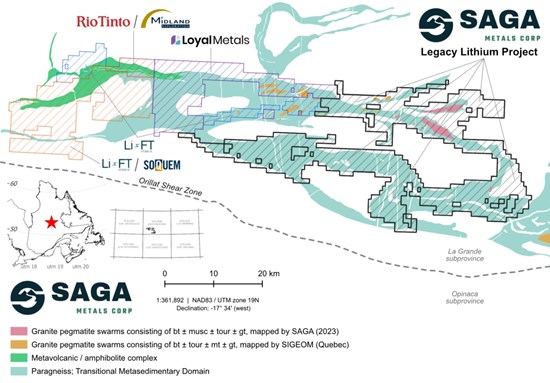


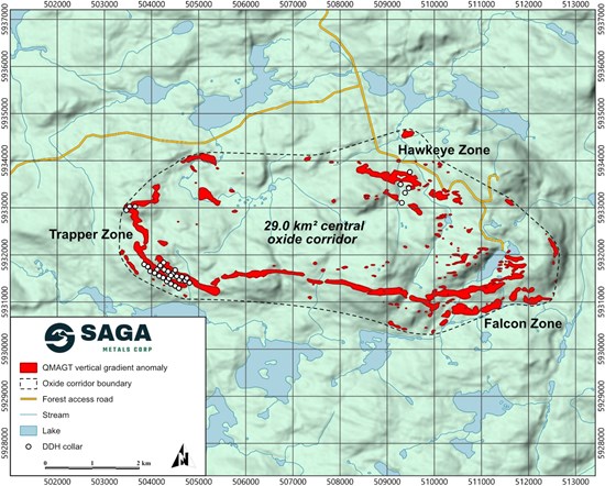

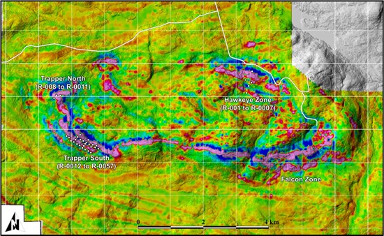
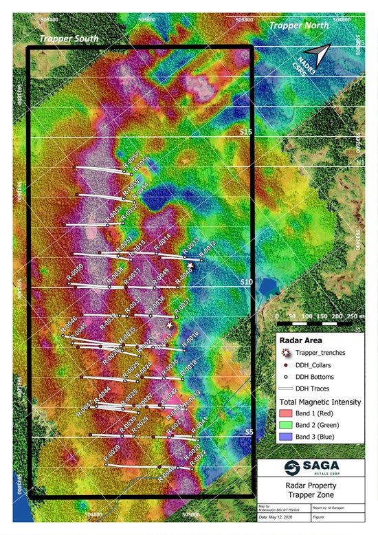
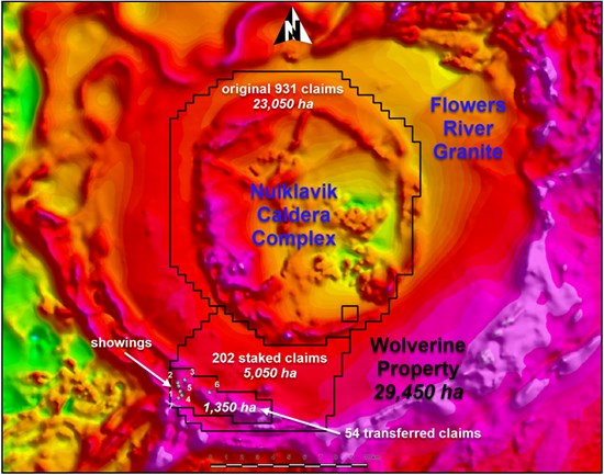
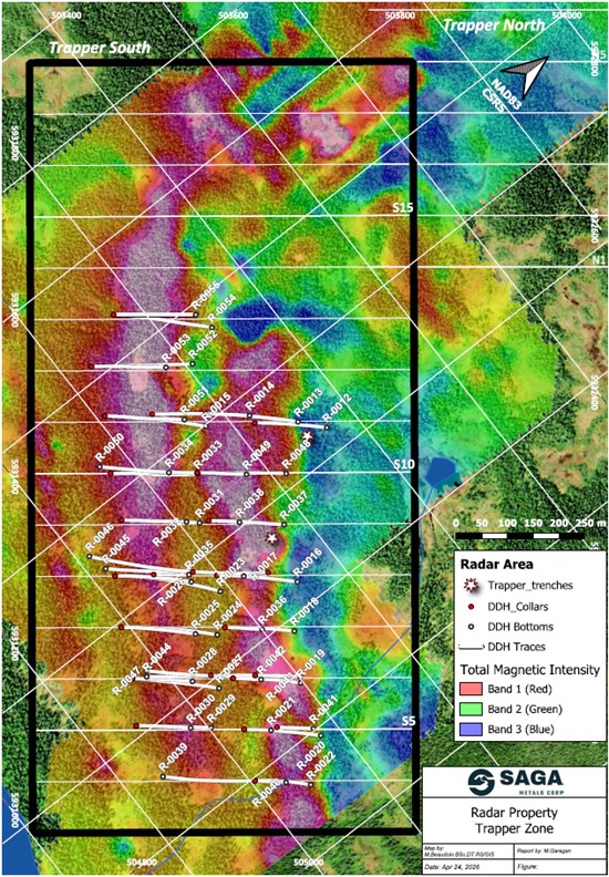
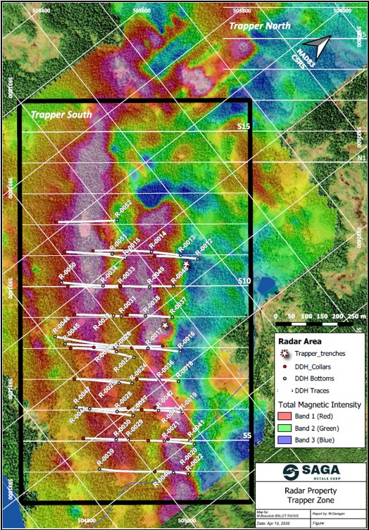

 Mr. Zen
3週前
Mr. Zen
3週前
 Oleblue
6月前
Oleblue
6月前
 aljafy
7月前
aljafy
7月前
 illegal_alias
7月前
illegal_alias
7月前
 メールアドレスで登録