Max Resource to Commence LiDAR
Survey Over the URU Project in NE Colombia
Vancouver B.C., December 2, 2021
-- InvestorsHub NewsWire -- MAX RESOURCE CORP. ("Max" or the
"Company") (TSX.V: MXR; OTC: MXROF; Frankfurt: M1D2) is
pleased to report that it has engaged DigitalWorld Mapping to
conduct an airborne high-resolution LiDAR survey over the entire
URU Zone within its wholly-owned CESAR project, Northeastern
Colombia (refer to Figures 1 to 4).
The LiDAR survey is part of the first steps to determining
high probability drill targets at URU.
The survey will consist of 600-line-km with 250m line spacing
covering approximately 290-km². LiDAR is a modern remote sensing
technique that concurrently takes high-resolution (hi-res) images
and builds a detailed digital terrain model (DTM) utilizing an
extremely sensitive and accurate digital mapping tool.
Together, the DTM and hi-res images provide
oathree-dimensional (3D) model of the terrain, where additional
data (geophysics, drilling, surface sampling, etc.) can be
incorporated to provide a multi-dimensional model from which
multiple data sources can be interpreted accurately, all in 3D. It
is a particularly powerful tool for drill planning as it
significantly reduces the risk of interpreting data in only two
dimensions.
"The LiDAR datasets will
be used for the URU Zone drill design and planning access and
provides unprecedented ground details to be observed for the first
time," commented Max CEO, Brett Matich.
"LiDAR assistance in
building an accurate 3D model will be key in maximizing the success
of Max's virgin drill program at
URU, being the first significant exploration event in the Cesar
basin since the discovery of Cerrejón, the largest coal mine in
South America and the basis for much of the critical infrastructure
in the Cesar basin," he continued.
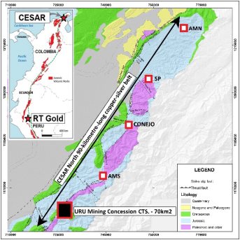
Figure 1: URU
location
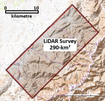
Figure 2. URU LiDAR
Survey 290-km²
Area
What is LiDAR?
LiDAR is the acronym for Light Detection and Ranging. It is a
relatively new active remote sensing technology using a laser
scanner, Global Positioning System (GPS), and inertial navigation.
In the same way that SONAR uses sound waves and reflection to
detect targets and determine distance (think of the ping heard in a
submarine scene from a war movie), LiDAR uses laser pulses with
their timed reflectance to determine the target distance. This
process is illustrated in Figure 3.
The standout feature of LiDAR is its ability to see the
ground through heavy vegetation. Repeat this process up to
1,000,000 times per second and you can quickly and accurately build
a point cloud of target reflections in 3D space, obtaining
information in areas where conventional topography, satellite
images or photogrammetry cannot reach.
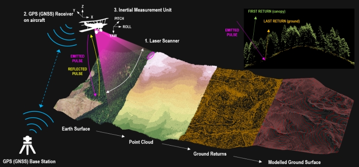
Figure 3: LIDAR
Process
QUALIFIED
PERSON
The Company's disclosure of a technical or scientific nature
in this news release has been reviewed and approved by Tim
Henneberry, P Geo (British Columbia), a member of the Max Resource
Advisory Board, who serves as a qualified person under the
definition of National Instrument 43:101.
CESAR
COPPER-SILVER PROJECT IN COLOMBIA – OVERVIEW
CESAR lies along the copper-silver rich 200-kilometre-long
Cesar Basin in northeastern Colombia. This region provides access
to major infrastructure (refer to Figure 4) resulting from oil
& gas and mining operations, including Cerrejón, the largest
coal mine in South America, now held by global miner
Glencore.
Geologically, Max interprets the URU sediment-hosted
stratiform copper-silver mineralization in the Cesar basin to be
analogous to both the Central African Copper Belt (CACB) and the
Kupferschiefer deposits in Poland.
Almost 50% of the copper known to exist in sediment-hosted
deposits is contained in the CACB, including Ivanhoe Mines Ltd
(TSX: IVN) 95-billion-pound Kamoa-Kakula discovery in the
Congo.
Kupferschiefer, the world's largest silver producer and
Europe's largest copper source, is a mining orebody ranging from
0.5 to 5.5m thick at depths of 500m, grading 1.49% copper and 48.6
g/t silver. The silver yield is almost twice the production of the
world's second largest silver mine.
Source: Central African Belt
Descriptive models, grade-tonnage relations, and databases for the
assessment of sediment-hosted copper deposits with emphasis on
deposits in the Central Africa Copperbelt, Democratic Republic of
the Congo and Zambia by USGS 2010. Kamoa-Kakula by OreWin March
2020. World Silver Survey 2020 and Kupferschiefer Deposits &
Prospects in SW Poland, September 27, 2019. Max cautions investors
that the presence of copper mineralization of the Central African
Copper Belt and the Polish Kupferschiefer are not necessarily
indicative of similar mineralization at CESAR.
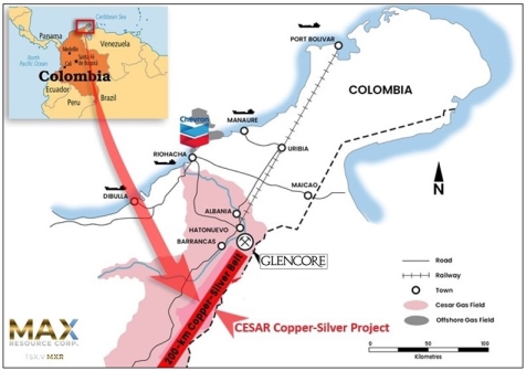
Figure 4: CESAR
project's world class infrastructure
CESAR North
90-kilometre-long-copper-silver belt:
-
Max discovered AMN (previously named AM North), collectively
spanning over 45-km², highlight values of 34.4% copper and 305 g/t
silver. Intervals range 0.5 to 25.0m
-
Max's CONEJO discovery (March 2021) is located now spans over
3.7-km of strike with average grade of 4.9% copper using 2% lower
cut. To date, 13 rock samples returned values greater than 8.0%
copper; 53 returned values greater than 5.0% copper; 93 returned
values 2.0% copper and above; 36 returned values greater than 20
g/t silver. Widths range from 0.5 to 20.0m. Highlight values of
12.5 % copper and 126 g/t
silver:
-
12.5% copper + 84 g/t silver over 5.0m by 5.0m
-
10.5% copper + 50 g/t silver over 3.0m by 2.0 m
-
10.4% copper + 95 g/t silver over 5.0m by 5.0m
-
10.2% copper + 62 g/t silver over 5.0m by 5.0m
-
10.0% copper + 80 g/t silver over 5.0m by 5.0m
-
9.9% copper and 50 g/t silver over widths of 2.0m
-
9.3% copper and 126 g/t silver over widths of 2.0m
-
The URU discovery (April 2021) is located 30-km south of
CONEJO, now expanded to 48-km² and open in all directions. URU
appears to have major-scale potential; Highlight values of 14.8%
copper and 132 g/t silver. Widths range 1.0 to 10.0m:
-
14.8% copper and 132 g/t silver outcrop over 1.5m x
0.8m
-
6.5% copper and 6 g/t silver outcrop over widths of
1.0m
-
5.6% copper and 87 g/t silver outcrop over 1.0m by
1.0m
-
4.3% copper and 8 g/t silver outcrop over widths of
10.0m
-
3.9% copper and 7 g/t silver outcrop over widths of
10.0m
-
3.6% copper and 12 g/t silver outcrop over widths of
10.0m
-
3.0% copper and 6 g/t silver outcrop over widths of
10.0m
-
3.0% copper and 37 g/t silver outcrop over widths of
10.0m
-
Recently granted four contagious Mining Concession Contracts
covering 70-km² of the URU target zone (November 24, 2021, NR)
-
The SP target is located within the mid portion of the CESAR
North 90-km-long-copper-silver belt, reconnaissance sampling over
25.0m averaged 4.8% copper and 51 g/t silver considered to be
significant (September 7,
2021, NR)
-
Next Steps:
-
Continue the CESAR copper-silver
regional exploration programs
-
LiDAR and infill mapping and
sampling of the entire 70-km²
-
Ground IP surveys to zero in on
drill targets
-
Environmental and socio-economic
surveys for drill permitting
-
Phase one drilling of the URU
delineated targets
ABOUT MAX
RESOURCE CORP.
Max Resource Corp. is a copper and precious metals
exploration company, engaged in advancing both the newly discovered
district-scale CESAR copper-silver project (100% owned) in Colombia
and the newly acquired RT Gold project (100% earn-in) in Peru. Both
projects have potential for the discovery of large-scale mineral
deposits; both stratiform-type copper-silver in Colombia and
high-grade gold porphyry and massive sulfide in Peru.
Max Resource was awarded a Top 10 Ranked Company in the
Mining Sector on the TSX Venture 50™ for 2021, achieving a market
cap increase of 1,992% and a share price increase of 282% in
2020.
For more information visit: https://www.maxresource.com/
For more information visit: www.tsx.com/venture50
TSX Venture 50™ for 2021 video: MAX Resource Corp.
(TSXV: MXR) - 2021 TSX Venture 50 - YouTube
For additional information contact:
Max Resource Corp. Hudes
Communications International
Tim McNulty Nelson
Hudes
E: info@maxresource.com
E:
nelson@hudescommunications.com
T: (604) 290-8100 Phone: (905)
660-9155
*The Venture 50 ranking is provided
by TSX Venture Exchange Inc. ("TSXV") for information purposes
only. Neither TMX Group Limited nor any of its
affiliated companies guarantees the completeness of this
information and are not responsible for any errors or omissions in
or any use of, or reliance on, this information. The Venture 50
program is not an invitation to purchase securities listed on TSX
Venture Exchange. TSXV and its affiliates do not endorse or
recommend any of the referenced securities or issuers, and this
information should not be construed as providing any trading,
legal, accounting, tax, investment, business, financial or other
advice and should not be relied on for such purposes"
Neither TSX Venture Exchange nor its
Regulation Services Provider (as that term is defined in the
policies of the TSX Venture Exchange) accepts responsibility for
the adequacy or accuracy of this release
Except for statements
of historic fact, this news release contains certain
"forward-looking information" within the meaning of applicable
securities law. Forward-looking information is
frequently characterized by words such as "plan", "expect",
"project", "intend", "believe", "anticipate", "estimate" and other
similar words, or statements that certain events or conditions
"may" or "will" occur. Forward-looking statements are
based on the opinions and estimates at the date the statements are
made and are subject to a variety of risks and uncertainties and
other factors that could cause actual events or results to differ
materially from those anticipated in the forward-looking statements
including, but not limited to delays or uncertainties with
regulatory approvals, including that of the TSXV. There are uncertainties inherent
in forward-looking information, including factors beyond the
Company's control. There are no assurances that the
commercialization plans for Max Resources Corp. described in this
news release will come into effect on the terms or time frame
described herein. The Company undertakes no
obligation to update forward-looking information if circumstances
or management's estimates or opinions should change except as
required by law. The reader is cautioned not to
place undue reliance on forward-looking statements. Additional information
identifying risks and uncertainties that could affect financial
results is contained in the Company's filings with Canadian
securities regulators, which filings are available at
www.sedar.com