Rocketred
5月前
Rocketred
5月前
Bonaparte could be HUGE 3000 x 2000 metre mag high anomaly they believe is the copper /gold porphyry source of the high grade gold veins in the discovery area pit
They just sampled in the summer of 2025
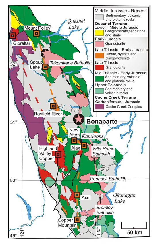
Decade Resources Ltd. has received assay results from sampling on the Bonaparte copper-gold property, located approximately 50 kilometres north of Kamloops, B.C., within the Kamloops mining division. The Bonaparte mineral claims are located on NTS map sheet 92I/16W and 92P/1W. There are two reported Minfile occurrences located on the property consisting of (Bonaparte 092 050) and (JS molybdenite 092INE178).
Highlights of the grab sampling program include:
1,662 grams per tonne Au (gold) and 0.88 per cent Cu (copper);
175.37 g/t Au and 2.267 per cent Cu;
82.3 g/t Au and 1.548 per cent Cu;
15.02 g/t Au and 5.902 per cent Cu
The property has different target areas including:
Cu/Au/Mo (molybdenum) porphyry potential;
Bulk-tonnage RIRGS target with high-grade gold results in historic drilling, trenching, underground exploration;
High-grade gold-copper veins.
Rocketred
5月前
AI numbers dimensions are 2000 m × 3000 m × 300 m thick (a large but thinner block compared to prior hypotheticals, still enormous for a porphyry Cu-Au deposit scenario).Volume = 2000 m × 3000 m × 300 m = 1,800,000,000 cubic meters (1.8 billion m³).
Total rock mass (using 2.7 tonnes per cubic meter density for typical solid in-place porphyry rock) = 1.8 billion m³ × 2.7 t/m³ = 4,860,000,000 metric tonnes (4.86 billion tonnes).
At 0.5% CuEq (copper equivalent grade), this represents the combined economic value of copper + gold (and minor others if present) expressed as if all were copper, based on metal prices, recoveries, etc.Total equivalent copper = 4,860,000,000 tonnes × 0.005 = 24,300,000 tonnes of CuEq.
Realistic Split for Cu and Au (Typical Porphyry Cu-Au at 0.5% CuEq)Current metal prices (late January 2026) are elevated: copper ˜ $5.90–$6.00 per pound (around $13,000/t), gold ˜ $5,100–$5,500 per ounce (very high, boosting gold's contribution to CuEq significantly compared to historical norms). In many recent porphyry reports, the CuEq formula gives roughly 0.5–0.7 × Au g/t equivalent to ~0.1% Cu (depending on exact prices/recoveries ~60–80% for Au vs. 85–90% for Cu).A balanced, typical split for a 0.5% CuEq porphyry Cu-Au deposit (gold-rich style, common in good examples):Copper: ~0.38% Cu (head grade, as gold often adds 20–40% of the equivalent value at these prices).Contained copper = 4,860,000,000 tonnes × 0.0038 ˜ 18.5 million tonnes of copper.
Gold: ~0.45 g/t Au (realistic for this CuEq level with high gold prices; e.g., 0.4–0.6 g/t range in many deposits).Contained gold = 4,860,000,000 tonnes × 0.00045 g/t = 2,187,000,000 grams = 2,187 tonnes of gold ˜ 70.3 million troy ounces (using 1 tonne = 32,150.75 oz).
Rocketred
5月前
Decade Resources samples 1,662 g/t Au in Bonaparte
2025-10-30 17:37 ET - News Release
Mr. Ed Kruchkowski reports
DECADE SAMPLES HIGH GOLD-COPPER ON THE BONAPARTE PROPERTY IN KAMLOOPS MINING DIVISION
Decade Resources Ltd. has received assay results from sampling on the Bonaparte copper-gold property, located approximately 50 kilometres north of Kamloops, B.C., within the Kamloops mining division. The Bonaparte mineral claims are located on NTS map sheet 92I/16W and 92P/1W. There are two reported Minfile occurrences located on the property consisting of (Bonaparte 092 050) and (JS molybdenite 092INE178).
Highlights of the grab sampling program include:
1,662 grams per tonne Au (gold) and 0.88 per cent Cu (copper);
175.37 g/t Au and 2.267 per cent Cu;
82.3 g/t Au and 1.548 per cent Cu;
15.02 g/t Au and 5.902 per cent Cu
The property has different target areas including:
Cu/Au/Mo (molybdenum) porphyry potential;
Bulk-tonnage RIRGS target with high-grade gold results in historic drilling, trenching, underground exploration;
High-grade gold-copper veins.
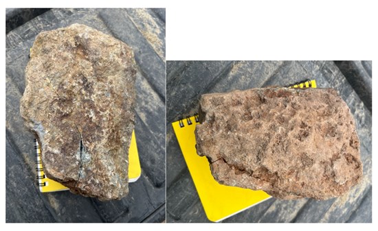
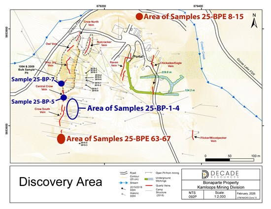
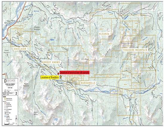
The main area of historic exploration for gold to date was called the Discovery area. This area is mineral occurrence (Minfile No. 092P 050) designated by Minfile as a developed prospect. Mineralization primarily occurs in a series of north-south-trending quartz veins hosted mainly by a quartz diorite intrusion. Locally, the quartz veins contain up to several per cent sulphides consisting of pyrite with lesser chalcopyrite, pyrrhotite and molybdenite. Native gold is also evident but generally is associated with silver-grey tellurides.
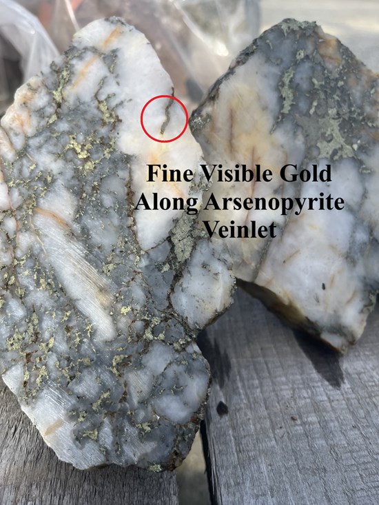
Quartz-sulphide from the Crow vein in the 1994 bulk sample area showing chalcopyrite with minor pyrite and fine visible gold. The white quartz is prior to the later grey sulphide-bearing quartz along fractures in the earlier material.
The sampling was conducted on exposed quartz-sulphide vein material in an open cut, the host quartz diorite intrusive as well as altered and horn-felsed argillite in the contact areas. In addition, samples were taken from 2018 unmarked and non-sampled drill core with quartz stringers piled near the portal, the decline muck material and quartz veining one kilometre east of the Discovery area.
 gsfl
14年前
gsfl
14年前
DDH-2012-3 Indicates 117.7 g/t Gold Over 2.13 m
Vancouver, BC - Decade Resources Ltd. (“Decade”) and Mountain Boy Minerals Ltd. (“Mountain Boy”) are providing an update on assays released in a June 5 press release for the Red Cliff project in Northwestern British Columbia. The joint venture project is owned 65% by Decade and 35% by Mountain Boy. The Red Cliff is a gold/copper property consisting of 8 Crown Granted mineral claims located 25 miles north of the town of Stewart, British Columbia. The Silver Crown 6 claim in which Decade is earning a 100 % interest is adjacent to the north portion of the crown grants. To date, the Companies have identified 3 separate gold bearing zones called the Upper Montrose, Lower Montrose and Waterpump within the Crown Granted claims.
In the assays released on June 5 a mineralized section in DDH-2012-3 was reported as 8.40 g/t gold over 4.26 m. The interval was recheck assayed using gravimetric methods due to the presence of coarse gold identified in the core during logging. The check assays indicated an increase from 9.69 g/t gold to 117.7 g/t over a 2.13 m interval. As a result the assay interval for the hole is now as follows:
In the future, any visible gold bearing sections will be analyzed using gravimetric methods.
All samples are assayed by Loring laboratories of Calgary, Alberta..It is an ISO9001 certified laboratory.
Ed. Kruchkowski, P. Geo., a qualified person under National Instrument 43-101, is in charge of the exploration program on behalf of the Companies and is responsible for the contents of this release. E Kruchkowski has conducted all the exploration on this property from 2007 to present and has logged and overseen the sampling of the core.
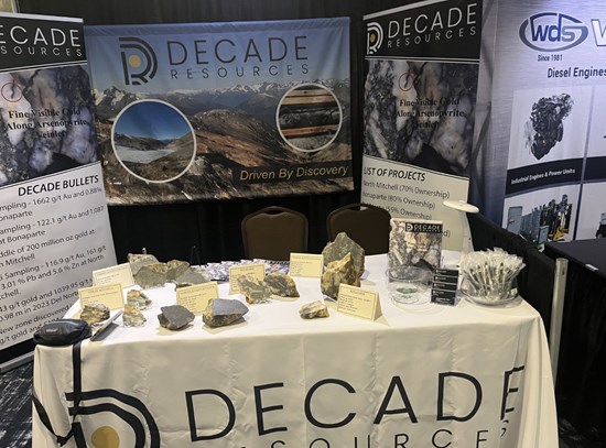
Decade Resources Ltd. is a Canadian based mineral exploration company actively seeking opportunities in the resource sector. Decade holds numerous properties at various stages of development and exploration from basic grass roots to advanced. Its properties and projects are primarily in Northern British Columbia. For a complete listing of the Company assets and developments, visit the Company website at www.decaderesources.ca.
gsfl
14年前
Visible Gold Intersected at Depth in Red Cliff Property Exploration
Vancouver, BC - Decade Resources Ltd. (“Decade”) and Mountain Boy Minerals Ltd. (“Mountain Boy”) are providing an update on the Red Cliff project in Northwestern British Columbia. The joint venture project is owned 65% by Decade and 35% by Mountain Boy. The Red Cliff is a gold/copper property consisting of 8 Crown Granted mineral claims located 25 miles north of the town of Stewart, British Columbia. High gold values are contained within stockwork zones that are composed of stringers of quartz-chalcopyrite-pyrite plus local coarse visible gold in the Upper Montrose zone over a 1 m section. These stringers have an envelope of galena-sphalerite-chalcopyrite stringers that contain local fine grained visible gold. To date, the Companies have identified 3 separate gold bearing zones called the Upper Montrose, Lower Montrose and Waterpump.
Since April 24, the companies have completed 12 holes all designed to test the Lower Montrose zone. Nine were completed along a panel from a pad created along the canyon wall approximately 40 m above the canyon floor and approximately 50 m NE of the exposed Lower Montrose zone. The first 3 holes encountered up to 15 m of stringer quartz-sulphide mineralization with local coarse visible gold in the third hole. See the Company website at www.decaderesources.ca or www. mountainboyminerals.ca. to view the photo of the gold. Holes 4 and 5 indicated that the zone was fault offset to the NE with sulphide mineralization ground up in the fault gouge. Holes 6 to 8 encountered the quartz - sulphide zones. Hole 9 indicated that a dyke had displaced the above mineral zone. The drill has been moved 100 m east to test an indicated zone exposed along the canyon wall that contained 50.39 g/t gold over 0.5 m within a partly exposed zone sampled in previous exploration. Three holes were completed in this location with the last hole being drilled to a depth of 596 m. The first hole deviated to the north and was terminated at 300m. The second hole drilled more southerly was lost in a fault at 480 m but encountered numerous sulphide bearing zones between 320 m to final depth. At approximately 300 m, narrow galena - sphalerite veinlets contain fine visible gold. Five samples taken on a random basis from 5 different sulphide zones at depth were rush assayed in order to guide the drilling of the 3rd hole in this area. Values ranged from a low of 47 ppb to a high of 2.2 g/t Au over 1.83 m with the highest value at the deepest sample site at 407 m. The other 3 samples assayed 0.4 g/t gold. Long sections of sulphide rich core remains to be cut and sampled in this hole. Based on the gold values in hole 11, the last hole on this panel was drilled to 596 m which was the power limitations of the drill. This hole encountered the galena veinlet bearing zone, the sulphide rich sections as seen in hole 11 as well as the depth extension of the Upper Montrose zone.
Drilling is continuing from pads just west of the first panel of holes once space is created. Upon completion of testing of the Lower Montrose zone, the companies plan to drill the Upper Montrose zone located along Lydden Creek.
gsfl
15年前
Decade Resources Ltd.: Step-Out Drilling Started on Upper Montrose Zone
VANCOUVER, BRITISH COLUMBIA--(Marketwire - Sept. 8, 2011) - Decade Resources Ltd. (TSX VENTURE:DEC) ("Decade" or the "Company") reports it has completed preliminary modeling of the high grade gold bearing Upper Montrose zone at its Red Cliff project in Northwestern British Columbia. The Red Cliff is a gold/copper property consisting of 8 Crown granted mineral claims located approximately 25 miles north of the town of Stewart, British Columbia. Access to the property is via drill roads off the paved highway 37A.
At Red Cliff, fine visible gold is associated with a stockwork of quartz-chalcopyrite-pyrite stringers occurring along a 30 metre wide shear zone. Strong disseminated and fracture filled pyrite mineralization as well as galena-sphalerite-chalcopyrite-visible gold form an envelope to the above stockwork mineralization.
Recent modeling indicates there are 2 different gold bearing zones rather than a single zone along the north side of Lydden Creek, as first thought. In addition, it has been determined that the upper Montrose Zone strikes southwest-northeast, dipping at shallow angles to the northwest, not striking to the northwest and dipping to the east as earlier interpreted. Indications are that several of the holes drilled in 2010 at Red Cliff were drilled parallel to or beneath the zone due to this early misinterpretation. Two plan maps outlining the previous and recent interpretations of the Montrose Zone have been added to the Company website.
To date, a total of 10 drill holes have been completed southwest of all previous drilling. Results of this drilling confirm the new interpretation that the zone does trend southwest-northeast and dips to the northwest. These holes have intersected wide zones of chalcopyrite and pyrite stringer mineralization with associated visible gold. Early results are expected with 10 days.
New modeling and the recent drilling confirms the upper Montrose zone is open along strike and down dip. The Company plans to continue drilling through the fall season and is considering adding a second drill.
Ed. Kruchkowski, P.Geo., a qualified person under National Instrument 43-101, is in charge of the exploration program on behalf of the Company. All samples are assayed by AGAT Laboratories of Mississauga, Ontario.
About Decade Resources:
Decade Resources Ltd. is a Canadian based mineral exploration company actively exploring its portfolio of projects in northern BC. The Company holds an extensive portfolio of exploration projects including: 60% interest in the Red Cliff property; an option to earn a 100% interest in the Silver Crown 6 claim, adjoining the Red Cliff property to the north; 100% interest in a large property underlain by copper-gold mineralization in the Kitimat area; claims located over the former Goat Mine, a small producer in the 1970's, approximately 34 kilometres northeast of Stewart and 5 kilometres north of the Stewart highway (37A) along the BA massive VMS horizon; 70% interest in the Stamp claims adjoining the BA claims hosting the BA massive VMS horizon; a large property just east of the former Premier mine underlain by copper-gold and silver base metal showings and a 50% interest in claims near the New Gold deposit at Blackwater.
ON BEHALF OF THE BOARD
Ed Kruchkowski, President
 Hot Features


 Renee
4年前
Renee
4年前

 メールアドレスで登録