CA Market News
2日前
CA Market News
2日前
CanAlaska Announces Senior Management ChangeJuly 8, 2026 7:30 AM
NewsfileNathan Bridge Resigns as Vice-President Exploration Following Completion of the Summer Drilling ProgramSaskatoon, Saskatchewan--(Newsfile Corp. - July 8, 2026) - CanAlaska Uranium Ltd. (TSXV: CVV) (OTCQX: CVVUF) (FSE: DH7) ("CanAlaska" or the "Company") is announcing changes to the Company's senior management team.CanAlaska is currently executing on its summer drill program where it is planning to complete 20 to 25 drill holes. Following the completion of the program, Nathan Bridge, current Vice-President Exploration, has resigned to pursue other interests. The Board of Directors and management wish to thank Mr. Bridge for his significant contributions, dedication and support to CanAlaska during his tenure and wish him well in his future endeavours. The Company will be conducting a search for a new Vice-President Exploration and Mr. Bridge has agreed to assist CanAlaska during this transition period. A further update will be provided in due course.CanAlaska CEO, Cory Belyk, comments, "Since 2021, Nathan and the executive team have worked side by side to build the CanAlaska team, expand the portfolio of high-quality exploration projects, focus the exploration effort, and discover a uranium deposit in the Athabasca Basin. Nathan has led the CanAlaska team toward that discovery from day one with an amazing skillset that balances the people with the money with the technical expertise. It has truly been a pleasure to work with Nathan for the past five years and I look forward to following his progress closely as he reaches for new career milestones. On behalf of the Board, I extend a very sincere thank you for all you have done to help build CanAlaska." CanAlaska Vice-President Exploration, Nathan Bridge, comments, "I am honoured to have served as the Vice-President Exploration at CanAlaska for the past five years. In that time, I've seen the Company grow significantly through the expansion of its high-quality uranium portfolio and the discovery of the Pike Zone. I am committed to working closely with the management team and Board of Directors to ensure that my transition is handled as efficiently as possible in support of the Company and its shareholders. I would like to thank the CanAlaska team, the Board of Directors, and the shareholders for their support over the last five years." About CanAlaska UraniumCanAlaska is a leading explorer of uranium in the Athabasca Basin of Saskatchewan, Canada. With a project generator model, the Company has built a large portfolio of uranium projects in the Athabasca Basin. CanAlaska owns numerous uranium properties, totaling approximately 330,000 hectares, with clearly defined targets in the Athabasca Basin covering both basement and unconformity uranium deposit potential. The Company has recently concentrated on the West McArthur high-grade uranium expansion with targets in 2024 and 2025 leading to significant success at Pike Zone. Fully financed for the 2026 drill season, CanAlaska is focused on uranium deposit discovery and delineation in a safe and secure jurisdiction. The Company has the right team in place with a track record of discovery and projects that are located next to critical mine and mill infrastructure.The Company's head office is in Saskatoon, Saskatchewan, Canada with a satellite office in Vancouver, BC, Canada.The Qualified Person under National Instrument 43-101 Standards of Disclosure for Mineral Projects for this news release is Nathan Bridge, MSc., P. Geo., Vice-President Exploration for CanAlaska Uranium Ltd., who has reviewed and approved its contents. On behalf of the Board of Directors
"Cory Belyk"
Cory Belyk, P.Geo., FGC
CEO, President and Director
CanAlaska Uranium Ltd.Contacts:Cory Belyk, CEO and PresidentGeneral EnquiryTel: +1.306.668.6900Tel: +1.306.668.6915Email: cbelyk@canalaska.comEmail: info@canalaska.com
Neither TSX Venture Exchange nor its Regulation Services Provider (as that term is defined in the policies of the TSX Venture Exchange) accepts responsibility for the adequacy or accuracy of this release. Forward-looking informationAll statements included in this press release that address activities, events or developments that the Company expects, believes or anticipates will or may occur in the future are forward-looking statements. Forward-looking statements are frequently identified by such words as "may", "will", "plan", "expect", "anticipate", "estimate", "intend" and similar words referring to future events and results. Forward-looking statements are based on the current opinions and expectations of management. These forward-looking statements involve numerous assumptions made by the Company based on its experience, perception of historical trends, current conditions, expected future developments and other factors it believes are appropriate in the circumstances. In addition, these statements involve substantial known and unknown risks and uncertainties that contribute to the possibility that the predictions, forecasts, projections and other forward-looking statements will prove inaccurate, certain of which are beyond the Company's control. Actual events or results may differ materially from those projected in the forward-looking statements and the Company cautions against placing undue reliance thereon. The Company believes that the expectations reflected in forward-looking statements included herein are reasonable, but no assurance can be given that these expectations will prove to be correct and such forward-looking statements included herein should not be unduly relied upon. These statements speak only as of the date hereof. The Company does not intend, and does not assume any obligation, to revise or update these forward-looking statements, except as required by applicable law.To view the source version of this press release, please visit https://www.newsfilecorp.com/release/304340 Original: CanAlaska Announces Senior Management Change
CA Market News
2週前
CanAlaska Announces Results from Key Extension Winter Drill ProgramJune 23, 2026 7:30 AM
NewsfileDrill Program Confirms Graphitic Fault Zone and Associated Hydrothermal AlterationResults Highlight Potential for Basement-Hosted Uranium MineralizationSaskatoon, Saskatchewan--(Newsfile Corp. - June 23, 2026) - CanAlaska Uranium Ltd. (TSXV: CVV) (OTCQX: CVVUF) (FSE: DH7) ("CanAlaska" or the "Company") is pleased to announce results from the winter drill program on its Key Extension project (the "Project") in the southeastern Athabasca Basin (Figure 1). The drill program focused on multiple high-priority target areas identified from recent airborne geophysical surveys and the results of historical drilling. During the program, the Company successfully confirmed the presence of strongly graphitic stratigraphy with re-activated semi-brittle basement fault zones containing associated hydrothermal alteration. The results from the drill program highlight the potential for discovery of basement-hosted uranium mineralization on the Project. The Key Extension project is 100% CanAlaska-owned and is located approximately 15 km southwest of the past-producing Key Lake Mine and current operating Key Lake Mill (Figure 1).Figure 1 – Project Location Map To view an enhanced version of this graphic, please visit:
https://images.newsfilecorp.com/files/2864/302477_6609c788e4886970_002full.jpgCanAlaska CEO, Cory Belyk, comments, "Early results from the Key Extension project are very good. The presence of graphitic fault zones with alteration, in places deep into the basement, are leading indicators of potential uranium-bearing fluids penetrating the right basement rocks. Basement-hosted uranium deposits like Eagle Point and Arrow can extend to depths reaching 1,000 metres below surface leaving abundant opportunity for significant uranium deposit discovery at depth on the Key Extension project. I look forward to the summer drilling program that is designed to test for the source of the nearby radioactive boulder train." 2026 Key Extension Exploration Drill ProgramThe 2026 winter drill program on the Key Extension project consisted of five diamond drill holes for a total of 1,251 metres in two target areas (Table 1; Figure 2). The program was focused on early-stage evaluation of a series of high-priority target areas identified based on the recent airborne geophysical surveys and the review of historical drilling. Results from the winter program on the Project are highlighted by the consistent intersection of graphitic stratigraphy containing re-activated graphitic fault zones with associated hydrothermal clay and chlorite alteration. Figure 2 – Key Extension Winter Drill Program Results To view an enhanced version of this graphic, please visit:
https://images.newsfilecorp.com/files/2864/302477_6609c788e4886970_004full.jpgDuring the drill program, two high-priority target areas were successfully tested: Follow Up on Historical Drilling: Three drillholes were completed to test conductive stratigraphy along strike of anomalous historical drillholes that contained a graphitic fault zone associated with clay, chlorite, and hematite alteration, and 487.3 ppm uranium over 0.15 m in drillhole KEY-001. KEY013, KEY014, and KEY015 successfully extended the strike length of the graphitic corridor in the target area. KEY014, which was the deepest test of the graphitic corridor, displayed the strongest chlorite and clay alteration associated with re-activated fault structures at depth (Figure 3). These results suggest that additional drilling in this target area should focus on testing deeper below surface on the conductive corridor for increasing hydrothermal alteration and the potential for basement-hosted uranium mineralization. Figure 3 – KEY014 Core PhotographTo view an enhanced version of this graphic, please visit:
https://images.newsfilecorp.com/files/2864/302477_6609c788e4886970_006full.jpgUp-Ice of the Orchid Lake Radioactive Boulder Field: Two drillholes were completed to test a series of conductive targets up-ice along the interpreted glacial ice direction of the historically reported Orchid Lake radioactive boulder field. KEY017 and KEY018 successfully intersected graphitic stratigraphy containing semi-brittle fault zones associated with localized chlorite and clay alteration. Results from the drillholes in this target area did not explain the source of the Orchid Lake radioactive boulder field. Additional drilling should be completed both closer to, and further along strike of, the conductive stratigraphy to continue to evaluate for the source of the Orchid Lake radioactive boulder field. Due to seasonal access challenges, the Company was unable to test several additional high-priority target areas on the Project including the Western Conductive Trend, the Eastern Conductive Trend, and drill targets more proximal to the Orchid Lake radioactive boulder field. The high-priority target areas on the Key Extension project remain focused on a series of long-linear magnetic low corridors associated with conductivity high corridors that are interpreted to extend from the Key Lake Mine and Mill complex area through the Company's Key Extension and Nebula projects. The magnetic lows with associated conductivity highs are interpreted to represent the graphitic metasedimentary rocks of the lower Wollaston Domain in the highly prospective Wollaston-Mudjatik transition zone. Drill targets on the Key Extension project within the graphitic metasedimentary package are focused on areas of interpreted structural complexity, where interpreted bends and breaks in the conductive rocks may create the potential for transport and trap of hydrothermal uranium-bearing mineralizing fluids. Next StepsThe Company is currently in the process of planning a helicopter-supported fall drill program on the Key Extension project. Priority targets for the planned program will be those that were inaccessible due to seasonal access challenges, including the Western Conductive Trend, the Eastern Conductive Trend, and drill targets more proximal to the Orchid Lake radioactive boulder field. The Company will provide details about the planned fall drilling program, which is anticipated to begin in September, in the coming weeks. Geochemical assay results from the winter drill program on the Key Extension project are pending. Table 1 – 2026 Winter Drill Hole Collar SummaryDrill HoleEasting NorthingElevation
(m A.S.L.)Azimuth
(°)Dip
(°)EOH
(m)KEY0134467506337731563324-74233KEY0144460166337431533335-75281KEY0154458176337458539350-75220KEY0174429726335906518300-70245KEY0184430206335565518255-68272Notes: Easting and Northing coordinates are reported in UTM Zone 13N (NAD83 datum). EOH = end of hole. m A.S.L. = metres above sea level. Technical Disclosure – Geochemical Assay Sampling Procedures, Historical Results, and Neighbouring PropertiesAll assay drill core samples from the program, completed as NQ-sized core, were shipped to the Saskatchewan Research Council Geoanalytical Laboratories (SRC) in Saskatoon, Saskatchewan in secure containment for preparation, processing, and multi-element analysis by ICP-MS and ICP-OES using total (HF:NHO3:HClO4) and partial digestion (HNO3:HCl), boron by fusion, and U3O8 wt% assay by ICP-OES using higher grade standards. Assay samples are chosen based on downhole probing radiometric equivalent uranium grades and scintillometer (SPP2 or CT007-M) peaks. Assay sample intervals comprise 0.3 – 0.8 metre continuous half-core split samples over the mineralized intervals. With all assay samples, one half of the split sample is retained and the other sent to the SRC for analysis. The SRC is an ISO/IEC 17025/2005 and Standards Council of Canada certified analytical laboratory. Blanks, standard reference materials, and repeats are inserted into the sample stream at regular intervals by CanAlaska and the SRC in accordance with CanAlaska's quality assurance/quality control (QA/QC) procedures. Geochemical assay data are subject to verification procedures by qualified persons employed by CanAlaska prior to disclosure.The historical results contained within this news release have been captured from the Saskatchewan Mineral Assessment Database (SMAD) as available and may be incomplete or subject to minor location inaccuracies. Management cautions that historical results collected and reported by past operators unrelated to CanAlaska have not been verified nor confirmed by a Qualified Person; however, the historical results form a scientific basis for ongoing work on the subject projects. Any historical rock / boulder samples are selective samples by nature and as such are not necessarily representative of the mineralization hosted across the property.This news release refers to neighbouring properties in which the Company has no interest. Results, discoveries, or mineralization on proximate land or neighboring properties, whether in stated current resource estimates or historical resource estimates, are not necessarily indicative of results, discoveries, or mineralization on the Company's properties. All reported depths and intervals are drill hole depths and intervals, unless otherwise noted, and do not represent true thicknesses, which have yet to be determined.About CanAlaska UraniumCanAlaska is a leading explorer of uranium in the Athabasca Basin of Saskatchewan, Canada. With a project generator model, the Company has built a large portfolio of uranium projects in the Athabasca Basin. CanAlaska owns numerous uranium properties, totaling approximately 330,000 hectares, with clearly defined targets in the Athabasca Basin covering both basement and unconformity uranium deposit potential. The Company has recently concentrated on the West McArthur high-grade uranium expansion with targets in 2024 and 2025 leading to significant success at Pike Zone. Fully financed for the 2026 drill season, CanAlaska is focused on uranium deposit discovery and delineation in a safe and secure jurisdiction. The Company has the right team in place with a track record of discovery and projects that are located next to critical mine and mill infrastructure.The Company's head office is in Saskatoon, Saskatchewan, Canada with a satellite office in Vancouver, BC, Canada.The Qualified Person under National Instrument 43-101 Standards of Disclosure for Mineral Projects for this news release is Nathan Bridge, MSc., P. Geo., Vice-President Exploration for CanAlaska Uranium Ltd., who has reviewed and approved its contents. On behalf of the Board of Directors
"Cory Belyk"
Cory Belyk, P.Geo., FGC
CEO, President and Director
CanAlaska Uranium Ltd.Contacts:Cory Belyk, CEO and PresidentGeneral EnquiryTel: +1.306.668.6900Tel: +1.306.668.6915Email: cbelyk@canalaska.comEmail: info@canalaska.com Neither TSX Venture Exchange nor its Regulation Services Provider (as that term is defined in the policies of the TSX Venture Exchange) accepts responsibility for the adequacy or accuracy of this release. Forward-looking informationAll statements included in this press release that address activities, events or developments that the Company expects, believes or anticipates will or may occur in the future are forward-looking statements. Forward-looking statements are frequently identified by such words as "may", "will", "plan", "expect", "anticipate", "estimate", "intend" and similar words referring to future events and results. Forward-looking statements are based on the current opinions and expectations of management. These forward-looking statements involve numerous assumptions made by the Company based on its experience, perception of historical trends, current conditions, expected future developments and other factors it believes are appropriate in the circumstances. In addition, these statements involve substantial known and unknown risks and uncertainties that contribute to the possibility that the predictions, forecasts, projections and other forward-looking statements will prove inaccurate, certain of which are beyond the Company's control. Actual events or results may differ materially from those projected in the forward-looking statements and the Company cautions against placing undue reliance thereon. The Company believes that the expectations reflected in forward-looking statements included herein are reasonable, but no assurance can be given that these expectations will prove to be correct and such forward-looking statements included herein should not be unduly relied upon. These statements speak only as of the date hereof. The Company does not intend, and does not assume any obligation, to revise or update these forward-looking statements, except as required by applicable law.To view the source version of this press release, please visit https://www.newsfilecorp.com/release/302477 Original: CanAlaska Announces Results from Key Extension Winter Drill Program
CA Market News
1月前
CanAlaska Begins Summer Drill Program at West McArthur Joint VentureJune 9, 2026 7:30 AM
NewsfileDrilling Focused on Continued Step Outs to Evaluate Trend for Additional Zones of High-Grade Uranium MineralizationAnticipate 20 to 25 Unconformity Target Tests in Fully Funded Summer ProgramSaskatoon, Saskatchewan--(Newsfile Corp. - June 9, 2026) - CanAlaska Uranium Ltd. (TSXV: CVV) (OTCQX: CVVUF) (FSE: DH7) ("CanAlaska" or the "Company") is pleased to announce the start of the summer drill program as part of the $15 million 2026 exploration program on the West McArthur Joint Venture Project (the "Project") in the southeastern Athabasca Basin (Figure 1). The 2026 West McArthur summer program will focus on continued step outs to the southwest and northeast of the currently defined high-grade mineralized footprint of the Pike Zone to evaluate for additional zones of high-grade uranium mineralization and continuation of the associated large hydrothermal alteration system. The West McArthur project, a Joint Venture with Cameco Corporation, is operated by CanAlaska which holds an 88.89% ownership in the Project. The 2026 exploration program is being co-funded by Cameco and CanAlaska under the Joint Venture.Figure 1 – Project Location Map To view an enhanced version of this graphic, please visit:
https://images.newsfilecorp.com/files/2864/300655_ea598cff64d98bbc_001full.jpgCanAlaska CEO, Cory Belyk, comments, "The winter exploration program at West McArthur's Pike Zone discovery highlighted extensive unconformity uranium mineralization in association with some very strong alteration and structure along the C10S corridor over more than 1,000 metres strike length. Some of the intersected and diagnostic alteration, specifically in the southwest direction, is among the strongest CanAlaska has encountered to date in the Pike Zone area. This is a clear indication of a continuing and strong mineralizing event that is focused at the unconformity. These encouraging results guide the plan for the summer drill targeting as the team continues to evaluate this area for additional high-grade uranium pods." Figure 2 – Drill Rigs on Site at the West McArthur Project. To view an enhanced version of this graphic, please visit:
https://images.newsfilecorp.com/files/2864/300655_ea598cff64d98bbc_003full.jpg2026 West McArthur Summer Exploration ProgramThe 2026 summer drill program on the West McArthur project will consist of three diamond drills operating to achieve an estimated 20 to 25 unconformity target intersections. The summer drill program will continue to build on results from the successful winter exploration program where the Company stepped out 350 metres southwest and 350 metres northeast from previous drilling, intersecting continued strong alteration, structure, graphitic host stratigraphy, and multiple drill fences with unconformity-associated and basement-hosted uranium mineralization (See News Release dated May 5, 2026). The primary focus for the summer program will be continued systematic testing to evaluate the C10S corridor for additional pods of high-grade uranium mineralization. Target areas are concentrated both to the southwest and northeast of the high-grade Pike Zone core. The drill program will focus on additional step-outs along the trend and infill testing of larger gaps along the trend where strong hydrothermal alteration and lower-grade uranium mineralization indicate the potential for additional pods (Figure 3). The Company will continue to utilize the recent geophysical survey results for targeting, which indicate interpreted structural complexity with sharp changes in orientation of the main conductor trend in the immediate four kilometres of strike length around the Pike Zone. Figure 3 – 2026 Summer Exploration Targets Along C10S Corridor To view an enhanced version of this graphic, please visit:
https://images.newsfilecorp.com/files/2864/300655_ea598cff64d98bbc_006full.jpgResults from recent drill programs on the Project have defined the hydrothermal system associated with the unconformity target area along the C10S corridor over 1.3 kilometres strike length, with over one kilometre strike length containing uranium mineralization. The target corridor remains sparsely tested over 530 metres strike length to the northeast and 630 metres strike length to the southwest from the 140-metre-long high-grade core of the Pike Zone. The results from recent drill programs show similar continued hydrothermal alteration intensity, styles, and types as those that are observed in direct association with the Pike Zone near the most significant high-grade intersections drilled to date. The Company believes that the recent positive drill program results coupled with the already proven uranium endowment of the C10 and C10S corridors highlights the significant potential for the discovery of additional unconformity-related high-grade zones of uranium mineralization. As a result, continued systematic evaluation for additional high-grade pods of unconformity-associated uranium mineralization in both directions along the C10S corridor is the main priority for the summer drill program. The Company expects to complete the summer portion of the 2026 exploration program in September. The geochemical assay results from the winter portion of the 2026 exploration program are pending.About CanAlaska UraniumCanAlaska is a leading explorer of uranium in the Athabasca Basin of Saskatchewan, Canada. With a project generator model, the Company has built a large portfolio of uranium projects in the Athabasca Basin. CanAlaska owns numerous uranium properties, totaling approximately 330,000 hectares, with clearly defined targets in the Athabasca Basin covering both basement and unconformity uranium deposit potential. The Company has recently concentrated on the West McArthur high-grade uranium expansion with targets in 2024 and 2025 leading to significant success at Pike Zone. Fully financed for the 2026 drill season, CanAlaska is focused on uranium deposit discovery and delineation in a safe and secure jurisdiction. The Company has the right team in place with a track record of discovery and projects that are located next to critical mine and mill infrastructure.The Company's head office is in Saskatoon, Saskatchewan, Canada with a satellite office in Vancouver, BC, Canada.The Qualified Person under National Instrument 43-101 Standards of Disclosure for Mineral Projects for this news release is Nathan Bridge, MSc., P. Geo., Vice-President Exploration for CanAlaska Uranium Ltd., who has reviewed and approved its contents. On behalf of the Board of Directors
"Cory Belyk"
Cory Belyk, P.Geo., FGC
CEO, President and Director
CanAlaska Uranium Ltd.Contacts:Cory Belyk, CEO and PresidentGeneral EnquiryTel: +1.306.668.6900Tel: +1.306.668.6915Email: cbelyk@canalaska.comEmail: info@canalaska.com Neither TSX Venture Exchange nor its Regulation Services Provider (as that term is defined in the policies of the TSX Venture Exchange) accepts responsibility for the adequacy or accuracy of this release. Forward-looking informationAll statements included in this press release that address activities, events or developments that the Company expects, believes or anticipates will or may occur in the future are forward-looking statements. Forward-looking statements are frequently identified by such words as "may", "will", "plan", "expect", "anticipate", "estimate", "intend" and similar words referring to future events and results. Forward-looking statements are based on the current opinions and expectations of management. These forward-looking statements involve numerous assumptions made by the Company based on its experience, perception of historical trends, current conditions, expected future developments and other factors it believes are appropriate in the circumstances. In addition, these statements involve substantial known and unknown risks and uncertainties that contribute to the possibility that the predictions, forecasts, projections and other forward-looking statements will prove inaccurate, certain of which are beyond the Company's control. Actual events or results may differ materially from those projected in the forward-looking statements and the Company cautions against placing undue reliance thereon. The Company believes that the expectations reflected in forward-looking statements included herein are reasonable, but no assurance can be given that these expectations will prove to be correct and such forward-looking statements included herein should not be unduly relied upon. These statements speak only as of the date hereof. The Company does not intend, and does not assume any obligation, to revise or update these forward-looking statements, except as required by applicable law.To view the source version of this press release, please visit https://www.newsfilecorp.com/release/300655 Original: CanAlaska Begins Summer Drill Program at West McArthur Joint Venture
CA Market News
1月前
CanAlaska Announces Results from Winter Geophysical Program on West McArthur ProjectMay 26, 2026 7:30 AM
NewsfileMultiple Strong Conductors Associated with Uranium and Clay Pathfinders Highlight New Exploration Target AreaOver 20 Kilometres of New Drill-Ready Conductor Targets IdentifiedSaskatoon, Saskatchewan--(Newsfile Corp. - May 26, 2026) - CanAlaska Uranium Ltd. (TSXV: CVV) (OTCQX: CVVUF) (FSE: DH7) ("CanAlaska" or the "Company") is pleased to report the results from the recently completed geophysical program on the West McArthur Joint Venture Project (the "Project") in the eastern Athabasca Basin (Figure 1). During the winter exploration program, the company completed a modern Stepwise Moving Loop Time Domain Electromagnetics (SWML-TDEM) survey on the Epp Lake Corridor. The goal of the survey was to map a historical ZTEM conductivity anomaly that is associated with a magnetic low corridor using high-resolution ground-based survey methods. The survey identified multiple strong conductors stacked within a broad magnetic low corridor. As a result of the winter geophysical survey and the historical drilling completed immediately to the north of the survey area, the Company believes that these newly generated conductor targets represent a significant opportunity for the discovery of high-grade unconformity uranium mineralization. Figure 1 – Project Location Map To view an enhanced version of this graphic, please visit:
https://images.newsfilecorp.com/files/2864/298784_73ea1c61341c6981_001full.jpgCanAlaska CEO, Cory Belyk, comments, "The identification of 20 kilometres of previously unknown and untested strong conductor targets on the West McArthur project in an area with nearby previously drilled uranium and clay pathfinder anomalism is a great outcome for the joint venture. The Epp Lake corridor has long been recognized as a strongly conductive graphitic-basement corridor in the eastern Athabasca Basin. The resolution and extension of this corridor on the West McArthur project provides another high priority set of drill-ready targets and discovery opportunity for future drill testing." CanAlaska VP Exploration, Nathan Bridge, comments, "The winter geophysical survey on the West McArthur project highlighted multiple kilometres of stacked strong conductor anomalies along the Epp Lake Corridor. Combined with the pathfinder anomalism in the historical drilling, the newly defined geophysical targets represent a significant discovery opportunity. The team is currently analyzing the new geophysical data with our historical knowledge to refine the best potential exploration targets in this target area. In addition, the team is working diligently to prepare for our upcoming summer drill program on the West McArthur project." Figure 2 – West McArthur Epp Lake Corridor Grid 1 Conductor Interpretation To view an enhanced version of this graphic, please visit:
https://images.newsfilecorp.com/files/2864/298784_73ea1c61341c6981_004full.jpg2026 West McArthur Winter Geophysical Program Results and Target GenerationThe 2026 winter geophysical program on the West McArthur project consisted of four survey lines totaling 78.0 km of SWML-TDEM surveying across the Epp Lake corridor. Historical work on this portion of the West McArthur project identified a broad ZTEM conductivity corridor associated with a magnetic low. The winter survey highlighted multiple strong northwest-dipping and southwest-trending conductors stacked within a broad magnetic low (Figure 2). In total, over 20 kilometres of new conductor strike length was identified during the survey. After the data collection, the Company completed Maxwell plate modelling of the conductive features which shows a strong association between the magnetic low corridor and the conductors. Generally, the conductors are strongest in the northern lines of the survey.Figure 3 – West McArthur Grid 1 Exploration Targets To view an enhanced version of this graphic, please visit:
https://images.newsfilecorp.com/files/2864/298784_73ea1c61341c6981_006full.jpgIn Athabasca unconformity-associated uranium deposits, sandstone alteration halos are typically defined by several key pathfinder elements including spectral clay identification of illite, dravite, and kaolinite, and geochemical pathfinder enrichment consisting of various metals including uranium, arsenic, cobalt, nickel, lead, and copper. Historically, in this portion of the project, 20 drillholes have been completed testing various targets along the Epp Lake Corridor. Along the northern edge of the winter geophysical survey area, several of these historical drillholes map a prominent lower sandstone illite anomaly that is associated with a broader pervasive uranium pathfinder halo (Figure 3). In addition, northeast/southwest-trending structural corridors in the Eastern Athabasca Basin are host to several prominent high-grade unconformity-associated uranium deposits including McArthur River, Phoenix, and the Eagle Point system1. As a result of the geophysical survey results and the pathfinder anomalies identified in the nearby historical drilling, the Company believes that these newly-mapped conductor targets are typical Athabasca Basin unconformity-associated uranium targets and represent a significant opportunity for the discovery of high-grade unconformity-associated uranium mineralization. The West McArthur project, a Joint Venture with Cameco Corporation, is operated by CanAlaska, which holds an 88.89% ownership in the Project. The 2026 exploration program is being co-funded by Cameco and CanAlaska under the Joint Venture.Technical Disclosure – Historical Results and Neighbouring PropertiesThe historical results contained within this news release have been captured from the Saskatchewan Mineral Assessment Database (SMAD) as available and may be incomplete or subject to minor location inaccuracies. Management cautions that historical results collected and reported by past operators unrelated to CanAlaska have not been verified nor confirmed by a Qualified Person; however, the historical results form a scientific basis for ongoing work on the subject projects. This news release refers to neighbouring properties in which the Company has no interest. Results, discoveries, or mineralization on proximate land or neighboring properties, whether in stated current resource estimates or historical resource estimates, are not necessarily indicative of results, discoveries, or mineralization on the Company's properties. ReferencesIAEA-TECDOC-1857. Unconformity-Related Uranium Deposits. 2018. About CanAlaska UraniumCanAlaska is a leading explorer of uranium in the Athabasca Basin of Saskatchewan, Canada. With a project generator model, the Company has built a large portfolio of uranium projects in the Athabasca Basin. CanAlaska owns numerous uranium properties, totaling approximately 340,000 hectares, with clearly defined targets in the Athabasca Basin covering both basement and unconformity uranium deposit potential. The Company has recently concentrated on the West McArthur high-grade uranium expansion with targets in 2024 and 2025 leading to significant success at Pike Zone. Fully financed for the 2026 drill season, CanAlaska is focused on uranium deposit discovery and delineation in a safe and secure jurisdiction. The Company has the right team in place with a track record of discovery and projects that are located next to critical mine and mill infrastructure.The Company's head office is in Saskatoon, Saskatchewan, Canada with a satellite office in Vancouver, BC, Canada.The Qualified Person under National Instrument 43-101 Standards of Disclosure for Mineral Projects for this news release is Nathan Bridge, MSc., P. Geo., Vice-President Exploration for CanAlaska Uranium Ltd., who has reviewed and approved its contents. On behalf of the Board of Directors
"Cory Belyk"
Cory Belyk, P.Geo., FGC
CEO, President and Director
CanAlaska Uranium Ltd.Contacts: Cory Belyk, CEO and PresidentGeneral EnquiryTel: +1.306.668.6900Tel: +1.306.668.6915Email: cbelyk@canalaska.comEmail: info@canalaska.com Neither TSX Venture Exchange nor its Regulation Services Provider (as that term is defined in the policies of the TSX Venture Exchange) accepts responsibility for the adequacy or accuracy of this release. Forward-looking informationAll statements included in this press release that address activities, events or developments that the Company expects, believes or anticipates will or may occur in the future are forward-looking statements. Forward-looking statements are frequently identified by such words as "may", "will", "plan", "expect", "anticipate", "estimate", "intend" and similar words referring to future events and results. Forward-looking statements are based on the current opinions and expectations of management. These forward-looking statements involve numerous assumptions made by the Company based on its experience, perception of historical trends, current conditions, expected future developments and other factors it believes are appropriate in the circumstances. In addition, these statements involve substantial known and unknown risks and uncertainties that contribute to the possibility that the predictions, forecasts, projections and other forward-looking statements will prove inaccurate, certain of which are beyond the Company's control. Actual events or results may differ materially from those projected in the forward-looking statements and the Company cautions against placing undue reliance thereon. The Company believes that the expectations reflected in forward-looking statements included herein are reasonable, but no assurance can be given that these expectations will prove to be correct and such forward-looking statements included herein should not be unduly relied upon. These statements speak only as of the date hereof. The Company does not intend, and does not assumes any obligation, to revise or update these forward-looking statements, except as required by applicable law.To view the source version of this press release, please visit https://www.newsfilecorp.com/release/298784 Original: CanAlaska Announces Results from Winter Geophysical Program on West McArthur Project
CA Market News
2月前
CanAlaska Announces Results from Winter Drill Program on West McArthur ProjectMay 5, 2026 7:30 AM
NewsfileHydrothermal System and Uranium Mineralization Extended Along Unconformity Target; Mineralization Now Over One Kilometre LengthParallel Faulted Graphitic Conductor Target Now Drill-ProvenSaskatoon, Saskatchewan--(Newsfile Corp. - May 5, 2026) - CanAlaska Uranium Ltd. (TSXV: CVV) (OTCQX: CVVUF) (FSE: DH7) ("CanAlaska" or the "Company") is pleased to report that it has completed the winter drill program at the Pike Zone on the West McArthur Joint Venture Project (the "Project") in the eastern Athabasca Basin (Figure 1). The winter program was focused on continued step outs to the southwest and northeast of the currently defined high-grade mineralized footprint of the Pike Zone. During the program, the Company successfully stepped out 350 metres west and 350 metres east from previous drilling, intersecting continued strong alteration, structure, graphitic host stratigraphy, and multiple drill fences with unconformity- associated and basement-hosted uranium mineralization. The continuation of the large-scale hydrothermal system along trend in both directions from the high-grade Pike Zone highlights the continued potential for additional pods of high-grade mineralization and the requirement for continued systematic evaluation in both directions along the C10S corridor. Figure 1 – Project Location MapTo view an enhanced version of this graphic, please visit:
https://images.newsfilecorp.com/files/2864/295888_0ecd01b0c42ce8c6_002full.jpgCanAlaska CEO, Cory Belyk, comments, "I am very pleased with outcomes from the winter exploration program on CanAlaska's Pike Zone discovery. The identification of unconformity-related uranium mineralization over one kilometre and remaining open along strike is an indication of continuity of the depositional processes of the Pike Zone. The intensity of alteration associated with this unconformity mineralization is strong, specifically to the southwest, which gives the team confidence to continue our systematic drill-testing approach looking for the next 'pearl' of high-grade uranium mineralization. With more than $30 million in the treasury, CanAlaska is fully funded for the planned three-drill summer program scheduled to commence in June." CanAlaska VP Exploration, Nathan Bridge, comments, "The Pike Zone hydrothermal system continues to display all the right indicators for its potential to host multiple pods of high-grade uranium mineralization. Through our winter program, we demonstrated continued evidence for strong alteration, multi-episodic post-Athabasca structure in the sandstone and basement, and uranium mineralization associated with the unconformity target as we stepped out from the high-grade core of the Pike Zone. The team is very encouraged that the hydrothermal system remains open and fertile along strike in both directions and are ready to get back to our methodical results-driven drill testing strategy in June." 2026 West McArthur Winter Drill ProgramThe 2026 winter drill program on the West McArthur project is now complete. The program consisted of 24 unconformity tests, 10 of which contained uranium mineralization. The primary objective of the winter program was continued step outs to the southwest and northeast of the currently defined high-grade mineralized footprint of the Pike Zone. The program was designed to continue evaluation for additional pods of high-grade uranium mineralization within the associated large hydrothermal alteration system. During the program, the Company successfully expanded the hydrothermal alteration footprint along the C10S corridor 350 metres to the southwest and 350 metres to the northeast from the 2025 summer drill program. The winter drill program was successful in identifying key structural controls and alteration vectors, including bleaching, clay, chlorite, and sooty pyrite associated with sandstone and basement fault structures at the unconformity along strike in both directions. In addition, the Company intersected uranium mineralization associated with these structures and alteration zones on multiple drill fences moving both to the northeast and southwest of the high-grade Pike Zone footprint, highlighting the continued potential for additional mineralized pods within the hydrothermal system (Figure 2). A significant result from the winter drill program is the discovery of new high-grade unconformity-associated uranium mineralization approximately 250 metres to the northeast of the high-grade Pike Zone core, highlighted by drillhole WMA101-02 which intersected 5.2 metres at 3.10% eU3O8 (see News Release dated March 2nd, 2026). As a result of the winter drill program, the hydrothermal system associated with the unconformity target area along the C10S corridor has now been defined over 1.3 kilometres strike length, with over one kilometre strike length containing uranium mineralization. The target corridor remains sparsely tested over 530 metres strike length to the northeast and 630 metres strike length to the southwest from the 140-metre-long high-grade core of the Pike Zone. The results from the winter drill program show similar continued hydrothermal alteration intensity, styles, and types as those that are observed in direct association with the Pike Zone near the most significant high-grade intersections drilled to date. The winter drill program highlights the requirement for continued systematic evaluation for additional high-grade pods of unconformity-associated uranium mineralization in both directions along the C10S corridor.Figure 2 – Winter Drill Program ResultsTo view an enhanced version of this graphic, please visit:
https://images.newsfilecorp.com/files/2864/295888_0ecd01b0c42ce8c6_004full.jpgAs a secondary goal, two drillholes were completed to evaluate stacked geophysical conductor anomalies identified from the 2025 geophysical survey directly to the south of the Pike Zone. These drillholes identified multiple stacked and faulted parallel graphitic packages associated with bleaching and chlorite alteration southeast of the Pike Zone. The Company is also pleased to announce that it has completed the ground-based electromagnetic survey to investigate the extension of the Epp Lake conductor on to the West McArthur Project (Figure 1). A modern Stepwise Moving Loop Time Domain Electromagnetics (SWML-TDEM) survey, using the same survey design that led to the discovery of the Pike Zone, was completed to advance this part of the West McArthur Project. Preliminary results from the geophysical survey have identified a series of stacked conductor anomalies in a northeasterly trend coincident with a regional magnetic low. The Company is currently working with Convolutions Geoscience to process the results of the survey and evaluate the next steps. The SWML-TDEM survey was completed by Abitibi Geophysics.As part of the approved $15 million 2026 exploration program and budget, a summer drilling program is planned. The Company will provide details about the planned summer drilling program, which is anticipated to begin in June, in the coming weeks. Geochemical assay results from the winter portion of the 2026 exploration program are pending. The West McArthur project, a Joint Venture with Cameco Corporation, is operated by CanAlaska, which holds an 88.89% ownership in the Project. The 2026 exploration program is being co-funded by Cameco and CanAlaska under the Joint Venture.Figure 3 – Strong Sandstone Alteration and Structure to the Northeast Along the C10S Corridor. Characterized by Strong Bleaching, Limonite, Clay Alteration, and Broken and Blocky Core with Associated Strong Quartz Dissolution Resulting in Locally Poor Core Recovery. Drillhole WMA103-02.To view an enhanced version of this graphic, please visit:
https://images.newsfilecorp.com/files/2864/295888_0ecd01b0c42ce8c6_006full.jpgDrillhole Details – Northeastern Step Outs from Pike ZoneDuring the winter exploration program, eleven drillholes were completed stepping out to the northeast from Pike Zone. Five drillholes in this target area contained uranium mineralization, three of which were previously reported (see Table 1, Table 2, and News Release dated March 2nd, 2026). The lower portion of the sandstone column of the drillholes in this target area is strongly bleached with associated limonite alteration. Fault zones in the lower sandstone are characterized by broken and blocky core associated with quartz dissolution resulting in locally poor core recovery (Figure 3). Near the unconformity contact between the sandstone and the basement, the mineralized drillholes have sooty pyrite alteration as a halo around the uranium mineralization. The basement of the drillholes in this target area is bleached, clay, and chlorite altered with frequent quartz-carbonate veins as a halo associated with the target graphitic stratigraphy and re-activated fault zones. WMA101-03 contains disseminated unconformity-associated and vein-controlled basement uranium mineralization. WMA101-06 contains vein-controlled basement uranium mineralization. The last drillhole completed during the program in this target area, WMA106, was located hanging wall to the intended target and confirmed continuity of the graphitic package and hydrothermal alteration at depth. Figure 4 – Strong Sandstone Alteration and Structure to the Southwest Along the C10S Corridor. Fault Zone with Broken and Blocky Core with Associated Strong Quartz Dissolution, Intervals of Clay Replacement and Alteration, Bleaching, and Intense Sooty Pyrite Alteration Resulting in Locally Poor Core Recovery. Drillhole WMA100-02.To view an enhanced version of this graphic, please visit:
https://images.newsfilecorp.com/files/2864/295888_0ecd01b0c42ce8c6_008full.jpgDrillhole Details – Southwestern Step Outs from Pike ZoneDuring the winter exploration program, eleven drillholes were completed stepping out to the southwest from Pike Zone. Five drillholes in this target area contained uranium mineralization, one of which was previously reported (see Table 1, Table 2, and News Release dated March 2nd, 2026). The lower portion of the sandstone column of the drillholes in this target area is strongly bleached with associated limonite alteration. Fault zones in the lower sandstone are characterized by broken and blocky core associated with quartz dissolution and strong clay replacement resulting in locally poor core recovery (Figures 4 & 5). Near the unconformity contact between the sandstone and the basement, the mineralized drillholes have sooty pyrite alteration as a halo around the uranium mineralization. The basement of the drillholes in this target area is bleached, clay, and chlorite altered with frequent quartz-carbonate veins as a halo associated with the target graphitic stratigraphy and re-activated fault zones. WMA098-04 contains disseminated unconformity-associated uranium mineralization. WMA100-03 and WMA105 contain vein-controlled basement uranium mineralization. WMA104 contains unconformity-associated uranium mineralization in an interval of lost core due to strong basal sandstone alteration. Figure 5 – Strong Sandstone and Basement Alteration and Structure to the Southwest Along the C10S Corridor. Sandstone Fault Zone with Broken and Blocky Core with Associated Strong Quartz Dissolution, Bleaching, and Intense Sooty Pyrite Alteration Resulting in Locally Poor Core Recovery. Basement Consists of Graphitic Pelite with Re-Activated Structure and Associated Chlorite, Clay, Bleaching, and Quartz-Carbonate Alteration. Drillhole WMA104-01.To view an enhanced version of this graphic, please visit:
https://images.newsfilecorp.com/files/2864/295888_0ecd01b0c42ce8c6_010full.jpgDrillhole Details – Hanging Wall Conductor Test Around Pike ZoneDuring the winter program, two drillholes were completed to evaluate the stacked geophysical conductor anomalies identified from the 2025 geophysical survey across strike directly to the south of the Pike Zone, one of which was previously reported (see News Release dated March 2nd, 2026). WMA102 intersected a hanging wall graphitic package with a fault 140 metres below the unconformity contact. The surrounding pelitic rocks are chloritized and bleached with frequent quartz-carbonate veins. WMA078, which was a follow up to WMA102, intersected alteration and structure in the lower portion of the sandstone column followed by multiple re-activated graphitic fault zones in the basement. The drillholes in this target area identified multiple stacked and faulted graphitic packages associated with bleaching and chlorite alteration south of the Pike Zone that upgrade the stacked geophysical conductor anomaly targets along strike on the trend. Table 1 – Radiometric Equivalent Uranium GradesDDHFrom
(m)To
(m)Length
(m)7Average Grade
(% eU3O8)8WMA098-041,6813.8814.30.50.20
WMA100-032,6832.5832.80.30.19
WMA101-033,6822.4823.71.30.15WMA101-033,6825.6826.30.70.27
WMA101-063,6826.0827.31.30.16
WMA1044,6829.3830.20.90.28
WMA1055,6830.5830.70.20.14WMA098-04 was drilled at an azimuth of 310° with an inclination of -75.0°, collared at 477,106 m E / 6,396,389 m N, 606 m A.S.L. (UTM NAD83 Z13N) as a daughter hole from WMA098. WMA098-04 intersected the unconformity at 817.2 metres.WMA100-03 was drilled at an azimuth of 280° with an inclination of -76.0°, collared at 477,041 m E / 6,396,364 m N, 607 m A.S.L. (UTM NAD83 Z13N) as a daughter hole from WMA100. WMA100-03 intersected the unconformity at 830.8 metres.WMA101-03 and WMA101-06 were drilled at an azimuth of 320° with an inclination of -76.0°, collared at 477,603 m E / 6,396,666 m N, 597 m A.S.L. (UTM NAD83 Z13N) as daughter holes from WMA101. WMA101-03 intersected the unconformity at 821.0 metres, and WMA101-06 at 821.3 metres.WMA104 was drilled at an azimuth of 280° with an inclination of -76.0°, collared at 476,864 m E / 6,396,259 m N, 612 m A.S.L. (UTM NAD83 Z13N) as a pilot hole. WMA104 intersected the unconformity at 830.2 metres.WMA105 was drilled at an azimuth of 300° with an inclination of -79.0°, collared at 476,742 m E / 6,396,136 m N, 609 m A.S.L. (UTM NAD83 Z13N) as a pilot hole. WMA105 intersected the unconformity at 831.1 metres.Intersection interval is composited above a cut-off grade of 0.1% eU3O8 with a maximum of 1.0 m of internal dilution.All reported depths and intervals are drill hole depths and intervals, unless otherwise noted, and do not represent true thicknesses, which have yet to be determined.Radiometric equivalent ("eU3O8") derived from a calibrated gamma downhole probe. Table 2 – Previously Reported Radiometric Equivalent Uranium Grades (See News Release Dated March 2nd, 2026) DDHFrom
(m)To
(m)Length
(m)4Average Grade
(% eU3O8)5WMA1011,3823.2823.50.30.23WMA1011,3827.0828.41.40.27
WMA101-011,3823.2823.70.50.34
WMA101-021,3812.1817.35.23.10WMA101-021,3818.5819.00.50.86WMA101-021,3821.9822.30.411.76
WMA100-022,3831.6831.80.20.14WMA100-022,3832.8833.20.40.38WMA101, WMA101-01, and WMA101-02 were drilled at an azimuth of 320° with an inclination of -76.0°, collared at 477,603 m E / 6,396,666 m N, 597 m A.S.L. (UTM NAD83 Z13N) as a pilot hole and subsequent daughter holes from WMA101. WMA101 intersected the unconformity at 814.6 metres, WMA101-01 at 816.7 metres, and WMA101-02 at 817.5 metres.WMA100-02 was drilled at an azimuth of 280° with an inclination of -76.0°, collared at 477,041 m E / 6,396,364 m N, 607 m A.S.L. (UTM NAD83 Z13N) as a daughter hole from WMA100. WMA100-02 intersected the unconformity at 831.7 metres.Intersection interval is composited above a cut-off grade of 0.1% eU3O8 with a maximum of 1.0 m of internal dilution.All reported depths and intervals are drill hole depths and intervals, unless otherwise noted, and do not represent true thicknesses, which have yet to be determined.Radiometric equivalent ("eU3O8") derived from a calibrated gamma downhole probe. Technical Disclosure – Use of Radiometric Equivalent Grades and Geochemical Assay Sampling ProceduresDuring active exploration programs drillholes are radiometrically logged using calibrated downhole GeoVista NGRS and TGGS (Triple GM) gamma probes which collect continuous readings along the length of the drillhole wall. Downhole logging is not a direct measurement of the recovered core and represents the wall rock material of the drillhole. Preliminary radiometric equivalent uranium grades ("eU3O8") are then calculated from the downhole radiometric results. The probe is calibrated using an in-house algorithm calculated from the calibration of the probe at the Saskatchewan Research Council facility in Saskatoon and from the comparison of probe results against previously reported geochemical analyses. At extremely high radiometric equivalent uranium grades, downhole gamma probes may become saturated, resulting in the probe being overwhelmed, which in turn can create difficulties in accurately determining extremely high-grade radiometric equivalent uranium grades, and a cap may be applied to the grade. The equivalent uranium grades are preliminary and are subsequently reported as definitive assay grades following sampling and chemical analysis of the mineralized drill core. In the case where core recovery within a mineralized intersection is poor or non-existent, radiometric grades are considered to be more representative of the mineralized intersection and may be reported in the place of assay grades. Radiometric equivalent probe results are subject to verification procedures by qualified persons employed by CanAlaska prior to disclosure. All assay drill core samples from the program, completed as NQ-sized core, were shipped to the Saskatchewan Research Council Geoanalytical Laboratories (SRC) in Saskatoon, Saskatchewan in secure containment for preparation, processing, and multi-element analysis by ICP-MS and ICP-OES using total (HF:NHO3:HClO4) and partial digestion (HNO3:HCl), boron by fusion, and U3O8 wt% assay by ICP-OES using higher grade standards. Assay samples are chosen based on downhole probing radiometric equivalent uranium grades and scintillometer (SPP2 or CT007-M) peaks. Assay sample intervals comprise 0.3 – 0.8 metre continuous half-core split samples over the mineralized intervals. With all assay samples, one half of the split sample is retained and the other sent to the SRC for analysis. The SRC is an ISO/IEC 17025/2005 and Standards Council of Canada certified analytical laboratory. Blanks, standard reference materials, and repeats are inserted into the sample stream at regular intervals by CanAlaska and the SRC in accordance with CanAlaska's quality assurance/quality control (QA/QC) procedures. Geochemical assay data are subject to verification procedures by qualified persons employed by CanAlaska prior to disclosure.All reported depths and intervals are drill hole depths and intervals, unless otherwise noted, and do not represent true thicknesses, which have yet to be determined.About CanAlaska UraniumCanAlaska is a leading explorer of uranium in the Athabasca Basin of Saskatchewan, Canada. With a project generator model, the Company has built a large portfolio of uranium projects in the Athabasca Basin. CanAlaska owns numerous uranium properties, totaling approximately 500,000 hectares, with clearly defined targets in the Athabasca Basin covering both basement and unconformity uranium deposit potential. The Company has recently concentrated on the West McArthur high-grade uranium expansion with targets in 2024 and 2025 leading to significant success at Pike Zone. Fully financed for the 2026 drill season, CanAlaska is focused on uranium deposit discovery and delineation in a safe and secure jurisdiction. The Company has the right team in place with a track record of discovery and projects that are located next to critical mine and mill infrastructure.The Company's head office is in Saskatoon, Saskatchewan, Canada with a satellite office in Vancouver, BC, Canada.The Qualified Person under National Instrument 43-101 Standards of Disclosure for Mineral Projects for this news release is Nathan Bridge, MSc., P. Geo., Vice-President Exploration for CanAlaska Uranium Ltd., who has reviewed and approved its contents. On behalf of the Board of Directors
"Cory Belyk"
Cory Belyk, P.Geo., FGC
CEO, President and Director
CanAlaska Uranium Ltd.Contacts:Cory Belyk, CEO and PresidentGeneral EnquiryTel: +1.306.668.6900Tel: +1.306.668.6915Email: cbelyk@canalaska.comEmail: info@canalaska.com Neither TSX Venture Exchange nor its Regulation Services Provider (as that term is defined in the policies of the TSX Venture Exchange) accepts responsibility for the adequacy or accuracy of this release. Forward-looking informationAll statements included in this press release that address activities, events or developments that the Company expects, believes or anticipates will or may occur in the future are forward-looking statements. Forward-looking statements are frequently identified by such words as "may", "will", "plan", "expect", "anticipate", "estimate", "intend" and similar words referring to future events and results. Forward-looking statements are based on the current opinions and expectations of management. These forward-looking statements involve numerous assumptions made by the Company based on its experience, perception of historical trends, current conditions, expected future developments and other factors it believes are appropriate in the circumstances. In addition, these statements involve substantial known and unknown risks and uncertainties that contribute to the possibility that the predictions, forecasts, projections and other forward-looking statements will prove inaccurate, certain of which are beyond the Company's control. Actual events or results may differ materially from those projected in the forward-looking statements and the Company cautions against placing undue reliance thereon. The Company believes that the expectations reflected in forward-looking statements included herein are reasonable, but no assurance can be given that these expectations will prove to be correct and such forward-looking statements included herein should not be unduly relied upon. These statements speak only as of the date hereof. The Company does not intend, and does not assumes any obligation, to revise or update these forward-looking statements, except as required by applicable law.To view the source version of this press release, please visit https://www.newsfilecorp.com/release/295888 Original: CanAlaska Announces Results from Winter Drill Program on West McArthur Project
CA Market News
3月前
CanAlaska Uranium Ltd. Announces Board ChangeApril 2, 2026 7:30 AM
NewsfileAmbassador Thomas Graham Jr. to Retire from the BoardSaskatoon, Saskatchewan--(Newsfile Corp. - April 2, 2026) - CanAlaska Uranium Ltd. (TSXV: CVV) (OTCQX: CVVUF) (FSE: DH7) ("CanAlaska" or the "Company") announces that effective immediately, Ambassador Graham Jr. has elected to retire from the Board of CanAlaska Uranium Ltd. and will remain connected to CanAlaska with the continuing designation of Chair Emeritus.Ambassador Graham Jr. has been a long-standing member of CanAlaska's Board for almost two decades. He served on various committees throughout his tenure since 2007, and as Chair from 2011 to 2024. Ambassador Thomas Graham, Jr. is one of the world's leading experts in nuclear non-proliferation. Amb. Graham Jr. has served under four successive U.S. Presidents as a senior U.S. diplomat involved in the negotiation of every major international arms control and non-proliferation agreement during that time. This includes the SALT, START, ABM, INF, NPT, CFE and CTBT Treaties. Amb. Graham Jr. has served with the U.S. Arms Control and Disarmament Agency and as the Special Representative of the President of the United States for Arms Control, Non-Proliferation, and Disarmament, in which role he successfully led U.S. government efforts to achieve the permanent extension of the Nuclear Non-Proliferation Treaty. He was appointed as a member of the International Advisory Board for the nuclear program of the United Arab Emirates in December 2009 and was Executive Chairman of Lightbridge Corporation, formerly Thorium Power, Ltd. (2006 - 2024) and is currently serving as Chairman of the Board of Mexco Energy Corporation (July 1997 - present)."My years with CanAlaska, about two decades, were most rewarding both professionally and personally. A great company with outstanding people, most effective in pursuing their mission," said Ambassador Thomas Graham Jr., Chair Emeritus of CanAlaska."On behalf of the CanAlaska Board, I extend sincere gratitude and appreciation for the stewardship and guidance that Tom provided to the Company throughout his 19 years with CanAlaska. Tom's extensive board governance background and insights relating to non-proliferation were an asset to management, the Company and Board throughout his tenure. Friendships will endure long after his service has ended. Tom will maintain the honorary title of Chair Emeritus in recognition of the role he played to shape the Company and its future," said Karen Lloyd, Chair of CanAlaska."Once again, I take the opportunity to thank Amb. Graham Jr. for his nearly two decades of work with CanAlaska. With Tom's guidance, CanAlaska has been built, maintained through challenging times, and emerged stronger than ever. CanAlaska's future success will be in part to Tom's effort at the Board level. Thank you, Tom," said Cory Belyk, CEO of CanAlaska.About CanAlaska UraniumCanAlaska is a leading explorer of uranium in the Athabasca Basin of Saskatchewan, Canada. With a project generator model, the Company has built a large portfolio of uranium projects in the Athabasca Basin. CanAlaska owns numerous uranium properties, totaling approximately 500,000 hectares, with clearly defined targets in the Athabasca Basin covering both basement and unconformity uranium deposit potential. The Company has recently concentrated on the West McArthur high-grade uranium expansion with targets in 2024 and 2025 leading to significant success at Pike Zone. Fully financed for the 2026 drill season, CanAlaska is focused on uranium deposit discovery and delineation in a safe and secure jurisdiction. The Company has the right team in place with a track record of discovery and projects that are located next to critical mine and mill infrastructure.The Company's head office is in Saskatoon, Saskatchewan, Canada with a satellite office in Vancouver, BC, Canada.The Qualified Person under National Instrument 43-101 Standards of Disclosure for Mineral Projects for this news release is Nathan Bridge, MSc., P. Geo., Vice-President Exploration for CanAlaska Uranium Ltd., who has reviewed and approved its contents. On behalf of the Board of Directors
"Cory Belyk"
Cory Belyk, P.Geo., FGC
CEO, President and Director
CanAlaska Uranium Ltd.Contacts:Cory Belyk, CEO and PresidentGeneral EnquiryTel: +1.306.668.6900Tel: +1.306.668.6915Email: cbelyk@canalaska.comEmail: info@canalaska.com Neither TSX Venture Exchange nor its Regulation Services Provider (as that term is defined in the policies of the TSX Venture Exchange) accepts responsibility for the adequacy or accuracy of this release. Forward-looking informationAll statements included in this press release that address activities, events or developments that the Company expects, believes or anticipates will or may occur in the future are forward-looking statements. Forward-looking statements are frequently identified by such words as "may", "will", "plan", "expect", "anticipate", "estimate", "intend" and similar words referring to future events and results. Forward-looking statements are based on the current opinions and expectations of management. These forward-looking statements involve numerous assumptions made by the Company based on its experience, perception of historical trends, current conditions, expected future developments and other factors it believes are appropriate in the circumstances. In addition, these statements involve substantial known and unknown risks and uncertainties that contribute to the possibility that the predictions, forecasts, projections and other forward-looking statements will prove inaccurate, certain of which are beyond the Company's control. Actual events or results may differ materially from those projected in the forward-looking statements and the Company cautions against placing undue reliance thereon. The Company believes that the expectations reflected in forward-looking statements included herein are reasonable, but no assurance can be given that these expectations will prove to be correct and such forward-looking statements included herein should not be unduly relied upon. These statements speak only as of the date hereof. The Company does not intend, and does not assumes any obligation, to revise or update these forward-looking statements, except as required by applicable law.To view the source version of this press release, please visit https://www.newsfilecorp.com/release/290939
Original: CanAlaska Uranium Ltd. Announces Board Change
CA Market News
4月前
CanAlaska Executes Exploration Agreement with Kineepik Métis Local Inc.March 24, 2026 7:30 AM
NewsfileAgreement Provides for a Sustainable Future for CanAlaska and Communities Near its Projects in the Athabasca BasinSaskatoon, Saskatchewan--(Newsfile Corp. - March 24, 2026) - CanAlaska Uranium Ltd. (TSXV: CVV) (OTCQX: CVVUF) (FSE: DH7) ("CanAlaska" or the "Company") is pleased to announce it has signed an exploration agreement with Kineepik Métis Local Inc. ("KML") to strengthen their relationship.With extensive land holdings, roughly 500,000 hectares (1,235,000 acres) and uranium exploration targets in Saskatchewan's Athabasca Basin some of which are in the traditional lands of KML territories, CanAlaska is dedicated to building a sustainable future for its company and the communities near which it explores. By entering into this agreement, CanAlaska is demonstrating this commitment. Similarly, KML seeks to work collaboratively with exploration and mining companies operating within its territory. As such, this agreement is founded on KML's commitment to ensuring the continued protection of their home while exercising their duty to ensure the ethical harvesting of resources throughout that home. "Kineepik Métis Local have signed an Exploration Agreement with CanAlaska to ensure that we are always included in the process of development. These agreements ensure that we are involved in the exploration that continues to impact our communities. We have many opportunities to monitor the environmental impacts, gain meaningful employment, expanding our community businesses and allows our communities to improve life for all residents by being a part of the process," said Mike Natomagan, President, Kineepik Métis Local Inc."As a leading explorer and generator of uranium projects in the Athabasca Basin, we value the strength that working in partnership with the people of Kineepik brings to our exploration activities in Saskatchewan. In turn, by signing this agreement and engaging in respectful and meaningful ways with Kineepik, we are proud to be able to contribute to their stewardship of the land," said Cory Belyk, CEO of CanAlaska.About Kineepik Métis Local Inc.The Northern Village of Pinehouse (NVP) is located within the traditional land and occupancy area of the Indigenous people of Kineepik Métis Local (KML). The lands surrounding the Missinippi (Churchill River) watershed have supported the gathering of food, shelter, and essential materials since time immemorial.As a result of the strong, collaborative relationship between KML and NVP, residents routinely benefit from significant employment and business opportunities associated with projects occurring within KML territory. Our community takes great pride in the work ethic of KML and NVP citizens, who consistently contribute to the wellbeing of both the community and the province.Through community-owned businesses, local profits have been reinvested into priority projects such as energy-efficient housing, youth infrastructure including the community hockey arena, and a 12-unit Elders' housing facility, demonstrating our commitment to building a strong, sustainable future.On behalf of the Board of Directors
"Mike Natomagan"
Mike Natomagan
President
Kineepik Métis LocalContacts:
Rosalena Smith, Executive Director
Tel: +1.306.884.0001
Email: rsmith@kineepik.caAbout CanAlaska UraniumCanAlaska is a leading explorer of uranium in the Athabasca Basin of Saskatchewan, Canada. With a project generator model, the Company has built a large portfolio of uranium projects in the Athabasca Basin. CanAlaska owns numerous uranium properties, totaling approximately 500,000 hectares, with clearly defined targets in the Athabasca Basin covering both basement and unconformity uranium deposit potential. The Company has recently concentrated on the West McArthur high-grade uranium expansion with targets in 2024 and 2025 leading to significant success at Pike Zone. Fully financed for the 2026 drill season, CanAlaska is focused on uranium deposit discovery and delineation in a safe and secure jurisdiction. The Company has the right team in place with a track record of discovery and projects that are located next to critical mine and mill infrastructure.The Company's head office is in Saskatoon, Saskatchewan, Canada with a satellite office in Vancouver, BC, Canada.The Qualified Person under National Instrument 43-101 Standards of Disclosure for Mineral Projects for this news release is Nathan Bridge, MSc., P. Geo., Vice-President Exploration for CanAlaska Uranium Ltd., who has reviewed and approved its contents. On behalf of the Board of Directors
"Cory Belyk"
Cory Belyk, P.Geo., FGC
CEO, President and Director
CanAlaska Uranium Ltd.Contacts:Cory Belyk, CEO and PresidentGeneral EnquiryTel: +1.306.668.6900Tel: +1.306.668.6915Email: cbelyk@canalaska.comEmail: info@canalaska.com Neither TSX Venture Exchange nor its Regulation Services Provider (as that term is defined in the policies of the TSX Venture Exchange) accepts responsibility for the adequacy or accuracy of this release. Forward-looking informationAll statements included in this press release that address activities, events or developments that the Company expects, believes or anticipates will or may occur in the future are forward-looking statements. Forward-looking statements are frequently identified by such words as "may", "will", "plan", "expect", "anticipate", "estimate", "intend" and similar words referring to future events and results. Forward-looking statements are based on the current opinions and expectations of management. These forward-looking statements involve numerous assumptions made by the Company based on its experience, perception of historical trends, current conditions, expected future developments and other factors it believes are appropriate in the circumstances. In addition, these statements involve substantial known and unknown risks and uncertainties that contribute to the possibility that the predictions, forecasts, projections and other forward-looking statements will prove inaccurate, certain of which are beyond the Company's control. Actual events or results may differ materially from those projected in the forward-looking statements and the Company cautions against placing undue reliance thereon. The Company believes that the expectations reflected in forward-looking statements included herein are reasonable, but no assurance can be given that these expectations will prove to be correct and such forward-looking statements included herein should not be unduly relied upon. These statements speak only as of the date hereof. The Company does not intend, and does not assumes any obligation, to revise or update these forward-looking statements, except as required by applicable law.To view the source version of this press release, please visit https://www.newsfilecorp.com/release/289645
Original: CanAlaska Executes Exploration Agreement with Kineepik Métis Local Inc.
CA Market News
4月前
CanAlaska Intersects New High-Grade Uranium Mineralization 250 Metres Northeast of Pike Zone on the West McArthur JVMarch 2, 2026 7:30 AM
NewsfileDrillhole WMA101-02 Intersects 5.2 Metres at 3.10% eU3O8 at the UnconformityStrong Alteration and Uranium Mineralization Continue to the SouthwestSaskatoon, Saskatchewan--(Newsfile Corp. - March 2, 2026) - CanAlaska Uranium Ltd. (TSXV: CVV) (OTCQX: CVVUF) (FSE: DH7) ("CanAlaska" or the "Company") is pleased to provide an update on the ongoing winter drill program at the Pike Zone on the West McArthur Joint Venture Project (the "Project") in the eastern Athabasca Basin (Figure 1). To date, the Company has successfully expanded the mineralized footprint to southwest and northeast at the Pike Zone, where the strong hydrothermal mineralizing system remains open in both directions. The Company has successfully intersected new high-grade unconformity-associated uranium mineralization approximately 250 metres to the northeast of the Pike Zone high-grade core, highlighted by drillhole WMA101-02 which intersected 5.2 metres at 3.10% eU3O8. To the southwest, the Company has further expanded the mineralized footprint by approximately 50 metres. The West McArthur project, a Joint Venture with Cameco Corporation, is operated by CanAlaska, which holds an 88.89% ownership in the Project. The 2026 exploration program is being co-funded by Cameco and CanAlaska under the Joint Venture.Figure 1 – Project Location Map To view an enhanced version of this graphic, please visit:
https://images.newsfilecorp.com/files/2864/285823_03f1744d04f0cb67_002full.jpgCanAlaska CEO, Cory Belyk, comments, "The West McArthur project continues to deliver new discovery results. Initial results from the 2026 winter drilling program have intersected new high-grade unconformity-related uranium mineralization 250 metres northeast of the main Pike Zone pod that had been outlined in prior drilling programs. In addition, and to the southeast, the alteration intensity in the lower sandstone and upper basement continues to increase in strength. The winter drilling program is ongoing and will continue into April. I look forward to more results from the West McArthur project which is located in the southeastern Athabasca Basin near existing infrastructure." 2026 West McArthur Exploration Program UpdateThe primary focus for the ongoing West McArthur winter drill program is continued step outs to the immediate southwest and northeast of the currently defined mineralized footprint of the Pike Zone high-grade mineralization. The program is designed to evaluate for additional pods of high-grade uranium mineralization and continuation of the associated large hydrothermal alteration system. To date in 2026, the Company has completed seven unconformity target intersections in three key target areas. Figure 2 – Winter Drill Program Progress UpdateTo view an enhanced version of this graphic, please visit:
https://images.newsfilecorp.com/files/2864/285823_03f1744d04f0cb67_004full.jpgThe key highlight from the winter program to date is the expansion of the Pike Zone hydrothermal mineralizing system to both the northeast and southwest along the C10S trend (Figure 2). Results to the northeast along the trend are highlighted by drillhole WMA101-02, which intersected strong hydrothermal alteration, intense structural disruption, and new high-grade unconformity-associated uranium mineralization approximately 250 metres to the northeast along the C10S trend. To the southwest drillhole WMA100-02 intersected strong hydrothermal clay and sooty pyrite alteration, intense structural disruption, and unconformity-associated uranium mineralization approximately 50 metres to the southwest along the C10S trend. The results from the first few drillholes of the winter program indicate that the strong hydrothermal mineralizing system remains open in both directions along the C10S corridor, with potential early indications of a new pod of mineralization to the northeast.The 2026 winter drill program on the West McArthur project continues with three drills currently operating to achieve an estimated 20 to 25 unconformity target intersections. The Company will continue to take a results-based approach, evaluating on a hole-by-hole basis continued step outs along the C10S corridor to the southwest and northeast. Based on the recent positive drill program results and the already proven uranium endowment of the C10 and C10S corridors, the Company believes there is significant potential for the discovery of additional unconformity-associated high-grade zones of uranium mineralization. The Company expects to complete the winter portion of the 2026 exploration program in April. As part of the approved 2026 exploration program and budget, a summer drilling program is planned.Drillhole Details - Eastern Step Outs from Pike ZoneTo date, as part of the winter exploration program, three drillholes have been completed stepping out to the northeast from Pike Zone. All three drillholes in this target area contained uranium mineralization (Table 1). The lower sandstone columns of the drillholes are bleached with limonite alteration extending 40 to 60 metres above the unconformity. In the basal 10 metres of the WMA101-02 sandstone column, strong sooty pyrite alteration is intersected as a halo above the unconformity-hosted uranium mineralization. Unconformity-hosted uranium mineralization in WMA101-02 is characterized by blebby, nodular, and disseminated mineralization associated with strong clay, hematite, and sooty pyrite. Basement-hosted uranium mineralization in WMA101, WMA101-01, and WMA101-02 is characterized by blebby, disseminated, foliation-parallel, and massive, structurally-controlled mineralization associated with hematite, chlorite, carbonate, and clay alteration. The basement of the drillholes is bleached, clay, and chlorite altered as a halo associated with re-activated graphitic and chloritic fault zones. One drill is currently working in this target area, continuing to test the newly discovered high-grade uranium mineralization. Drillhole Details - Western Step Outs from Pike ZoneTo date, as part of the winter exploration program, three drillholes have been completed stepping out to the southwest from Pike Zone. WMA100-02, completed in this target area, contained uranium mineralization (Table 2). The lower sandstone columns of the drillholes are bleached with limonite alteration extending 70 to 90 metres above the unconformity. In WMA100 and WMA100-02, the lower 40 metres of the sandstone column are strongly bleached with sooty pyrite alteration increasing in intensity with proximity to the unconformity. In the lower sandstone column of WMA100 and WMA100-02, multiple metre-scale fault zones were intersected and are characterized by broken to blocky core, intervals of hydrothermal dravitic breccias with localized re-activation, intervals of complete clay replacement, and zones of strong quartz dissolution. Unconformity-hosted uranium mineralization in WMA100-02 is disseminated and is associated with intense sooty pyrite alteration and quartz dissolution. The basement of the drillholes is bleached, clay, and chlorite altered as a halo associated with re-activated graphitic and chloritic fault zones. One additional drillhole, WMA100-01, was abandoned in this target area approximately 35 metres above the unconformity due to bad ground conditions caused by intense structure and alteration. Two drills are currently working in this target area, continuing to step out in both directions from the uranium mineralization intersected at the end of the summer 2025 drill program. Table 1 - Radiometric Equivalent Uranium Grades - Eastern Step OutsDDHFrom
(m)To
(m)Length
(m)3Average Grade
(% eU3O8)4WMA1011,2823.2823.50.30.23WMA1011,2827.0828.41.40.27
WMA101-011,2823.2823.70.50.34
WMA101-021,2812.1817.35.23.10WMA101-021,2818.5819.00.50.86WMA101-021,2821.9822.30.411.76WMA101, WMA101-01, and WMA101-02 were drilled at an azimuth of 320° with an inclination of -76.0°, collared at 477,603 mE / 6,396,665 mN, 595 m A.S.L. (UTM NAD83 Z13N) as a pilot hole and subsequent daughter holes from WMA101. WMA101 intersected the unconformity at 814.6 metres, WMA101-01 at 816.7 metres, and WMA101-02 at 817.5 metres.Intersection interval is composited above a cut-off grade of 0.1% eU3O8 with a maximum of 1.0 m of internal dilution.All reported depths and intervals are drill hole depths and intervals, unless otherwise noted, and do not represent true thicknesses, which have yet to be determined.Radiometric equivalent ("eU3O8") derived from a calibrated gamma downhole probe. Table 2 - Radiometric Equivalent Uranium Grades - Western Step OutsDDHFrom
(m)To
(m)Length
(m)3Average Grade
(% eU3O8)4WMA100-021,2831.6831.80.20.14WMA100-021,2832.8833.20.40.38WMA100-02 was drilled at an azimuth of 280° with an inclination of -76.0°, collared at 477,037 mE / 6,396,365 mN, 607 m A.S.L. (UTM NAD83 Z13N) as a daughter hole from WMA100. WMA100-02 intersected the unconformity at 831.7 metres.Intersection interval is composited above a cut-off grade of 0.1% eU3O8 with a maximum of 1.0 m of internal dilution.All reported depths and intervals are drill hole depths and intervals, unless otherwise noted, and do not represent true thicknesses, which have yet to be determined.Radiometric equivalent ("eU3O8") derived from a calibrated gamma downhole probe. Drillhole Details - Hanging Wall Conductor Test Around Pike ZoneTo date, as part of the winter exploration program, one drillhole has been completed to evaluate the stacked geophysical conductor anomalies identified from the 2025 geophysical survey across strike directly to the south of the Pike Zone. WMA102 targeted the location where an interpreted mineralized cross-cutting fault zone from the high-grade core of the Pike Zone intersects the newly identified geophysical conductors immediately to the south of the Pike Zone. WMA102 intersected a hanging wall graphitic package with re-activated fault zones approximately 140 metres below the unconformity contact. The surrounding pelitic rocks are chloritized and bleached with frequent quartz-carbonate veining as a halo around the structured graphitic package. When projected to the unconformity, the graphitic package in WMA102 represents an additional conductor target between the WMA102 drillhole and the Pike Zone. Other NewsThe Company will be attending the 2026 PDAC Convention from March 1st - 4th in Toronto, ON and will have representatives at booth #2140.Technical Disclosure - Use of Radiometric Equivalent Grades and Geochemical Assay Sampling ProceduresDuring active exploration programs drillholes are radiometrically logged using calibrated downhole GeoVista NGRS and TGGS (Triple GM) gamma probes which collect continuous readings along the length of the drillhole wall. Downhole logging is not a direct measurement of the recovered core and represents the wall rock material of the drillhole. Preliminary radiometric equivalent uranium grades ("eU3O8") are then calculated from the downhole radiometric results. The probe is calibrated using an in-house algorithm calculated from the calibration of the probe at the Saskatchewan Research Council facility in Saskatoon and from the comparison of probe results against previously reported geochemical analyses. At extremely high radiometric equivalent uranium grades, downhole gamma probes may become saturated, resulting in the probe being overwhelmed, which in turn can create difficulties in accurately determining extremely high-grade radiometric equivalent uranium grades, and a cap may be applied to the grade. The equivalent uranium grades are preliminary and are subsequently reported as definitive assay grades following sampling and chemical analysis of the mineralized drill core. In the case where core recovery within a mineralized intersection is poor or non-existent, radiometric grades are considered to be more representative of the mineralized intersection and may be reported in the place of assay grades. Radiometric equivalent probe results are subject to verification procedures by qualified persons employed by CanAlaska prior to disclosure. All assay drill core samples from the program, completed as NQ -sized core, were shipped to the Saskatchewan Research Council Geoanalytical Laboratories (SRC) in Saskatoon, Saskatchewan in secure containment for preparation, processing, and multi-element analysis by ICP-MS and ICP-OES using total (HF:NHO3:HClO4) and partial digestion (HNO3:HCl), boron by fusion, and U3O8 wt% assay by ICP-OES using higher grade standards. Assay samples are chosen based on downhole probing radiometric equivalent uranium grades and scintillometer (SPP2 or CT007-M) peaks. Assay sample intervals comprise 0.3 - 0.8 metre continuous half-core split samples over the mineralized intervals. With all assay samples, one half of the split sample is retained and the other sent to the SRC for analysis. The SRC is an ISO/IEC 17025/2005 and Standards Council of Canada certified analytical laboratory. Blanks, standard reference materials, and repeats are inserted into the sample stream at regular intervals by CanAlaska and the SRC in accordance with CanAlaska's quality assurance/quality control (QA/QC) procedures. Geochemical assay data are subject to verification procedures by qualified persons employed by CanAlaska prior to disclosure.All reported depths and intervals are drill hole depths and intervals, unless otherwise noted, and do not represent true thicknesses, which have yet to be determined.About CanAlaska UraniumCanAlaska is a leading explorer of uranium in the Athabasca Basin of Saskatchewan, Canada. With a project generator model, the Company has built a large portfolio of uranium projects in the Athabasca Basin. CanAlaska owns numerous uranium properties, totaling approximately 500,000 hectares, with clearly defined targets in the Athabasca Basin covering both basement and unconformity uranium deposit potential. The Company has recently concentrated on the West McArthur high-grade uranium expansion with targets in 2024 and 2025 leading to significant success at Pike Zone. Fully financed for the upcoming 2026 drill season, CanAlaska is focused on uranium deposit discovery and delineation in a safe and secure jurisdiction. The Company has the right team in place with a track record of discovery and projects that are located next to critical mine and mill infrastructure.The Company's head office is in Saskatoon, Saskatchewan, Canada with a satellite office in Vancouver, BC, Canada.The Qualified Person under National Instrument 43-101 Standards of Disclosure for Mineral Projects for this news release is Nathan Bridge, MSc., P. Geo., Vice-President Exploration for CanAlaska Uranium Ltd., who has reviewed and approved its contents. On behalf of the Board of Directors,
"Cory Belyk"
Cory Belyk, P.Geo., FGC
CEO, President and Director
CanAlaska Uranium Ltd.Contacts:Cory Belyk, CEO and PresidentGeneral EnquiryTel: +1.306.668.6900Tel: +1.306.668.6915Email: cbelyk@canalaska.comEmail: info@canalaska.com Neither TSX Venture Exchange nor its Regulation Services Provider (as that term is defined in the policies of the TSX Venture Exchange) accepts responsibility for the adequacy or accuracy of this release. Forward-looking informationAll statements included in this press release that address activities, events or developments that the Company expects, believes or anticipates will or may occur in the future are forward-looking statements. Forward-looking statements are frequently identified by such words as "may", "will", "plan", "expect", "anticipate", "estimate", "intend" and similar words referring to future events and results. Forward-looking statements are based on the current opinions and expectations of management. These forward-looking statements involve numerous assumptions made by the Company based on its experience, perception of historical trends, current conditions, expected future developments and other factors it believes are appropriate in the circumstances. In addition, these statements involve substantial known and unknown risks and uncertainties that contribute to the possibility that the predictions, forecasts, projections and other forward-looking statements will prove inaccurate, certain of which are beyond the Company's control. Actual events or results may differ materially from those projected in the forward-looking statements and the Company cautions against placing undue reliance thereon. The Company believes that the expectations reflected in forward-looking statements included herein are reasonable, but no assurance can be given that these expectations will prove to be correct and such forward-looking statements included herein should not be unduly relied upon. These statements speak only as of the date hereof. The Company does not intend, and does not assumes any obligation, to revise or update these forward-looking statements, except as required by applicable law.To view the source version of this press release, please visit https://www.newsfilecorp.com/release/285823
Original: CanAlaska Intersects New High-Grade Uranium Mineralization 250 Metres Northeast of Pike Zone on the West McArthur JV
CA Market News
5月前
CanAlaska Begins Ground-Based Geophysical Program at Waterbury South ProjectFebruary 19, 2026 7:30 AM
NewsfileElectromagnetic Survey Focused on Generating New Priority Drill TargetsProject Located 10 Kilometers from Cigar Lake Mine; 2 Kilometers from Cigar Lake Haul RoadSaskatoon, Saskatchewan--(Newsfile Corp. - February 19, 2026) - CanAlaska Uranium Ltd. (TSXV: CVV) (OTCQX: CVVUF) (FSE: DH7) ("CanAlaska" or the "Company") is pleased to announce the start of the 2026 ground-based geophysical program on the Waterbury South project (the "Project") in the eastern Athabasca Basin (Figure 1). The goal of the Waterbury South geophysical survey is to refine conductive corridors to generate targets for future drilling programs focused around historical mineralization on the Project. The Waterbury South project is 100% CanAlaska-owned and is located approximately 10 km southeast of the currently operating Cigar Lake Mine and 2 km from the Cigar Lake haul road. Figure 1 – Location of Waterbury South Project To view an enhanced version of this graphic, please visit:
https://images.newsfilecorp.com/files/2864/284418_486af2bc24dad809_002full.jpgCanAlaska CEO, Cory Belyk, comments, "The Waterbury South project has been sitting in our opportunity list for a few years as we advanced the West McArthur Pike Zone discovery. CanAlaska now has access to lower-cost capital to move this project toward discovery by following up on these very significant results from our recent drill programs in 2021 and 2022. The style and strength of polymetallic mineralization in WAT009 is directly relatable to the style of mineralization encountered at the nearby giant Cigar Lake uranium mine. Further discovery of uranium mineralization on this project has been hampered by not having new geophysical data to support drilling. The CanAlaska team is going to correct this through completion of this work in 2026. With Cigar Lake reaching its natural production life end-point in 2036, now is a great time to advance this project for our shareholders." Figure 2 – Waterbury South Geophysical Program Focus To view an enhanced version of this graphic, please visit:
https://images.newsfilecorp.com/files/2864/284418_486af2bc24dad809_004full.jpg2026 Waterbury South Ground Geophysical ProgramThe winter 2026 exploration program on the Waterbury South project will consist of a ground-based electromagnetic survey to map the conductive corridors on the Project. A modern Stepwise Moving Loop Time Domain Electromagnetic survey (SWML-TDEM) is planned to advance the Project. The survey will consist of eight geophysical grid lines oriented perpendicular to a linear magnetic low corridor on the Project designed to map the location of the graphitic basement conductors where they intersect the sandstone and basement unconformity (Figure 2). The survey will consist of approximately 90 km of SWML-TDEM surveying utilizing the Volterra-EM acquisition system. The Volterra-EM acquisition system is a full-waveform, 100% duty cycle, on-time EM system which generates high-resolution three component electromagnetic data. The Waterbury South project is located along the regional prolific Collins Bay fault system which is interpreted to run from northeast of Cameco's Eagle Point Mine through the Eagle Point, Collins Bay, and Rabbit Lake uranium deposits and into the Project area. The Project has been subject to limited historical exploration by SMDC, Noranda, COGEMA, and Cameco who performed a variety of geochemical surveys, and airborne and ground based geophysical surveys. In the 1980's, Noranda completed one drill fence on the project, which identified basement-hosted uranium mineralization grading 0.12% U3O8 over 0.1 m from 283 m. In the early 2000's, Cameco completed an EM survey and three drill holes on the project. SOD-253, was abandoned before reaching the unconformity but intersected pervasively bleached sandstone with weak sooty pyrite alteration.Figure 3 – Waterbury South 2021/2022 Drill Program Results To view an enhanced version of this graphic, please visit:
https://images.newsfilecorp.com/files/2864/284418_486af2bc24dad809_006full.jpgThe Company acquired the Project in the mid-2000's and completed an airborne electromagnetic survey followed by a DC Resistivity survey that identified likely sandstone resistivity low breaches, a typical response for post-Athabasca structure and alteration on other projects in the area. In 2021, CanAlaska completed three drillholes on the Waterbury South project. This drill program was highlighted by WAT009 which intersected a strongly altered lower sandstone column with bleaching, sooty pyrite, desilicification, and chlorite, associated with polymetallic mineralization at the unconformity. The polymetallic mineralization is characterized by 0.5 m with 405 ppm uranium, 2.42% nickel, 2.34% arsenic, 0.5% zinc, and 801 ppm cobalt from 349 - 349.5 m (see News Release dated June 17th, 2021) (Figure 3). The Company completed an additional six drillholes on the eastern portion of the Project in 2022 which confirmed a complex structural network with associated sandstone and basement alteration (see News Release dated March 31st, 2022). The 2026 winter exploration program is focused on mapping and refining conductive corridors on the Project, specifically targeting the strike extension of the historical mineralization and geochemical anomalism that was intersected during previous drill programs. The Company believes that modern ground-based geophysical data will provide accurate targets for future exploration across the broader Waterbury South project.The survey, which is anticipated to be done by early April, will be completed by SJ Geophysics with interpretation and processing support from Convolutions Geoscience. Other NewsThe Company will be attending the Red Cloud Pre-PDAC 2026 Mining Showcase on February 26th and 27th in Toronto, Ontario.The Company will also be attending the 2026 PDAC Convention from March 1st - 4th in Toronto, Ontario and will have representatives at booth #2140.Technical Disclosure - Historical Results, Neighbouring Properties, and Grab SamplesThe historical results contained within this news release have been captured from the Saskatchewan Mineral Assessment Database (SMAD) as available and may be incomplete or subject to minor location inaccuracies. Management cautions that historical results collected and reported by past operators unrelated to CanAlaska have not been verified nor confirmed by a Qualified Person; however, the historical results form a scientific basis for ongoing work on the subject projects. This news release refers to neighbouring properties in which the Company has no interest. Results, discoveries, or mineralization on proximate land or neighboring properties, whether in stated current resource estimates or historical resource estimates, are not necessarily indicative of results, discoveries, or mineralization on the Company's properties. All reported depths and intervals are drill hole depths and intervals, unless otherwise noted, and do not represent true thicknesses, which have yet to be determined.About CanAlaska UraniumCanAlaska is a leading explorer of uranium in the Athabasca Basin of Saskatchewan, Canada. With a project generator model, the Company has built a large portfolio of uranium projects in the Athabasca Basin. CanAlaska owns numerous uranium properties, totaling approximately 500,000 hectares, with clearly defined targets in the Athabasca Basin covering both basement and unconformity uranium deposit potential. The Company has recently concentrated on the West McArthur high-grade uranium expansion with targets in 2024 and 2025 leading to significant success at Pike Zone. Fully financed for the upcoming 2026 drill season, CanAlaska is focused on uranium deposit discovery and delineation in a safe and secure jurisdiction. The Company has the right team in place with a track record of discovery and projects that are located next to critical mine and mill infrastructure.The Company's head office is in Saskatoon, Saskatchewan, Canada with a satellite office in Vancouver, BC, Canada.The Qualified Person under National Instrument 43-101 Standards of Disclosure for Mineral Projects for this news release is Nathan Bridge, MSc., P. Geo., Vice-President Exploration for CanAlaska Uranium Ltd., who has reviewed and approved its contents. On behalf of the Board of Directors
"Cory Belyk"
Cory Belyk, P.Geo., FGC
CEO, President and Director
CanAlaska Uranium Ltd.Contacts:Cory Belyk, CEO and PresidentGeneral EnquiryTel: +1.306.668.6900Tel: +1.306.668.6915Email: cbelyk@canalaska.comEmail: info@canalaska.com Neither TSX Venture Exchange nor its Regulation Services Provider (as that term is defined in the policies of the TSX Venture Exchange) accepts responsibility for the adequacy or accuracy of this release. Forward-looking informationAll statements included in this press release that address activities, events or developments that the Company expects, believes or anticipates will or may occur in the future are forward-looking statements. Forward-looking statements are frequently identified by such words as "may", "will", "plan", "expect", "anticipate", "estimate", "intend" and similar words referring to future events and results. Forward-looking statements are based on the current opinions and expectations of management. These forward-looking statements involve numerous assumptions made by the Company based on its experience, perception of historical trends, current conditions, expected future developments and other factors it believes are appropriate in the circumstances. In addition, these statements involve substantial known and unknown risks and uncertainties that contribute to the possibility that the predictions, forecasts, projections and other forward-looking statements will prove inaccurate, certain of which are beyond the Company's control. Actual events or results may differ materially from those projected in the forward-looking statements and the Company cautions against placing undue reliance thereon. The Company believes that the expectations reflected in forward-looking statements included herein are reasonable, but no assurance can be given that these expectations will prove to be correct and such forward-looking statements included herein should not be unduly relied upon. These statements speak only as of the date hereof. The Company does not intend, and does not assumes any obligation, to revise or update these forward-looking statements, except as required by applicable law.To view the source version of this press release, please visit https://www.newsfilecorp.com/release/284418
Original: CanAlaska Begins Ground-Based Geophysical Program at Waterbury South Project
CA Market News
5月前
CanAlaska Begins Drill Program at Nebula ProjectFebruary 17, 2026 7:30 AM
NewsfileDrilling Focused on High-Priority Targets for Basement-Hosted UraniumTargets Only 30 Kilometers from Key Lake Mine and Mill ComplexSaskatoon, Saskatchewan--(Newsfile Corp. - February 17, 2026) - CanAlaska Uranium Ltd. (TSXV: CVV) (OTCQX: CVVUF) (FSE: DH7) ("CanAlaska" or the "Company") is pleased to announce the start of the 2026 drill program on the Nebula project (the "Project") in the southeastern Athabasca Basin (Figure 1). The 2026 Nebula winter program will focus on a series of high-priority target areas identified from recent high-resolution airborne geophysical surveys on the project. The Nebula project is 100% CanAlaska-owned and is located approximately 30 km south of the past-producing Key Lake Mine and currently operating Key Lake Mill (Figure 2). Figure 1 – Drill Setup at Nebula Project To view an enhanced version of this graphic, please visit:
https://images.newsfilecorp.com/files/2864/284044_844ee9add45059ef_002full.jpgCanAlaska CEO, Cory Belyk, comments, "Similar to Key Extension, I am very pleased with the start of this drilling program located south of the Key Lake Mine and Mill complex. The Nebula project has not been extensively explored for basement-hosted uranium deposits providing ample opportunity for discovery of significant mineralization. The geological scenario is very reminiscent of the high-grade Eagle Point uranium deposit where I spent five years as Chief Mine Geologist for Cameco. This is a truly exciting opportunity the CanAlaska team believes has been overlooked by past explorers south of Key Lake. There are very few highly conductive 13 kilometre-long target corridors in the eastern Athabasca Basin that have not been drill tested. Nebula represents one of those that has not been drill tested. I look forward to results from drill testing of these high priority targets."Figure 2 – Nebula Project Location Map To view an enhanced version of this graphic, please visit:
https://images.newsfilecorp.com/files/2864/284044_844ee9add45059ef_004full.jpg2026 Nebula Winter Exploration ProgramThe 2026 winter drill program on the Nebula project will consist of one diamond drill operating to complete an estimated six to eight drillholes. The primary focus for the winter program will be on drill testing a series of high-priority target areas identified from recently completed airborne geophysical surveys on the project (Figure 2). The target areas are located on untested long-linear magnetic low corridors associated with conductivity highs that are interpreted to extend from the Key Lake Mine and Mill complex through the Company's Key Extension and Nebula projects. The magnetic lows with associated conductivity highs are interpreted to represent the graphitic metasedimentary rocks of the lower Wollaston Domain in the highly prospective Wollaston-Mudjatik transition zone. The Wollaston-Mudjatik transition zone is host to several unconformity-associated uranium deposits in the Eastern Athabasca. Drill targets within the graphitic metasedimentary package are focused on areas of interpreted structural complexity, where interpreted bends and breaks in the conductive rocks may create the potential for transport and trap of hydrothermal uranium-bearing mineralizing fluids. The Company has identified two key target areas on the Nebula project for the winter exploration program (Figure 3): Up-Ice of the Karpinka Lake Radioactive Boulder Train: A series of drillholes are planned to test the conductive stratigraphy immediately up-ice of the historically reported radioactive Karpinka Lake boulder train. The Karpinka Lake boulder train contains historical grab samples with uranium grades up to 0.35%. The priority targets for the drill program are positioned immediately up-ice along the interpreted glacial ice direction of the Karpinka Lake boulder train. The Company believes that historical overburden drilling in the Karpinka Lake area has not identified the source for this boulder train.Figure 3 – Nebula Project Winter Drill Targets To view an enhanced version of this graphic, please visit:
https://images.newsfilecorp.com/files/2864/284044_844ee9add45059ef_006full.jpgLong-Linear Conductive Trend: A series of drillholes are planned to test the long-linear conductive trend that runs the entire length of the Nebula project. This conductive trend is interpreted to represent over 32 kilometres of conductive target stratigraphy that parallels the highly prospective Wollaston-Mudjatik transition zone. The Company is currently focused on a 13 kilometre-long completely untested portion of this conductive corridor because it exhibits a similar geological and geophysical architecture to Cameco's Eagle Point Mine. Along the trend, multiple conductor-parallel fault zones have been interpreted from the high-resolution geophysical data. The interaction between these conductor-parallel and cross-cutting fault zones represents high-priority exploration targets for basement-hosted uranium deposits. Technical Disclosure - Historical Results, Neighbouring Properties, and Grab SamplesThe historical results contained within this news release have been captured from the Saskatchewan Mineral Assessment Database (SMAD) as available and may be incomplete or subject to minor location inaccuracies. Management cautions that historical results collected and reported by past operators unrelated to CanAlaska have not been verified nor confirmed by a Qualified Person; however, the historical results form a scientific basis for ongoing work on the subject projects. Any historical rock / boulder samples are selective samples by nature and as such are not necessarily representative of the mineralization hosted across the property.This news release refers to neighbouring properties in which the Company has no interest. Results, discoveries, or mineralization on proximate land or neighboring properties, whether in stated current resource estimates or historical resource estimates, are not necessarily indicative of results, discoveries, or mineralization on the Company's properties. All reported depths and intervals are drill hole depths and intervals, unless otherwise noted, and do not represent true thicknesses, which have yet to be determined.About CanAlaska UraniumCanAlaska is a leading explorer of uranium in the Athabasca Basin of Saskatchewan, Canada. With a project generator model, the Company has built a large portfolio of uranium projects in the Athabasca Basin. CanAlaska owns numerous uranium properties, totaling approximately 500,000 hectares, with clearly defined targets in the Athabasca Basin covering both basement and unconformity uranium deposit potential. The Company has recently concentrated on the West McArthur high-grade uranium expansion with targets in 2024 and 2025 leading to significant success at Pike Zone. Fully financed for the upcoming 2026 drill season, CanAlaska is focused on uranium deposit discovery and delineation in a safe and secure jurisdiction. The Company has the right team in place with a track record of discovery and projects that are located next to critical mine and mill infrastructure.The Company's head office is in Saskatoon, Saskatchewan, Canada with a satellite office in Vancouver, BC, Canada.The Qualified Person under National Instrument 43-101 Standards of Disclosure for Mineral Projects for this news release is Nathan Bridge, MSc., P. Geo., Vice-President Exploration for CanAlaska Uranium Ltd., who has reviewed and approved its contents. On behalf of the Board of Directors
"Cory Belyk"
Cory Belyk, P.Geo., FGC
CEO, President and Director
CanAlaska Uranium Ltd.Contacts:Cory Belyk, CEO and PresidentGeneral EnquiryTel: +1.306.668.6900Tel: +1.306.668.6915Email: cbelyk@canalaska.comEmail: info@canalaska.com Neither TSX Venture Exchange nor its Regulation Services Provider (as that term is defined in the policies of the TSX Venture Exchange) accepts responsibility for the adequacy or accuracy of this release. Forward-looking informationAll statements included in this press release that address activities, events or developments that the Company expects, believes or anticipates will or may occur in the future are forward-looking statements. Forward-looking statements are frequently identified by such words as "may", "will", "plan", "expect", "anticipate", "estimate", "intend" and similar words referring to future events and results. Forward-looking statements are based on the current opinions and expectations of management. These forward-looking statements involve numerous assumptions made by the Company based on its experience, perception of historical trends, current conditions, expected future developments and other factors it believes are appropriate in the circumstances. In addition, these statements involve substantial known and unknown risks and uncertainties that contribute to the possibility that the predictions, forecasts, projections and other forward-looking statements will prove inaccurate, certain of which are beyond the Company's control. Actual events or results may differ materially from those projected in the forward-looking statements and the Company cautions against placing undue reliance thereon. The Company believes that the expectations reflected in forward-looking statements included herein are reasonable, but no assurance can be given that these expectations will prove to be correct and such forward-looking statements included herein should not be unduly relied upon. These statements speak only as of the date hereof. The Company does not intend, and does not assumes any obligation, to revise or update these forward-looking statements, except as required by applicable law.To view the source version of this press release, please visit https://www.newsfilecorp.com/release/284044
Original: CanAlaska Begins Drill Program at Nebula Project
CA Market News
5月前
CanAlaska Begins Drill Program at Key Extension ProjectFebruary 4, 2026 7:30 AM
NewsfileDrilling Focused on High-Priority Targets for Basement-Hosted UraniumTargets Only 15 Kilometers from Key Lake Mine and Mill ComplexSaskatoon, Saskatchewan--(Newsfile Corp. - February 4, 2026) - CanAlaska Uranium Ltd. (TSXV: CVV) (OTCQX: CVVUF) (FSE: DH7) ("CanAlaska" or the "Company") is pleased to announce the start of the 2026 drill program on the Key Extension project (the "Project") in the southeastern Athabasca Basin (Figure 2). The 2026 Key Extension winter program will focus on a series of high-priority target areas identified from recent high-resolution airborne geophysical surveys and the review of historical drilling programs on the project. One drill has been mobilized to the project site and drilling has now begun (Figure 1). The Key Extension project is 100% CanAlaska-owned and is located approximately 15 km south of the past-producing Key Lake Mine and currently operating Key Lake Mill. Figure 1 – Drill Setup At First Collar LocationTo view an enhanced version of this graphic, please visit:
https://images.newsfilecorp.com/files/2864/282617_62ae43d074bd7b90_002full.jpgCanAlaska CEO, Cory Belyk, comments, "I am very pleased with the start of this drilling program located immediately south of the Key Lake Mine and Mill complex. This region has not been extensively explored for basement-hosted uranium deposits and early results from CanAlaska's first drill program in 2023 were very encouraging. Armed with new data, I look forward to results from drill testing of these high priority targets. The uranium market continues to strengthen with uranium spot price near US$100 per pound. The time is now for discovery of the next high-grade uranium deposit in the southeastern Athabasca Basin."Figure 2 – Key Extension Project Location Map To view an enhanced version of this graphic, please visit:
https://images.newsfilecorp.com/files/2864/282617_62ae43d074bd7b90_004full.jpg2026 Key Extension Winter Exploration ProgramThe 2026 winter drill program on the Key Extension project will consist of one diamond drill operating to complete an estimated 8 to 12 drillholes. The primary focus for the winter program will be on drill testing a series of high-priority target areas identified based on the recent airborne geophysical surveys and the review of historical drilling on the project (Figure 2). The targets are located within a series of long-linear magnetic low corridors associated with conductivity high corridors that are interpreted to extend from the Key Lake Mine and Mill complex through the Company's Key Extension and Nebula projects. The magnetic lows with associated conductivity highs are interpreted to represent the graphitic metasedimentary rocks of the lower Wollaston Domain in the highly prospective Wollaston-Mudjatik transition zone. The Wollaston-Mudjatik transition zone is host to several unconformity-associated uranium deposits in the Eastern Athabasca. Drill targets within the graphitic metasedimentary package are focused on areas of interpreted structural complexity, where interpreted bends and breaks in the conductive rocks may create the potential for transport and trap of hydrothermal uranium-bearing mineralizing fluids. The Company has identified four key target areas on the Key Extension project for the winter exploration program: Up-Ice of the Orchid Lake Boulder Field: A series of drillholes are planned to test the conductive stratigraphy along the western conductive trend up-ice of the historically reported radioactive Orchid Lake boulder field. The targets are positioned immediately up-ice along the interpreted glacial ice direction of the Orchid Lake boulder field (Figure 2).Figure 3 – Key Extension Project Winter Drill Targets To view an enhanced version of this graphic, please visit:
https://images.newsfilecorp.com/files/2864/282617_62ae43d074bd7b90_006full.jpgWestern Conductive Trend: A series of drillholes are planned to test the long-linear conductive trend along the western margin of the Key Extension project. This conductive trend, which represents over 10 kilometres of sparsely tested conductive target stratigraphy, parallels the highly prospective Wollaston-Mudjatik transition zone. Along the trend, multiple conductor-parallel fault zones have been interpreted from the high-resolution geophysical data. The interaction between these conductor-parallel and cross-cutting fault zones represents high-priority exploration targets for basement-hosted uranium deposits. The last drilling program on the Key Extension project, completed in 2023, successfully intersected graphitic host rocks showing evidence of multiple post-Athabasca structural reactivation events, hydrothermal alteration, and associated uranium enrichment along the western conductive trend (see News Release dated August 29th, 2023).Follow Up on Historical Drilling: A series of drillholes are planned to test conductive stratigraphy along strike of the KEY001, KEY002, and KEY003 drillholes. All three drillholes, completed by the Company in 2007, intersected a graphitic fault zone associated with clay, chlorite, and hematite alteration. Importantly, KEY001 intersected 487.3 ppm uranium over 0.15 m from 184.7 m to 184.85 m.Eastern Conductive Trend: A series of drillholes are planned along the eastern conductive trend which stretches over 5 kilometres along the eastern margin of the Key Extension project. This conductive trend has not had historical drilling and represents a high-priority exploration target for the Company. Technical Disclosure - Historical Results, Neighbouring Properties, and Grab SamplesThe historical results contained within this news release have been captured from the Saskatchewan Mineral Assessment Database (SMAD) as available and may be incomplete or subject to minor location inaccuracies. Management cautions that historical results collected and reported by past operators unrelated to CanAlaska have not been verified nor confirmed by a Qualified Person; however, the historical results form a scientific basis for ongoing work on the subject projects. Any historical rock / boulder samples are selective samples by nature and as such are not necessarily representative of the mineralization hosted across the property.This news release refers to neighbouring properties in which the Company has no interest. Results, discoveries, or mineralization on proximate land or neighboring properties, whether in stated current resource estimates or historical resource estimates, are not necessarily indicative of results, discoveries, or mineralization on the Company's properties. All reported depths and intervals are drill hole depths and intervals, unless otherwise noted, and do not represent true thicknesses, which have yet to be determined.About CanAlaska UraniumCanAlaska is a leading explorer of uranium in the Athabasca Basin of Saskatchewan, Canada. With a project generator model, the Company has built a large portfolio of uranium projects in the Athabasca Basin. CanAlaska owns numerous uranium properties, totaling approximately 500,000 hectares, with clearly defined targets in the Athabasca Basin covering both basement and unconformity uranium deposit potential. The Company has recently concentrated on the West McArthur high-grade uranium expansion with targets in 2024 and 2025 leading to significant success at Pike Zone. Fully financed for the upcoming 2026 drill season, CanAlaska is focused on uranium deposit discovery and delineation in a safe and secure jurisdiction. The Company has the right team in place with a track record of discovery and projects that are located next to critical mine and mill infrastructure.The Company's head office is in Saskatoon, Saskatchewan, Canada with a satellite office in Vancouver, BC, Canada.The Qualified Person under National Instrument 43-101 Standards of Disclosure for Mineral Projects for this news release is Nathan Bridge, MSc., P. Geo., Vice-President Exploration for CanAlaska Uranium Ltd., who has reviewed and approved its contents. On behalf of the Board of Directors
"Cory Belyk"
Cory Belyk, P.Geo., FGC
CEO, President and Director
CanAlaska Uranium Ltd.Contacts:Cory Belyk, CEO and PresidentGeneral EnquiryTel: +1.306.668.6900Tel: +1.306.668.6915Email: cbelyk@canalaska.comEmail: info@canalaska.com Neither TSX Venture Exchange nor its Regulation Services Provider (as that term is defined in the policies of the TSX Venture Exchange) accepts responsibility for the adequacy or accuracy of this release. Forward-looking informationAll statements included in this press release that address activities, events or developments that the Company expects, believes or anticipates will or may occur in the future are forward-looking statements. Forward-looking statements are frequently identified by such words as "may", "will", "plan", "expect", "anticipate", "estimate", "intend" and similar words referring to future events and results. Forward-looking statements are based on the current opinions and expectations of management. These forward-looking statements involve numerous assumptions made by the Company based on its experience, perception of historical trends, current conditions, expected future developments and other factors it believes are appropriate in the circumstances. In addition, these statements involve substantial known and unknown risks and uncertainties that contribute to the possibility that the predictions, forecasts, projections and other forward-looking statements will prove inaccurate, certain of which are beyond the Company's control. Actual events or results may differ materially from those projected in the forward-looking statements and the Company cautions against placing undue reliance thereon. The Company believes that the expectations reflected in forward-looking statements included herein are reasonable, but no assurance can be given that these expectations will prove to be correct and such forward-looking statements included herein should not be unduly relied upon. These statements speak only as of the date hereof. The Company does not intend, and does not assumes any obligation, to revise or update these forward-looking statements, except as required by applicable law.To view the source version of this press release, please visit https://www.newsfilecorp.com/release/282617
Original: CanAlaska Begins Drill Program at Key Extension Project
 Max Power
17年前
Max Power
17年前
CanAlaska finds uranium mineralization along 2.4 km trend at West Fond Du Lac
Press Release
Source: CanAlaska Uranium Ltd.
On Wednesday September 16, 2009, 6:30 am EDT
Buzz up! 0 Print
VANCOUVER, Sept. 16 /CNW/ - CanAlaska Uranium Ltd. (TSX.V - CVV) ("CanAlaska" or the "Company") has carried out a summer program of surface trench sampling and mapping on the western portion of the Fond Du Lac project, as well as a separate drill program on the Fond du Lac mineral deposit. Both areas contain significant surface, and near surface, uranium mineralization. For the western target area, the Company is pleased to report high grades of uranium mineralization obtained from the first saw-cut representative channel samples from the Adair Showing. This mineralized zone is located north of the Company's Helmer Project and within the western portion of its Fond Du Lac Project, which is situated on the reserve lands of the Fond Du Lac Denesuline First Nation, (see Fig 1).
Figure 1: http://www.canalaska.com/i/maps/Map_FDL_Sep162009.pdf
The main showing consists of two historical trenches within a gossanous area on the southeast side of a 3 km swampy topographic low. This linear trend coincides with a magnetic low on the south side of a sharp linear magnetic feature. Historical drilling (1953) consisted of 14 holes spread over a length of 2.8 km of this zone. The eight southern holes covering 1.2 km of this zone intercepted uranium mineralization underneath the zone and its projected extensions. The northern four holes are not reported to have significant mineralization, however recent samples from surface outcrops show a continuation of the zone in this area, (see Fig 2). There has been no modern exploration in this area since the 1960's, when the area was deemed a First Nation reserve. CanAlaska sampling programs in 2008 identified significant mineralization in the area, with values over 5% U(3)O(8) from grab samples. In summer 2009, the area was revisited and systematic representative sampling was carried out.
Figure 2: http://www.canalaska.com/i/maps/Map_FDL_Sep162009_1.pdf
Off-scale scintillometer readings across a narrow (5-10cm wide) mineralized zone define the target for over 35 metres in an area where old trenches and stripping have exposed bedrock near the centre of the zone (see Fig 3). Further exposures are intermittent along the structure, which has been confirmed by drilling. Along with mapping and prospecting, CanAlaska geologists collected a set of six representative saw-cut channel samples, each of 50 cm length, across the fracture fill mineralization. The average uranium content of these samples is 0.94% U(3)O(8) (18.8 lb/ton U(3)O). Two of the samples also reported gold grades of 0.7g/t Au, and two samples contained anomalous platinum mineralization. Sample values are reported in Table 1.
Table 1. - Representative Channel Samples from 35 metres of Adair
Showing, Fond Du Lac Project
Grid Grid Sample Width U(3)O(8) U(3)O(8) Au Pt Pd
Sample X Y Location cm % lb/ton g/t g/t g/t
GS069 503 094 35 50 1.42 28.4 0.771 2 2
GS072 506 092 31 50 0.25 5 0.59 2 3
GS071 516 088 21 50 0.1 2 0.719 323 397
GS070 518 086 18 50 1.77 35.4 0.027 26 29
GS068 530 078 4 50 0.63 12.6 0.018 2 14
GS067 532 6075 0 50 1.49 29.8 0.075 2 2
Prior Drill Holes and Down-hole Radiation Measurements
Historical drilling consisted of 14 drill holes with an average depth of 185 feet (56 metres), along 2.8 km of the zone. A review of (limited) historical records indicated that at least 5 drill holes (DDH's No. 5, 7, 9, 10, and 13) were significantly mineralized with uranium, based on down-hole probe information.
Figure 3: http://www.canalaska.com/i/maps/Map_FDL_Sep162009_2.pdf
DDH No. 11 is lacking probe information, but is reported to intersect garnet biotite gneiss, with some mafic layers and frequently pyritic. This drill hole (No. 11) was not probed because the hole collapsed near surface at a 10 foot wide (3 metre) highly sheared and brecciated zone. DDH No. 11 is 204 feet (62 metres) deep and contains four zones of sheared, brecciated, and hematised chloritic schist, some of which is graphitic. The core logging for this drill hole is very similar to that of the mineralised sections in the other drill holes, but it contains a larger number of schist sections.
No chemical assays are available from the samples from the historical core, and similarly, the archived drill logs do not contain radioactivity measurements of the core. However, the historical records do show that the drill holes were measured by doing point by point measurements with a probe, up and down the holes, presumably using a Geiger Muller detector. The radioactivity is expressed in counts per minute, rather than the current higher counts per second of a modern scintillometer.
CanAlaska's evaluation of this data is that the probing defines a consistent mineralized zone. The reported probe measurements from the zones intercepted down-hole, indicate values of up to 120 times the normal background radiation. The following table represents these data, but a direct comparison to current scintillometer readings is not applicable, because of the non-linear correlation and factoring required to perform the computation. The best current comparison is with the assay grades reported here in Table 2, from surface exposures within the middle of the zone.
Table 2. Adair Zone: Geiger Measurements of Down-hole Radioactivity
-------------------------------------------------------------------------
Width of
From To mineralization Peak radiation
Drill hole (ft) (ft) (ft) vs background
-------------------------------------------------------------------------
DDH No. 6 121 123 2 9 times
-------------------------------------------------------------------------
DDH No. 7 38 40 2 70 times
-------------------------------------------------------------------------
DDH No. 7 44 45 1 120 times
-------------------------------------------------------------------------
DDH No. 9 175.5 176 0.5 25 times
-------------------------------------------------------------------------
DDH No. 9 209 211 2 25 times
-------------------------------------------------------------------------
DDH No. 10 45.5 46.6 1 25 times
-------------------------------------------------------------------------
DDH No. 13 120 122 2 20 times
-------------------------------------------------------------------------
DDH No. 13 169.5 172 2.5 35 times
-------------------------------------------------------------------------
The grade and consistency of the mineralized structure provides a significant target for future exploration efforts. The topographic low along which the mineralization occurs coincides with a magnetic low as measured by the recent airborne surveys. This magnetic low is interpreted as a large shear zone which cuts the basement stratigraphy at a low angle. The Company is now evaluating early winter drilling along the zone.
CanAlaska is fully-funded for current operations and is budgeting for extensive fall-winter 2010 exploration programs, financed by its strategic joint venture partnerships and from current treasury. The Company is presently awaiting assay results from drill samples from summer exploration that was undertaken in a separate region of the Fond Du Lac Project, and from extensive mapping and sampling work at the Poplar Project, where the company has been working for the past month with six Chinese-trained geologists from East Resources Inc. The drill and assay results from these active projects will be provided as they become available to the Company.
All of the prospecting and drill samples from the Fond Du Lac Project were submitted to Acme Laboratories Vancouver, an ISO 9001:2000 accredited and qualified Canadian Laboratory to be analysed for uranium and multi-element geochemistry by tri-acid digestion and ICP-MS., or to the Saskatchewan Research Council Geoanalytical Laboratory for a Multi Element ICP analysis with Aqua Regia digestion. The samples were collected by CanAlaska field geologists under the supervision of Dr. Karl Schimann, and were shipped in secure containment to the laboratories noted above. Peter Dasler, M.Sc., P Geo. is the qualified technical person responsible for this news release.
About CanAlaska Uranium Ltd. - www.canalaska.com
CANALASKA URANIUM LTD. (CVV - TSX.V, CVVUF - OTCBB, DH7 - Frankfurt) is undertaking uranium exploration in twenty 100%-owned and three optioned uranium projects in Canada's Athabasca Basin - the "Saudi Arabia of Uranium". Since September 2004, the Company has aggressively acquired one of the largest land positions in the region, comprising over 2,500,000 acres (10,117 sq. km or 3,906 sq. miles). To-date, CanAlaska has expended over Cdn$55 million exploring its properties and has delineated multiple uranium targets.
CanAlaska's geological expertise and high exploration profile has attracted the attention of major international strategic partners. Among others, Japanese conglomerate Mitsubishi Corporation has undertaken to provide the Company C$11 mil. in exploration funding for its West McArthur Project. Exploration of CanAlaska's Cree East Project is also progressing under a C$19 mil. joint venture with a consortium of Korean companies led by Hanwha Corporation, and comprising Korea Electric Power Corp., Korea Resources Corp. and SK Energy Co, Ltd. Exploration recently commenced on the Poplar Project with Chinese mining partner East Resources Inc., comprising a potential 100,000 metres of drill testing. In addition, Canadian explorer Kodiak Exploration has also optioned the McTavish Project to advance exploration with the goal of attaining a 60% project interest earn-in by delineating a minimum of 35 million pounds U(3)O(8).
On behalf of the Board of Directors
(signed)
Peter Dasler, M.Sc., P.Geo.
President & CEO, CanAlaska Uranium Ltd.
The TSX Venture has not reviewed and does not accept responsibility for the adequacy or accuracy of this release: CUSIP No. 13708P 10 2. This news release contains certain "Forward-Looking Statements" within the meaning of Section 21E of the United States Securities Exchange Act of 1934, as amended. All statements, other than statements of historical fact, included herein are forward-looking statements that involve various risks and uncertainties. There can be no assurance that such statements will prove to be accurate, and actual results and future events could differ materially from those anticipated in such statements. Important factors that could cause actual results to differ materially from the Company's expectations are disclosed in the Company's documents filed from time to time with the British Columbia Securities Commission and the United States Securities & Exchange Commission.
For further information
Emil Fung, Director & V.P. - Corp. Dev., Tel: (604) 688-3211, Email: info@canalaska.com
http://finance.yahoo.com/news/CanAlaska-finds-uranium-cnw-3332650959.html?x=0&.v=1
Max Power
17年前
CanAlaska closes additional tranche of private placement
Press Release
Source: CanAlaska Uranium Ltd.
On Friday August 21, 2009, 6:00 am EDT
VANCOUVER, Aug. 21 /CNW/ - CanAlaska Uranium Ltd. (TSX.V - CVV, OTCBB - CVVUF, Frankfurt - DH7) ("CanAlaska" or the "Company") is pleased to announce that it has closed an additional tranche of its non-brokered private placement previously announced in its news release of July 23, 2009 (http://www.canalaska.com/s/News.asp?ReportID=356843), and has issued an additional 1,145,000 units at $0.17/unit ("Unit") for gross proceeds of $240,550.
In connection with this closing, the Company has paid a finder's fee comprising of 5% in cash and an aggregate 57,250 compensation options. Each compensation option entitles the holder to acquire one Unit at a price of $0.17/Unit for a period of 24 months.
All securities issued pursuant to this private placement are subject to a Canadian hold period expiring December 21st, 2009.
About CanAlaska Uranium Ltd. - www.canalaska.com
CANALASKA URANIUM LTD. (CVV - TSX.V, CVVUF - OTCBB, DH7 - Frankfurt) is undertaking uranium exploration in twenty 100%-owned and two optioned uranium projects in Canada's Athabasca Basin. Since September 2004, the Company has aggressively acquired one of the largest land positions in the region, comprising over 2,500,000 acres (10,117 sq. km or 3,906 sq. miles). To date, CanAlaska has expended over Cdn$50 million exploring its properties and has delineated multiple uranium targets. The Company's geological expertise and high exploration profile has attracted the attention of major international strategic partners. Among others, Mitsubishi Development Pty Ltd, a subsidiary of Japanese conglomerate Mitsubishi Corporation, has undertaken to provide CanAlaska C$10 mil. in exploration funding for its West McArthur Project. Exploration of CanAlaska's Cree East Project is also progressing under a C$19 mil. joint venture with a consortium of Korean companies led by Hanwha Corporation, and comprising Korea Electric Power Corp., Korea Resources Corp. and SK Energy Co, Ltd. A Memorandum of Understanding has also recently been executed with mining partner East Resources Inc. to commence exploration on the Poplar Project comprising a potential 100,000 metres of drill testing. In addition, Kodiak Exploration has also optioned the McTavish Project to advance exploration with the goal of attaining a 60% project interest earn-in by delineating a minimum of 35 million pounds U3O8.
On behalf of the Board of Directors
(signed)
Peter Dasler, M.Sc., P.Geo.
President & CEO, CanAlaska Uranium Ltd.
The TSX Venture has not reviewed and does not accept responsibility for the adequacy or accuracy of this release: CUSIP No. 13708P 10 2. This news release contains certain "Forward-Looking Statements" within the meaning of Section 21E of the United States Securities Exchange Act of 1934, as amended. All statements, other than statements of historical fact, included herein are forward-looking statements that involve various risks and uncertainties. There can be no assurance that such statements will prove to be accurate, and actual results and future events could differ materially from those anticipated in such statements. Important factors that could cause actual results to differ materially from the Company's expectations are disclosed in the Company's documents filed from time to time with the British Columbia Securities Commission and the United States Securities & Exchange Commission.
For further information
Emil Fung, Director & V.P. - Corp. Dev., Tel: (604) 688-3211, Email: info@canalaska.com
 SPARK
17年前
SPARK
17年前
CanAlaska welcomes Chinese geological team to Poplar Uranium Project
Fri Aug 14, 7:30 AM
http://ca.news.finance.yahoo.com/s/14082009/31/link-f-prnewswire-canalaska-welcomes-chinese-geological-team-poplar-uranium-project.html
VANCOUVER, Aug. 14 /PRNewswire-FirstCall/ - CanAlaska Uranium Ltd. (TSX.V - CVV, OTCBB - CVVUF, Frankfurt - DH7) ("CanAlaska" or the "Company") is pleased to announce the commencement of exploration by operator East Resources Inc. at its Poplar uranium Project, situated on the northern rim of the Athabasca Basin of Saskatchewan, Canada.
A team of six Chinese geologists from East Resources Inc. have teamed together with CanAlaska personnel to undertake geological mapping and prospecting at 5 target zones on the project in preparation for extensive drill testing this coming winter.
Pursuant to an Memorandum of Understanding between CanAlaska and East Resources (see News Release dated June 25th, 2009), East Resources may earn a 40% interest in the Poplar project by undertaking a minimum of 100,000 metres of diamond drilling within 5 years. ERI may earn a 70% interest in the project by undertaking a minimum of 50,000 metres of diamond drilling, successfully completing a feasibility study for a minimum economic reserve of 15 million pounds U3O8 and fully-financing the costs of mine construction. ERI may earn an 80% interest in the Project by undertaking a minimum of 50,000 metres of diamond drilling, successfully completing a feasibility study for a minimum economic reserve of 35 million pounds U3O8 and fully-financing the costs of mine construction. ERI may also earn an additional 15% interest in the Project to hold a cumulative 95% ownership by granting to CanAlaska a 5% gross revenue royalty from the production and sale of minerals.
The Company warmly welcomes the participation of the geological team from China and looks forward to their constructive and fruitful engagement in the exploration of this highly-promising property.
About CanAlaska Uranium Ltd. -- www.canalaska.com
CANALASKA URANIUM LTD. (CVV -- TSX.V, CVVUF -- OTCBB, DH7 -- Frankfurt) is undertaking uranium exploration in twenty 100%-owned and two optioned uranium projects in Canada's Athabasca Basin. Since September 2004, the Company has aggressively acquired one of the largest land positions in the region, comprising over 2,500,000 acres (10,117 sq. km or 3,906 sq. miles). To-date, CanAlaska has expended over Cdn$50 million exploring its properties and has delineated multiple uranium targets. The Company's geological expertise and high exploration profile has attracted the attention of major international strategic partners. Among others, Mitsubishi Development Pty Ltd, a subsidiary of Japanese conglomerate Mitsubishi Corporation, has undertaken to provide CanAlaska C$10 mil. in exploration funding for its West McArthur Project. Exploration of CanAlaska's Cree East Project is also progressing under a C$19 mil. joint venture with a consortium of Korean companies led by Hanwha Corporation, and comprising Korea Electric Power Corp., Korea Resources Corp. and SK Energy Co, Ltd. A Memorandum of Understanding has also recently been executed with mining partner East Resources Inc. to commence exploration on the Poplar Project comprising a potential 100,000 metres of drill testing. In addition, Kodiak Exploration has also optioned the McTavish Project to advance exploration with the goal of attaining a 60% project interest earn-in by delineating a minimum of 35 million pounds U3O8.
On behalf of the Board of Directors
(signed)
Peter Dasler, M.Sc., P.Geo.
President & CEO, CanAlaska Uranium Ltd.
The TSX Venture has not reviewed and does not accept responsibility for the adequacy or accuracy of this release: CUSIP# 13708P 10 2. This news release contains certain "Forward-Looking Statements" within the meaning of Section 21E of the United States Securities Exchange Act of 1934, as amended. All statements, other than statements of historical fact, included herein are forward-looking statements that involve various risks and uncertainties. There can be no assurance that such statements will prove to be accurate, and actual results and future events could differ materially from those anticipated in such statements. Important factors that could cause actual results to differ materially from the Company's expectations are disclosed in the Company's documents filed from time to time with the British Columbia Securities Commission and the United States Securities Exchange Commission.
SOURCE CanAlaska Uranium Ltd.
SPARK
17年前
CanAlaska drills 140 ppm uranium and elevated nickel in first holes at Black Lake
Press Release
Source: CanAlaska Uranium Ltd.
On Wednesday August 5, 2009, 7:30 am EDT
VANCOUVER, Aug. 5 /PRNewswire-FirstCall/ - CanAlaska Uranium Ltd. (TSX.V - CVV) ("CanAlaska" or the "Company") has received additional results from drilling at the Platt Creek conductive trend on the Black Lake project, located within the Black Lake Denesuline First Nation Reserve on the northern rim of the Athabasca Basin, Saskatchewan - see Figure 1.
Figure 1
http://www.canalaska.com/i/maps/20090805CVV-newsrelease_fig1.pdf
The winter-spring drill program intersected the main conductive horizon in the north, where it was associated with elevated uranium values to 12 ppm, strong boron enrichment and extensive hematization of the splay fault offsets - see News Release - June 5, 2009.
During further spring drilling in the southern target area, the fence of three holes did not intercept the conductor, but the eastern-most drill hole intersected 140 ppm uranium just below the unconformity in a 20 metre zone of elevated nickel response (to 1,000 ppm Ni). All the southern drill holes showed geochemically-elevated nickel and boron in the 20 to 50 metres of basement immediately below the unconformity. Drill hole BLK007 also contained anomalous boron in the lower 60 metres of sandstone which is confirmed by the presence of visible dravite. The elevated geochemical signature in these holes is indicative of a favourable hydrothermal mineralizing system.
The fourth hole in the southern zone also failed to intersect the main conductor. However, subsequent down-hole EM surveying located a conductive target approximately 25 metres from the termination of the hole. This conductor lies between hole BLK009 and hole BLK010 - see Figure 2.
Figure 2
http://www.canalaska.com/i/maps/Map_blacklake_aug52009.pdf
The drill program at Black Lake is following-up on geological and geophysical targets identified from a prospecting and mapping program in summer 2008 in the Platt Creek area. This work discovered uranium mineralized sandstone boulders down-ice of the major geophysical target. The Platt Creek fault is a major regional fault system, which has previously shown high-grade uranium mineralization in drill holes on the adjacent mineral exploration property (Black Lake Property owned by UEX/AREVA). The mineralized boulder samples from summer 2008 work were collected from low swampy ground and are detailed below in Table 1.
Table 1. Platt Creek Samples: June 2009 Drill area
Sample Location Type Rock Unit Alteration % U3O8
SB044 Platt Creek Boulder Amphibolite Hematite 1.8
TP161 Platt Creek Outcrop Norite Hematite 0.11
RWM593 Platt Creek Boulder Sandstone 0.51
All of the prospecting and drill samples from the Black Lake project were submitted to Acme Laboratories Vancouver, an ISO 9001:2000 accredited and qualified Canadian Laboratory, for their Group 4B analysis. These samples were analysed for uranium and multi-element geochemistry by tri-acid digestion and ICP-MS. The samples were collected by CanAlaska field geologists under the supervision of Dr. Karl Schimann, and were shipped in secure containment to the laboratories noted above. Peter Dasler, M.Sc., P Geo. is the qualified technical person responsible for this news release.
Corporate Matters
The Company is fully-funded for current operations and is budgeting for further extensive summer-fall 2009 exploration programs, through its joint venture partnerships and from current treasury. Current drilling is progressing on the Fond du Lac Project, located west of Black Lake. Drill and assay results from active projects will be provided as they become available to the Company.
Subsequent to the Company's July 23rd, 2009 News Release regarding its non-brokered private placement with the MineralFields Group, the Company has received a request for additional operating information from Mineralfields prior to formalizing its subscription. Consequently, the date of closing for the private placement has been extended and the Company will issue a further news release upon receiving confirmation of MineralFields' subscription.
About CanAlaska Uranium Ltd. -- www.canalaska.com
CANALASKA URANIUM LTD. (CVV -- TSX.V, CVVUF -- OTCBB, DH7 -- Frankfurt) is undertaking uranium exploration in twenty 100%-owned and two optioned uranium projects in Canada's Athabasca Basin. Since September 2004, the Company has aggressively acquired one of the largest land positions in the region, comprising over 2,500,000 acres (10,117 sq. km or 3,906 sq. miles). To-date, CanAlaska has expended over Cdn$50 million exploring its properties and has delineated multiple uranium targets. The Company's geological expertise and high exploration profile has attracted the attention of major international strategic partners. Among others, Mitsubishi Development Pty Ltd, a subsidiary of Japanese conglomerate Mitsubishi Corporation, has undertaken to provide CanAlaska C$10 mil. in exploration funding for its West McArthur Project. Exploration of CanAlaska's Cree East Project is also progressing under a C$19 mil. joint venture with a consortium of Korean companies led by Hanwha Corporation, and comprising Korea Electric Power Corp., Korea Resources Corp. and SK Energy Co, Ltd. A Memorandum of Understanding has also recently been executed with mining partner East Resources Inc. to commence exploration on the Poplar Project comprising a potential 100,000 metres of drill testing.
On behalf of the Board of Directors
(signed)
Peter Dasler, M.Sc., P.Geo.
President & CEO, CanAlaska Uranium Ltd.
The TSX Venture has not reviewed and does not accept responsibility for the adequacy or accuracy of this release: CUSIP# 13708P 10 2. This news release contains certain "Forward-Looking Statements" within the meaning of Section 21E of the United States Securities Exchange Act of 1934, as amended. All statements, other than statements of historical fact, included herein are forward-looking statements that involve various risks and uncertainties. There can be no assurance that such statements will prove to be accurate, and actual results and future events could differ materially from those anticipated in such statements. Important factors that could cause actual results to differ materially from the Company's expectations are disclosed in the Company's documents filed from time to time with the British Columbia Securities Commission and the United States Securities Exchange Commission
 Hot Features
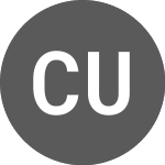
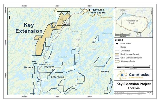
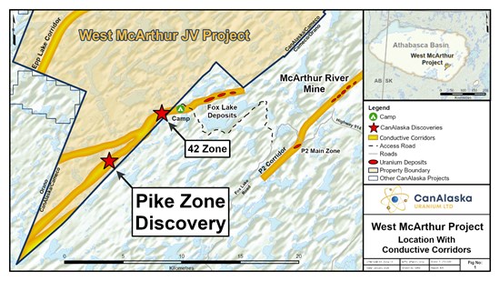
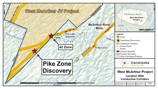

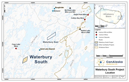
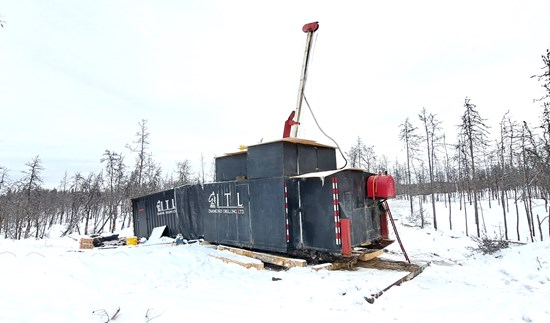
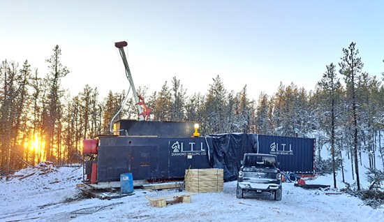
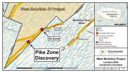
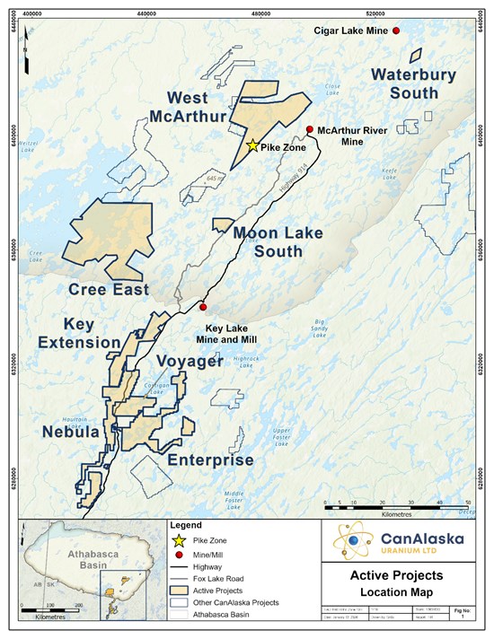
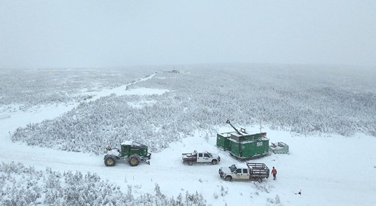
 nowwhat2
5年前
nowwhat2
5年前

 メールアドレスで登録